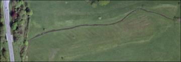
Case study:West Lexham Rehabilitation Project
Project overview
| Status | Complete |
|---|---|
| Project web site | |
| Themes | Habitat and biodiversity |
| Country | England |
| Main contact forename | Nigel T.H. |
| Main contact surname | Holmes |
| Main contact user ID | |
| Contact organisation | |
| Contact organisation web site | |
| Partner organisations | River Restoration Centre, Environment Agency, Norfolk County Council, Natural England |
| This is a parent project encompassing the following projects |
Project summary
A half day work to remove the impounding influence of a weir, and in the channel upstream four pools and runs were dug. A second weir, between two bridges c35m downstream of the one shown in the images, was also removed. This structure had minimal impact on habitat, but was an impediment to easy migration of fish etc. wishing pass upstream.
The structure within the meadow that was impounding the Nar upstream had some archaeological interest. For this reason there was a ‘watching brief’ from Norfolk County Council to ensure there was no damage done to any known existing interest features, and to record anything else of interest should this be revealed during the removal of the impounding structure. To minimise damage to the historical elements of the bridge, the concrete ‘boards’ were removed with great care, leaving the central pillar and upper lintel in place, yet drawing the bed down to the required level.
The effect of centuries of impoundment has been to create a sluggish/non-existent flow in the river upstream with the resultant deposition of thick layers of mud. Pools were created by widening the channel locally. To help keep the pools clear in the future, the channel was narrowed upstream. Due to the extreme depth of soft mud, narrowing was achieved by pushing in one side of the existing river edge with the back of the bucket, and the void created behind this was filled with the arisings from creating the pools. Four pools and upstream ‘runs’ were created, with the run formed upstream of the second pool from the top having a small amount of gravel spread on the bed – this was won from the bed of the river in the pool downstream.
Monitoring surveys and results
Lessons learnt
Image gallery
|
Catchment and subcatchmentSelect a catchment/subcatchment
Catchment
Subcatchment
Other case studies in this subcatchment: Castle Acre Rehabilitation Project, Nar SSSI project, Narborough Rehabilitation Project, River Nar Castle Acre Common WEG project, River Nar Restoration Project, River Nar, Mileham River Restoration Project
Site
Project background
Cost for project phases
Reasons for river restoration
Measures
MonitoringHydromorphological quality elements
Biological quality elements
Physico-chemical quality elements
Any other monitoring, e.g. social, economic
Monitoring documents
Additional documents and videos
Additional links and references
Supplementary InformationEdit Supplementary Information
| ||||||||||||||||||||||||||||||||||||||||||||||||||||||||||||||||||||||||||||||||||||||||||||||||||||||||||||||||||||||||||||||||||||||||||||||||||||||||||||||||||||||||||||||||||||||||||||||||||||||||

