Case study:River Nene Nature Improvement Area: Difference between revisions
No edit summary |
No edit summary |
||
| (24 intermediate revisions by 5 users not shown) | |||
| Line 1: | Line 1: | ||
{{Case study status | {{Case study status | ||
|Approval status= | |Approval status=Approved | ||
}} | }} | ||
{{Location | {{Location | ||
| Line 8: | Line 8: | ||
{{Project overview | {{Project overview | ||
|Status=In progress | |Status=In progress | ||
|Project web site url=www.naturalengland.org.uk/ourwork/conservation/biodiversity/funding/nia/projects/nenevalley.aspx | |Project web site url=webarchive.nationalarchives.gov.uk/20140605090108/http://www.naturalengland.org.uk/ourwork/conservation/biodiversity/funding/nia/projects/nenevalley.aspx | ||
|Themes=Economic aspects, Fisheries, Flood risk management, Habitat and biodiversity, Hydromorphology, Social benefits, Urban | |Themes=Economic aspects, Fisheries, Flood risk management, Habitat and biodiversity, Hydromorphology, Social benefits, Urban | ||
|Country=England | |Country=England | ||
| Line 15: | Line 15: | ||
|Contact organisation=River Restoration Centre | |Contact organisation=River Restoration Centre | ||
|Contact organisation url=www.therrc.co.uk | |Contact organisation url=www.therrc.co.uk | ||
|Partner organisations=Natural England, Wildlife Trust for Bedfordshire, Cambridgeshire and Northamptonshire | |Partner organisations=Natural England, Wildlife Trust for Bedfordshire, Cambridgeshire and Northamptonshire | ||
|Multi-site=No | |Multi-site=No | ||
|Project picture=Ise rushton loop.jpg | |Project picture=Ise rushton loop.jpg | ||
|Picture description=Backwater created on the River Ise (Rushton Loop) | |||
|Project summary=What is the Nene Valley NIA? | |||
Nature Improvement Areas (NIAs) were introduced by the government’s Natural Environment White Paper (June 2011) to “enhance and reconnect nature on a significant scale”. The Nene Valley NIA includes the River Nene and its main tributaries, plus a 3km radius on either side, from Daventry to Peterborough (41,350 hectares in total), and contains a fragmented network of statutory and non- statutory sites, such as SSSIs and SAPs. At 161km, it is the tenth longest river in the UK, and, being navigable from the Wash to Northampton (142km), is highly managed with locks and other infrastructure. | |||
It is located in the UK’s second largest growth area and is therefore exposed to significant development pressure. These include built development, increasing inappropriate public access, and competition for water resources. Land management practices threaten ecosystem services and the connectivity of habitats. | |||
Aims and objectives: | |||
The NIA will reverse the decline in biodiversity and restore the ecological network in the Nene Valley. It will help meet the challenges of a growing population, changing climate, and need to produce food while realising complimentary benefits that create a naturally functioning interlinked landscape. | |||
The NIA has 5 objectives, including: enhancing public access and awareness of the NIA; supporting development which will benefit the natural environment; engaging with farmers and improving ecosystems services. The Nene NIA is currently funded from 2013-2015 by Natural England. | |||
Objective 3 of the NIA is to “improve the ecological status of the river and enhance ecosystem service provision”. Much of the Nene is in Water Framework Directive poor ecological status due to diffuse pollution, water abstraction, and heavily modified river morphology due to channel alteration for navigation and flood risk management. These issues account for approximately 75% of the reasons for waterbodies in the Nene catchment failing to meet good status or potential. | |||
The Nene Valley NIA Partnership was formed by its stakeholders to enable a strategic and joined up approach to tackling these issues. The stakeholders form a coalition of experts including new partners and others well established in the valley. These include; River Nene Regional Park, the Environment Agency, the Bedfordshire, Cambridgeshire and Northamptonshire Wildlife Trust and the River Restoration Centre. | |||
|Monitoring surveys and results=Under objective 3 of the NIA walkover surveys to assess the habitat of the main Nene have been completed. Walkovers are also used to identify opportunities for habitat restoration. The river’s major tributaries are now being assessed. | |||
So far three projects have been delivered: | |||
*Duston, Northampton: marginal habitat has been improved upstream of St James End Weir. | |||
*Rushton, near Kettering: a 45m-long backwater has been created by excavating part of an old meander loop. | |||
*Orton Lock, Peterborough: an area of bank erosion downstream of the lock has been stabilised by “cutting & hinging” live willow into the scour holes and then adding further brushwood. | |||
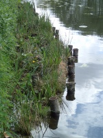
Restoration options on the main river are limited due to navigation and flood risk management. Proposed projects include the construction of fish easements on barriers, the excavation/re-connection of backwaters for fish spawning and refuges and improving urban marginal river habitats. | |||
}} | }} | ||
{{Image gallery}} | {{Image gallery}} | ||
{{Case study image | |||
|File name=P5020262.JPG | |||
|Caption=An example of improved urban marginal river habitat on the Nene | |||
}} | |||
{{Case study image | |||
|File name=Orton lock.png | |||
|Caption=Scour holes at Orton lock packed with woody material | |||
}} | |||
{{Case study image | |||
|File name=Duston.png | |||
|Caption=Marginal habitat improvement upstream of St James End Weir at Duston, Northamptonshire | |||
}} | |||
{{Case study image | |||
|File name=08a.JPG | |||
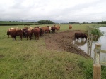
|Caption=Cattle poaching causing bank erosion on the Nene | |||
}} | |||
{{Case study image | |||
|File name=PB070367.JPG | |||
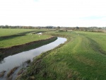
|Caption=Heavily modified channel of the Nene: dredging and construction of flood bunds to contain high flows disconnecting the river from its floodplain | |||
}} | |||
{{Image gallery end}} | {{Image gallery end}} | ||
{{Toggle button}} | {{Toggle button}} | ||
{{Toggle content start}} | {{Toggle content start}} | ||
{{Case study subcatchment}} | {{Case study subcatchment | ||
{{Site}} | |Subcatchment=Nene | ||
}} | |||
{{Site | |||
|WFD water body code=GB105032045300 | |||
|WFD water body name=Nene | |||
|Heavily modified water body=No | |||
|Protected species present=No | |||
|Invasive species present=No | |||
}} | |||
{{Project background}} | {{Project background}} | ||
{{Motivations}} | {{Motivations | ||
{{Measures}} | |Specific mitigation=Barriers to fish migration, Flood risk management, Impoundments (not hydropower), Navigation, Urbanisation, | ||
|Hydromorphological quality elements=Channel pattern/planform, Continuity for organisms, Continuity of sediment transport, Quantity & dynamics of flow, | |||
|Biological quality elements=Fish, Invertebrates, | |||
|Physico-chemical quality elements=Nutrient concentrations, Specific synthetic pollutants, | |||
}} | |||
{{Measures | |||
|Bank and bed modifications measure=Bank improvement, Bank stabilisation, Creation of fish refuge areas, Fenced off riverbank, Habitat diversification, | |||
|Floodplain / River corridor=Installing riverside fencing, Reduce diffuse pollution, Creation of backwaters, Installing riverside fencing, Riparian planting, | |||
|Planform / Channel pattern=Creation of backwater, | |||
}} | |||
{{Hydromorphological quality elements header}} | {{Hydromorphological quality elements header}} | ||
{{End table}} | {{End table}} | ||
| Line 39: | Line 98: | ||
{{Monitoring documents end}} | {{Monitoring documents end}} | ||
{{Additional Documents}} | {{Additional Documents}} | ||
{{Case study documents | |||
|File name=SPARCUK(web).pdf | |||
|Description=SPARC project magazine | |||
}} | |||
{{Case study documents | |||
|File name=Integration of River Corridors in Landscape Design.pdf | |||
|Description=Integration of river corridors in landscape design | |||
}} | |||
{{Additional Documents end}} | {{Additional Documents end}} | ||
{{Additional links and references header}} | {{Additional links and references header}} | ||
{{Additional links and references | |||
|Link=www.nenevalleynia.org/ | |||
|Description=Nene Valley NIA website | |||
}} | |||
{{Additional links and references | |||
|Link=www.wildlifebcn.org/thenenevalley/nia | |||
|Description=Wildlife Trusts BCN website - Nene Valley NIA | |||
}} | |||
{{Additional links and references | |||
|Link=www.riverneneregionalpark.org/default.asp?PageID=436 | |||
|Description=River Nene Regional Park website | |||
}} | |||
{{Additional links and references | |||
|Link=www.riverneneregionalpark.org/images/PDF_Files/River_Nene_Regional_Park/Projects/NICP/Nene%20Catchment%20Reportw.pdf | |||
|Description=Draft River Nene Catchment Management Plan | |||
}} | |||
{{Additional links and references footer}} | {{Additional links and references footer}} | ||
{{Supplementary Information}} | {{Supplementary Information}} | ||
{{Toggle content end}} | {{Toggle content end}} | ||
Latest revision as of 10:59, 5 June 2017
Project overview
| Status | In progress |
|---|---|
| Project web site | http://webarchive.nationalarchives.gov.uk/20140605090108/http://www.naturalengland.org.uk/ourwork/conservation/biodiversity/funding/nia/projects/nenevalley.aspx |
| Themes | Economic aspects, Fisheries, Flood risk management, Habitat and biodiversity, Hydromorphology, Social benefits, Urban |
| Country | England |
| Main contact forename | Simon |
| Main contact surname | Whitton |
| Main contact user ID | |
| Contact organisation | River Restoration Centre |
| Contact organisation web site | http://www.therrc.co.uk |
| Partner organisations | Natural England, Wildlife Trust for Bedfordshire, Cambridgeshire and Northamptonshire |
| Parent multi-site project | |
| This is a parent project encompassing the following projects |
No |
Project summary
What is the Nene Valley NIA?
Nature Improvement Areas (NIAs) were introduced by the government’s Natural Environment White Paper (June 2011) to “enhance and reconnect nature on a significant scale”. The Nene Valley NIA includes the River Nene and its main tributaries, plus a 3km radius on either side, from Daventry to Peterborough (41,350 hectares in total), and contains a fragmented network of statutory and non- statutory sites, such as SSSIs and SAPs. At 161km, it is the tenth longest river in the UK, and, being navigable from the Wash to Northampton (142km), is highly managed with locks and other infrastructure.
It is located in the UK’s second largest growth area and is therefore exposed to significant development pressure. These include built development, increasing inappropriate public access, and competition for water resources. Land management practices threaten ecosystem services and the connectivity of habitats.
Aims and objectives: The NIA will reverse the decline in biodiversity and restore the ecological network in the Nene Valley. It will help meet the challenges of a growing population, changing climate, and need to produce food while realising complimentary benefits that create a naturally functioning interlinked landscape. The NIA has 5 objectives, including: enhancing public access and awareness of the NIA; supporting development which will benefit the natural environment; engaging with farmers and improving ecosystems services. The Nene NIA is currently funded from 2013-2015 by Natural England.
Objective 3 of the NIA is to “improve the ecological status of the river and enhance ecosystem service provision”. Much of the Nene is in Water Framework Directive poor ecological status due to diffuse pollution, water abstraction, and heavily modified river morphology due to channel alteration for navigation and flood risk management. These issues account for approximately 75% of the reasons for waterbodies in the Nene catchment failing to meet good status or potential.
The Nene Valley NIA Partnership was formed by its stakeholders to enable a strategic and joined up approach to tackling these issues. The stakeholders form a coalition of experts including new partners and others well established in the valley. These include; River Nene Regional Park, the Environment Agency, the Bedfordshire, Cambridgeshire and Northamptonshire Wildlife Trust and the River Restoration Centre.
Monitoring surveys and results
Under objective 3 of the NIA walkover surveys to assess the habitat of the main Nene have been completed. Walkovers are also used to identify opportunities for habitat restoration. The river’s major tributaries are now being assessed.
So far three projects have been delivered:
- Duston, Northampton: marginal habitat has been improved upstream of St James End Weir.
- Rushton, near Kettering: a 45m-long backwater has been created by excavating part of an old meander loop.
- Orton Lock, Peterborough: an area of bank erosion downstream of the lock has been stabilised by “cutting & hinging” live willow into the scour holes and then adding further brushwood.
Restoration options on the main river are limited due to navigation and flood risk management. Proposed projects include the construction of fish easements on barriers, the excavation/re-connection of backwaters for fish spawning and refuges and improving urban marginal river habitats.
Lessons learnt
Image gallery
|
Catchment and subcatchmentSelect a catchment/subcatchment
Catchment
Subcatchment
Other case studies in this subcatchment: Resilient River
Site
Project background
Cost for project phases
Reasons for river restoration
Measures
MonitoringHydromorphological quality elements
Biological quality elements
Physico-chemical quality elements
Any other monitoring, e.g. social, economic
Monitoring documents
Additional documents and videos
Additional links and references
Supplementary InformationEdit Supplementary Information
| ||||||||||||||||||||||||||||||||||||||||||||||||||||||||||||||||||||||||||||||||||||||||||||||||||||||||||||||||||||||||||||||||||||||||||||||||||||||||||||||||||||||||||||||||||||||||||||||||||||||


