Case study:The Mid River Crane - Aquatic Refuge Identification Plan
Project overview
| Status | Planned |
|---|---|
| Project web site | http://cranevalley.org.uk/ |
| Themes | Fisheries, Habitat and biodiversity, Urban |
| Country | England |
| Main contact forename | Gareth |
| Main contact surname | Ryman |
| Main contact user ID | |
| Contact organisation | London Wildlife Trust |
| Contact organisation web site | |
| Partner organisations | |
| This is a parent project encompassing the following projects |
Project summary
Aquatic Refuges
Aquatic refuges are physical places within a river corridor that allow populations of aquatic organisms to persist during times of disturbance. Disturbances experienced by the River Crane include sudden increases in flow and river levels, minor flooding, and pollution events. The organisms harboured in a refuge are able to re-colonise the main river when the disturbance has passed.
Importance of Aquatic Refuges for heavily modified water bodies
Anthropogenic alterations to the flow regime and floodplain connectivity of lowland rivers have been observed to have detrimental impacts on fish populations (Bolland, 2008). The River Crane is a heavily modified water body with poor connectivity to its floodplain. In unmodified lowland rivers, floods are characterized by lateral expansion onto floodplains resulting in high levels of habitat heterogeneity, essential for fish refuge, spawning, nursery and feeding (Bolland, 2008).
Cowx & Gerdeaux (2004) suggested the necessity of recreating functional habitats for spawning, feeding, nursery(growth) and resting (self protection) on heavily modified river channels. Recreating these types of habitats involves softening levees and reconnecting secondary channels (backwaters) and isolated oxbows (Lusk et al., 2001, 2003). Such restoration efforts may only be necessary in limited reaches of a river corridor to maintain the biodiversity of a fishery (Cowx & Welcomme, 1998).
Aim of this project
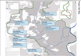
This report aims to assess feasibility of creating aquatic refuge areas along the mid-Crane (between Crane Park and Cranford Park) in order to create functional habitats for coarse fish spawning, feeding, nursery and resting. Some sites may also have the potential for habitat enhancements for water voles and aquatic invertebrates. Sites are ordered via location, downstream to upstream.
References:
Bolland, J.D. (2008). Factors affecting the dispersal of coarse fish. Thesis submitted for the degree of doctor of philosophy. The University of Hull. Cowx, I.G. & Gerdeaux, D. (2004). The effects of fisheries management practices on freshwater ecosystems, Fisheries Management and Ecology 11, 145-152. Cowx, I.G. & Welcome, R.L. (1998). Rehabilitation of Rivers for Fish. Oxford: Fishing News Books, Blackwell Science, 260 pp. Lusk, S., Halacka, K. & Luskova, V. (2003) Rehabilitation the floodplain of the lower River Dyje for fish. River Reseach and Applications. 19, 281-288 Lusk, S., Halacka, K. & Luskova, V. & Horak, V. (2001). Annual dynamics of the fish stock in a backwater of the River Dyje. Regulated Rivers: Research and Management 17, 571-581.
Monitoring surveys and results
Lessons learnt
Image gallery
|
Catchment and subcatchmentSelect a catchment/subcatchment
Catchment
Subcatchment
Other case studies in this subcatchment: Big Yellow, Crane Park, Cranford Park Phase 2, Hospital Bridge Road, Mill Road Weir, Re-connecting Meanders at Cranebank on the River Crane
Site
Project background
Cost for project phases
Reasons for river restoration
Measures
MonitoringHydromorphological quality elements
Biological quality elements
Physico-chemical quality elements
Any other monitoring, e.g. social, economic
Monitoring documents
Additional documents and videos
Additional links and references
Supplementary InformationEdit Supplementary Information
| ||||||||||||||||||||||||||||||||||||||||||||||||||||||||||||||||||||||||||||||||||||||||||||||||||||||||||||||||||||||||||||||||||||||||||||||||||||||||||||||||||||||||||||||||||||||||||||||||||||||||||||

