Case study:River Stour Habitat Enhancements at Great and Little Bradley
Project overview
| Status | Complete |
|---|---|
| Project web site | |
| Themes | Fisheries, Habitat and biodiversity |
| Country | England |
| Main contact forename | Alex |
| Main contact surname | Moore da Luz |
| Main contact user ID | User:Dedhamvale |
| Contact organisation | Dedham Vale AONB |
| Contact organisation web site | http://www.dedhamvalestourvalley.org |
| Partner organisations | Environment Agency |
| Parent multi-site project | |
| This is a parent project encompassing the following projects |
No |
Project summary
The ecological value of this stretch is limited by three key factors: poor water quality due to agricultural run-off; barriers to longitudinal connectivity in the form of water-level control structures associated with the Ely-Ouse Transfer Scheme; and the periodic flushing of vast quantities of water through the reach due to the Ely-Ouse Transfer scheme. As a result large sections of the river here are dominated by epilithic and floating algae, which are prevalent in areas of slow-moving water. Several frogs were also seen in such areas, alongside invasive, non-native American signal crayfish.
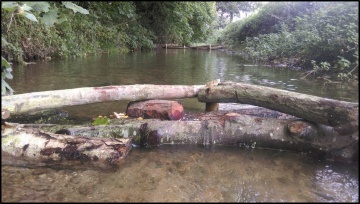
The scheme focused upon maximising the habitat diversity of the river with the view that water quality and quantity issues can addressed at as later date, either as part of or separate to this project. In particular the scheme concentrated upon creating those habitats that are currently lacking within the river. In total 94 woody debris features (including flow deflectors, log jams and brushwood shelves) have been installed by EA and AONB Project staff and volunteers. Using large woody material had the dual benefit of instantaneously increasing oxygenation and flow diversity whilst simultaneously adding structural complexity and cover. Flow deflectors (large pieces of natural wood) were used to accentuate sinuosity in areas that already exhibited meander initiation and for encouraging bed scour in reaches that were comparatively straight. Flow deflectors were orientated downstream at an angle from the bank between 30° and 45°. The length of the deflectors varied but ideally each structure typically occupied between 50-75% of the channel width. Where possible, deflectors were installed on alternating sides of the river to increase channel sinuosity. The distance between deflectors averaged around 25m longitudinal river length, although this varied according to local conditions. Flow deflectors were placed upon the bed of the river and built to varying heights so that different deflectors are effective under different flow conditions. The reasons for using wooden flow deflectors are manifold. Most broadly, reintroducing woody-material to a river creates variations in flow velocity and depth. Diverse flows create diverse habitats, such as slow-flow pool areas where fish can rest when migrating upstream. Variations in flow also create variations in fluvial geomorphological processes, with flow deflectors often being the instigator in the development of erosion. The physical structure of flow deflector installations can also have benefits, providing an important refuge for fish and other in-stream organisms where they can avoid predation. Increased channel roughness and the resultant fluid turbulence through reaches containing flow deflectors often increases the concentration of dissolved oxygen in these sections, further improving fish habitat. More specifically, flow deflectors can be used to narrow the river channel and encourage the development of berms in river reaches that have been over-widened. Artificial log-jams perform a number of functions. Firstly, the localised backing-up effect caused by the jam is likely to force fine sediment to fall out of suspension and accumulate upstream of the structure, thereby reducing its entrainment downstream. Secondly, the water falling over the log-jam may generate a small scour pool from which gravel is excavated and transported downstream to create further features. This creates a habitat in itself, as well as facilitating bed scour and landform creation. Thirdly, the log-jam oxygenates water, provides a refuge for organisms and creates a permeable barrier between two distinct ecotones (the slow-flowing, backed-up upstream habitat and the fast-flowing, slightly derogated downstream habitat). All log-jams were constructed of wood that spanned the entirety of the channel. The maximum height of the log-jams was no more than 20cm above the existing bed level. Where possible the jams were constructed of a single piece of large wood, cut to the dimensions of the channel. All of the log-jams were secured in place using vertical stakes driven into the bed of the river using a post driver, mallet or digger-bucket tool. 4ft and 6ft oak were used construction, whilst some stakes were made from local tree branches. Vertical and horizontal pieces of wood were secured together using 100mm and 150mm timber screws. The sides of each log-jam were dug into the banks of the river where possible. All of the aforementioned measures were taken to ensure the maximum environmental benefit whilst still securing the structures.
Monitoring surveys and results
Lessons learnt
Image gallery
|
Catchment and subcatchmentSelect a catchment/subcatchment
Catchment
Subcatchment
Site
Project background
Cost for project phases
Reasons for river restoration
Measures
MonitoringHydromorphological quality elements
Biological quality elements
Physico-chemical quality elements
Any other monitoring, e.g. social, economic
Monitoring documents
Additional documents and videos
Additional links and references
Supplementary InformationEdit Supplementary Information
| ||||||||||||||||||||||||||||||||||||||||||||||||||||||||||||||||||||||||||||||||||||||||||||||||||||||||||||||||||||||||||||||||||||||||||||||||||||||||||||||||||||||||||||||||||||||||||||||

