Case study:River Slea Rehabilitation
Project overview
| Status | Complete |
|---|---|
| Project web site | |
| Themes | Habitat and biodiversity, Social benefits, Urban |
| Country | England |
| Main contact forename | Marie |
| Main contact surname | Taylor |
| Main contact user ID | |
| Contact organisation | Lincolnshire Rivers Trust |
| Contact organisation web site | http://www.lincsrivers.org.uk/ |
| Partner organisations | Wild Trout Trust |
| Parent multi-site project | |
| This is a parent project encompassing the following projects |
No |
Project summary
The River Slea is an 18 mile long tributary of the River Witham, Lincolnshire. The River Slea is groundwater fed from Lincolnshire limestone aquifer and the flow depends on the on groundwater levels. Historically the River Slea flowed all year round. In the early 60s the flow of the river began to slow and ceased in 1962. This was due to a number of reasons such as over abstraction, increase in population and changes in weather cycles. After a public campaign in 1992, a pump was installed by the Environment Agency which delivers groundwater to the river at times of no flow. The Lincolnshire Rivers Trust (LRT) commissioned Clear Environmental to deliver the Sleaford Urban Opportunities Study, which was funded by Natural England. This study highlighted how the river would benefit from various rehabilitation techniques to enable wildlife to be more resilient during low flow periods and also contribute towards WFD objectives. With the help of the Wild Trout Trust, three sections of river were identified where restoration could be completed, this covered approximately 1.2km of river. Unfortunately, due to site constraints, work could only be completed on two sections (sections one and two). There were three phases to the works completed, these are detailed below;
Phase 1: Using an excavator, a low flow channel was created in section one and pools were created in section two. River bed material removed was used to create berms and meanders within the existing channel.
Phase 2: Brushwood bundles were installed, to construct berms which created pinch points, narrowing the channel to speed up the flow and maintain the pools created. This part of the project was made possible with the help of volunteers.
Phase 3: Planting of vegetation using coir matting and plug plants, to increase the rate of colonisation of berms and make them appear more natural.
Monitoring surveys and results
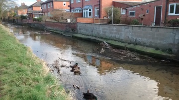
In September 2015, section one of the river was completely dry, but following the creation of the low flow channel, in September 2016 there was still 1ft of water retained within that section.
Before the works were completed, a water vole survey carried out in 2015 only found old unused burrows, with no signs of water voles. In 2016 another water vole survey was carried out, detecting 12 feeding stations and four latrines.
In 2015 section two was completely uniform with no pools or any habitat features. Following the work, 22 berms were constructed providing cover for fish and providing deeper areas that would help maintain the depth during low flow periods. Planting was successful, and in time, the vegetation will grow and create a natural meandering flow.
Lessons learnt
Work could not be carried out in section 3 due to the firmness of the riverbed. It is reccomended in the future that the firmness of the riverbed should be tested to ensure habitat improvement works can be carried out.
Install coir matting vegetation at the same time as installing brushwood, we had to rely on individual plug plants when planting. Although plugs are cheaper than matting.
Image gallery
|
Catchment and subcatchment
Site
Project background
Cost for project phases
Reasons for river restoration
Measures
MonitoringHydromorphological quality elements
Biological quality elements
Physico-chemical quality elements
Any other monitoring, e.g. social, economic
Monitoring documents
Additional documents and videos
Additional links and references
Supplementary InformationEdit Supplementary Information
| ||||||||||||||||||||||||||||||||||||||||||||||||||||||||||||||||||||||||||||||||||||||||||||||||||||||||||||||||||||||||||||||||||||||||||||||||||||||||||||||||||||||||||||||||||

