Case study:River Idle Hallcroft (Tiln) Weir Fish Pass
Project overview
| Status | Complete |
|---|---|
| Project web site | |
| Themes | Fisheries |
| Country | England |
| Main contact forename | Joel |
| Main contact surname | Rawlinson |
| Main contact user ID | |
| Contact organisation | Environment Agency |
| Contact organisation web site | |
| Partner organisations | |
| Parent multi-site project | |
| This is a parent project encompassing the following projects |
No |
Project summary
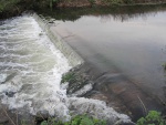
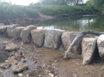
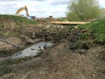
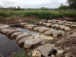
To meet targets set by the Water Framework Directive (WFD), the Environment Agency completed a programme of habitat improvement works on the River Idle which is a major tributary to the River Trent. This project concerns Hallcroft Weir (AKA as Tiln Weir) in Retford, Nottinghamshire (SK69275 83396).
Hallcroft Weir, located on the River Idle in Nottinghamshire is approximately 30-35km from the confluence at which the Idle meets the tidal Trent. Not including the sluice / pumping station control structures at the confluence, Hallcroft weir is the first physical barrier encountered by upstream migrating fish. Although originally passable to some species of fish, a combination of head loss and flow limited certain species ability to pass the weir.
Hallcroft Weir is an Environment Agency owned asset. The weir is a broad crested type weir spanning the full channel width and running perpendicular to the flow. Downstream of the weir is a non-official rock ramp extending from approximately 1m downstream of the weir toe for 15m.
The weir at Hallcroft prevented free movement of fish, particularly in an upstream direction. It was impassable to many species of fish under most flow conditions due to velocity and depth of flow.
The project aim was to increase the migratory ability of all fish species in the River Idle and in particular eels. This will lead to a more sustainable population within the catchment as the work will allow the migrating eels and other fish species to reach more upstream habitat.
The total project costs a 260,000GBP.
Monitoring surveys and results
Following implementation of the fish pass improvements, we will monitor the impact through on-going survey work, which can be compared to past survey results. We have long term monitoring sites up and downstream of Hallcroft weir that have been monitored since the 1990’s - upstream at Eaton and downstream at Chain Bridge. Samples are usually taken in early May, so there will be a sample just before the project takes place and then we will get post project result the following May. These standardised monitoring results can also be compared to catch returns from the local angling clubs.
Lessons learnt
Image gallery
|
Catchment and subcatchmentSelect a catchment/subcatchment
Catchment
Subcatchment
Site
Project background
Cost for project phases
Reasons for river restoration
Measures
MonitoringHydromorphological quality elements
Biological quality elements
Physico-chemical quality elements
Any other monitoring, e.g. social, economic
Monitoring documents
Additional documents and videos
Additional links and references
Supplementary InformationEdit Supplementary Information
| ||||||||||||||||||||||||||||||||||||||||||||||||||||||||||||||||||||||||||||||||||||||||||||||||||||||||||||||||||||||||||||||||||||||||||||||||||||||||||||||||||||||||||||||||||||||||||||||||||||||||


