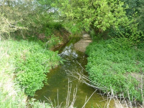
Case study:Plough Hill Farm Meander and Wet meadow restoration
Project overview
| Status | In progress |
|---|---|
| Project web site | |
| Themes | Habitat and biodiversity, Hydromorphology |
| Country | England |
| Main contact forename | Kieren |
| Main contact surname | Alexander |
| Main contact user ID | User:KierenAlexander |
| Contact organisation | Essex Wildlife Trust |
| Contact organisation web site | http://http://essexrivershub.org.uk/ |
| Partner organisations | |
| Parent multi-site project | |
| This is a parent project encompassing the following projects |
No |
Project summary
This project furthers the development of the River Pant and builds on the work undertaken at Millfield, Bocking and Ironbridge farm. The aim of all three projects is to target an improvement in the River Pant under the Water Framework Directive.
Currently the river is failing under the Water Framework directive. There are a number of overriding issues in this waterbody most notably a heavily modified water body that has become disconnected from the floodplain, phosphate and diffuse pollution input, point source and fish passage.
Whilst it is impossible that this project will single handedly turn around this assessment, it will along with the other projects begin to make a difference to this waterbody and start to improve it ecologically and with multi benefits such as flood alleviation seeing improvements.
This is a fairly simple intervention and is focused around enhancing existing geomorphological processes such as riffle creation, and sediment deposition. Both are of major benefits to invertebrates, spawning fish and fish fry, which are arguably the key components in any river's ecosystem.
We aim to improve the river by opening up an old meander bend. Historically the river would have flowed around this bend but at some point in the past this has been straightened. This has left a relict channel which is partially open at one end. This floods but only infrequently, we aim to connect at one end to allow increased wetting up. This will have a series of effects, it will promote aquatic and emergent vegetation in the derelict channel, it will provide a fish fry refuge at time of high flows and offer some flood alleviation by increasing connectivity with the floodplain and allow silt to settle out of the floodplain.
In addition to the above, three pieces of woody debris will be installed which will further kick start geomorphic processes, in this case riffles, bank and bottom erosion and deposition. The woody debris allow pollutants to be filtered out, berms to be created and river flow to be more dynamic. Beyond the works on the river there will also be some hedge planting to connect up the landscape and the river and allow birds and other animals to move freely around the project site and other
Work has now been consented and has received planning permission and once the bird breeding season is complete, work will commence. Physical earthworks will take around a week to complete.
Monitoring surveys and results
Fixed point photography will be used to assess vegetation changes and changes in river performance.
Lessons learnt
This is a small project, total cost is expected to be less than 5k. However, it still has to be treated as if it is a major project. This has led to a very bottom heavy project with a substantially more spent on the consenting process rather than the delivering the project. There is a strong argument to suggest that any river restoration project must be worth the consenting process and smaller projects may not offer value for money.
Image gallery
|
Catchment and subcatchmentSelect a catchment/subcatchment
Catchment
Subcatchment
Other case studies in this subcatchment: Ironbridge Farm, Millfield Plantation 2
Site
Project background
Cost for project phases
Reasons for river restoration
Measures
MonitoringHydromorphological quality elements
Biological quality elements
Physico-chemical quality elements
Any other monitoring, e.g. social, economic
Monitoring documents
Additional documents and videos
Additional links and references
Supplementary InformationEdit Supplementary Information
| ||||||||||||||||||||||||||||||||||||||||||||||||||||||||||||||||||||||||||||||||||||||||||||||||||||||||||||||||||||||||||||||||||||||||||||||||||||||||||||||||||||||||||||||||||||||||||||||||||||||||||

