Case study:Lullingstone Castle
Project overview
| Status | Complete |
|---|---|
| Project web site | |
| Themes | Fisheries, Habitat and biodiversity, Hydromorphology |
| Country | England |
| Main contact forename | Louise |
| Main contact surname | Smith |
| Main contact user ID | |
| Contact organisation | North West Kent Countryside Partnership |
| Contact organisation web site | |
| Partner organisations | |
| Parent multi-site project | |
| This is a parent project encompassing the following projects |
No |
Project summary
The River Darent is a tributary of the River Thames. This groundwater fed chalk river exhibits typical attributes including clear water, abundant macrophytes, low banks and reasonably stable flows.
The river has suffered from over abstraction as well as being heavily modified for historical agricultural irrigation and to provide power for milling. The rivers course through a number of large lakes fragment habitats and puts pressure on water quality and quantity in the river.
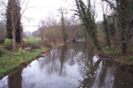
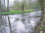
The North West Kent Countryside Partnership (NWKCP) and King Fisher Angling and Preservation Society (KAPS)carried out a project in 2010/2011 on the Darent running through the grounds of Lullingstone Castle. The Wild Trout Trust undertook an advisory visit in July 2009 to identify the project area which exhibited historical straightening, slow flows and high water temperatures due to its location just downstream of a 15ha on-line lake. Heavy siltation in the channel and dense wooded banks also contributed to an overall poor habitat for fish (particularly native Brown Trout).
Objectives included:
• Improve in stream habitat for juvenile and adult fish as well as provision of spawning habitats by the creation of areas of clean loose gravels and increased flow rates
• Increased flow levels to ensure a healthy flow to maintain habitats even during summer low flows
• Increase marginal habitats by clearing trees and scrub and planting new marginal aquatic plants to support invertebrate, wildfowl and water vole populations
• Narrowing and meandering of the channel using large woody debris and faggots
• Increase fishing opportunities by improving condition of the river
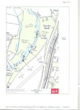
The Environment Agency initiated the project, with the North West Kent Countryside Partnership engaging with local fishing clubs who had initially developed and planned the project to provide advice and support work delivery. This partnership ensured the ability to deliver a wide range of objectives. Project delivery was between January and April 2011 (to correspond with the closed fishing season) by KAPS and NWKCP staff and volunteers. The Environment Agency funded the £3,640 cost including materials and NWKCP officer time. The reach was divided into sections A-F a brief review of work completed is:
A- Installation of deflector
B- Channel narrowing, faggoting to encourage new bank development and increase marginal habitat
C- Faggot barrier to block inlet, installation of coir rolls between faggot bundles to create vegetation
D- Block off artificial channels by installing faggots, planting area using coir pallets
E- Installation of large woody debris and coir rolls to narrow channel
F- Group deflectors at varying lengths, pack faggot bundles between deflectors to create marginal habitats
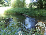
These works have been a success, making a noticeable difference to fishing quality (reports of increased catch rates). A reach has now been created which provides a variety of habitats beneficial to fish, and has encouraged possible spawning activity in the area. The KAPS and NWKCP are keen to continue works and have begun identification of possible sites for the future. Since 2011 the North West Kent Countryside Partnership have revisited the project to deliver additional habitat improvement works. The additional work undertaken included the installation of large woody debris to create a set of 'v' deflectors which have established another pool and riffle sequence and helped to increase the flow within this location. The work provides additional spawning opportunity for fish as well as offering greater diversity in the types of habitat available. The Partnership has also modified an overly wide canalised section (area F) to increase the depth and the flow rate through this section. The narrowing has also improved the scouring effect of the existing deflectors, helping to remove the heavy silt on the river bed and expose the gravels.
The RRC would like to thank Louise Smith (North West Kent Countryside Partnership) for providing all project information, site map and pictures.
Monitoring surveys and results
Lessons learnt
Image gallery
|
Catchment and subcatchmentSelect a catchment/subcatchment
Catchment
Subcatchment
Other case studies in this subcatchment: Darent Valley Path, Lullingstone Castle phase 2, River Darent at Hawley Manor
Site
Project background
Cost for project phases
Reasons for river restoration
Measures
MonitoringHydromorphological quality elements
Biological quality elements
Physico-chemical quality elements
Any other monitoring, e.g. social, economic
Monitoring documents
Additional documents and videos
Additional links and references
Supplementary InformationEdit Supplementary Information
| ||||||||||||||||||||||||||||||||||||||||||||||||||||||||||||||||||||||||||||||||||||||||||||||||||||||||||||||||||||||||||||||||||||||||||||||||||||||||||||||||||||||||||||||||||||||||||||||||


