Case study:Llobregat river restoration

From RESTORE
Jump to navigation Jump to search
0.00
(0 votes)


To discuss or comment on this case study, please use the discussion page.


Location: 41° 25' 56.52" N, 1° 59' 52.06" E
Loading map...
Left click to look around in the map, and use the wheel of your mouse to zoom in and out.


Project overview

Edit project overview
Status Complete
Project web site
Themes Environmental flows and water resources, Habitat and biodiversity, Hydromorphology, Social benefits
Country Spain
Main contact forename Joan
Main contact surname Feliú
Main contact user ID
Contact organisation Acciónatura
Contact organisation web site
Partner organisations
Parent multi-site project
This is a parent project
encompassing the following
projects
No
Project picture

Project summary

Edit project overview to modify the project summary.


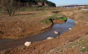
The river Llobregat lower course is the result of centuries of human activity. Historically it has tried to avoid overflows and maintain a constant channel in order to gain land for agriculture and to capture water for irrigation and industry. In recent years, construction of major infrastructures such as highway, the TGV and other service roads have come to narrow the river steadily reducing temporary floodplain. The important aspects are summarized in the following features: creating favorable conditions (morphological and hydraulic); stabilize the channel and enable the growth of vegetation compatible with the frequency of floods and flooding near the river; create riverside communities continue to function as a corridor; promote native species and eliminate the alien; recover the riparian habitat and all; lost and refuge areas for wildlife habitat; encourage and facilitate the enjoyment of the river by the population, with emphasis on landscape and ecological aspects and fen-it compatible with conservation.

Monitoring surveys and results

This case study hasn’t got any Monitoring survey and results, you can add some by editing the project overview.

Lessons learnt

This case study hasn’t got any lessons learnt, you can add some by editing the project overview.


Image gallery


Map of the restoration area
Reeds on the bank of the Llobregat River
Disposal of dead wooden logs and bird sanctuaries
Placement of stone blocks to improve channel structure. Reprofiling the banks
Reeds removal (before works)
Reeds removal
Wastes and debris in the channel before the cleaning tasks
Sheepherding on the banks of the Llobregat River
Volunteers planting vegetation on the banks
ShowHideAdditionalImage.png


Catchment and subcatchment

Catchment

River basin district Pirineo Oriental
River basin Llobregat

Subcatchment

River name Llobregat
Area category
Area (km2)
Maximum altitude category Less than 100 m
Maximum altitude (m) 25 m0.025 km <br />2,500 cm <br />
Dominant geology
Ecoregion Ibero-Macaronesian
Dominant land cover Urban
Waterbody ID


Other case studies in this subcatchment: Increased biodiversity, river Llobregat, Sallent.


Site

Name Pallejà
WFD water body codes
WFD (national) typology
WFD water body name
Pre-project morphology Sinuous, Braided
Reference morphology Sinuous, Braided
Desired post project morphology
Heavily modified water body
National/international site designation
Local/regional site designations
Protected species present
Invasive species present
Species of interest
Dominant hydrology
Dominant substrate
River corridor land use Urban
Average bankfull channel width category
Average bankfull channel width (m)
Average bankfull channel depth category
Average bankfull channel depth (m)
Mean discharge category
Mean annual discharge (m3/s) 20.7720.77 m³/s <br />20,770 l/s <br />
Average channel gradient category
Average channel gradient
Average unit stream power (W/m2)


Project background

Reach length directly affected (m) 170 m0.17 km <br />17,000 cm <br />
Project started 2009/01/01
Works started
Works completed 2010/01/01
Project completed
Total cost category
Total cost (k€)
Benefit to cost ratio
Funding sources ACA 70%, Accionatura 30%

Cost for project phases

Phase cost category cost exact (k€) Lead organisation Contact forename Contact surname
Investigation and design
Stakeholder engagement and communication
Works and works supervision
Post-project management and maintenance
Monitoring


Reasons for river restoration

Mitigation of a pressure
Hydromorphology Structure & condition of riparian zones, Channel pattern/planform, Width & depth variation
Biology
Physico-chemical
Other reasons for the project


Measures

Structural measures
Bank/bed modifications Revetmens with local species, Bank stabilisation
Floodplain / River corridor Riparian planting, Control of invasive species, Silvicultural treatments
Planform / Channel pattern Remove obstacles in the riverbed
Other
Non-structural measures
Management interventions
Social measures (incl. engagement)
Other


Monitoring

Hydromorphological quality elements

Element When monitored Type of monitoring Control site used Result
Before measures After measures Qualitative Quantitative

Biological quality elements

Element When monitored Type of monitoring Control site used Result
Before measures After measures Qualitative Quantitative

Physico-chemical quality elements

Element When monitored Type of monitoring Control site used Result
Before measures After measures Qualitative Quantitative

Any other monitoring, e.g. social, economic

Element When monitored Type of monitoring Control site used Result
Before measures After measures Qualitative Quantitative


Monitoring documents


Additional documents and videos


Additional links and references

Link Description

Supplementary Information

Edit Supplementary Information