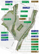
Case study:Dagenham Washlands Phase 2
Project overview
| Status | Complete |
|---|---|
| Project web site | |
| Themes | Environmental flows and water resources, Flood risk management, Habitat and biodiversity, Social benefits |
| Country | England |
| Main contact forename | Richard |
| Main contact surname | Hellier |
| Main contact user ID | |
| Contact organisation | Environment Agency |
| Contact organisation web site | http://www.gov.uk/government/organisations/environment-agency |
| Partner organisations | |
| Parent multi-site project | |
| This is a parent project encompassing the following projects |
No |
Project summary
Realignment of the Wantz through the floodplain in the open space away from the existing flood embankment and creation of more natural banks and profile along the River Beam where space allows. Introduction of meanders and backwaters will increase habitat and add interest to the park for the local community. Some wetlands have recently been created in the area as part of the Washland FAS project.
More detail on size: 58ha & 12ha of new BAP, 150m re-meandering (Wantz), 600m reprofiling and 300m in channel features (Beam). The Wantz Stream has been straightened and runs towards the edge of the space rather than being the visual focal point. Realignment would provide opportunities for wetland creation. The wetlands created as part of the washlands FAS scheme will help to inform the creation of any new habitats.
This project complements a £4.5 million capital scheme to make space for water and reduce the risk of flooding to 570 homes, 90 businesses (including the Ford Dagenham plant) major infrastructure (including Barking power station) and strategic development sites. The project was developed in partnership with Barking & Dagenham Council and the Land Restoration Trust (LRT), and provides BAP habitat within 53 hectares of regenerated open space. The local community were consulted on the design and investment came from the European Regional Development Fund, Thames Gateway Parkland Fund and the Landfill Tax Credit Scheme (LFTCS). The opportunity to make space accessible to existing and future communities was identified.
- Total costs - £3,767,000
- BAP habitat created (OM4) - 12.6 ha as part of 53 ha of fully functioning and accessible parkland
- Estimated economic benefits of the BAP habitat - £536,000
- Funding and Contributions:
- Environment Agency (MEICA (Mechanical, Electrical, Instrumentation, Control and Automation) - £986,000
- London Development Agency, ERDF - £1,567,000
- CLG Parklands fund (also via LRT) - £1,900,000
- Landfill tax credits by Viola - £250,000
- LB Barking & Dagenham - £50,000
Key issues
- Operational support for seeking to make better use of the washland and convincing them it was viable.
- Establishing a partnership with the local authority and the Land (Restoration) Trust to explore and realise the opportunity to enhance, as well as protect, local lives, homes and jobs.
- Developing a large 'additional' project and attracting 75% of the investment needed from external funding sources including 'legacy' funding, for future maintenance.
Monitoring surveys and results
Pre-project data
Photographs pre-works
Photographs post-works
Lessons learnt
The project won the CIWEM (Chartered Institute of Water and Environment Management) Living Wetland Award 2011 - the project showed what can be achieved when public, private and community groups work together. The project has helped to enhance biodiversity (12 hectares of new habitats have been created), improve flood storage capacity and provide a community resource.
Image gallery
|
Catchment and subcatchmentSelect a catchment/subcatchment
Catchment
Subcatchment
Other case studies in this subcatchment: Harrow Lodge Park, Haynes Park
Site
Project background
Cost for project phases
Reasons for river restoration
Measures
MonitoringHydromorphological quality elements
Biological quality elements
Physico-chemical quality elements
Any other monitoring, e.g. social, economic
Monitoring documents
Additional documents and videos
Additional links and references
Supplementary InformationEdit Supplementary Information
| ||||||||||||||||||||||||||||||||||||||||||||||||||||||||||||||||||||||||||||||||||||||||||||||||||||||||||||||||||||||||||||||||||||||||||||||||||||||||||||||||||||||||||||||||||||||||||||||||||||||||


