Case study:Colfes School
Project overview
| Status | Planned |
|---|---|
| Project web site | |
| Themes | Fisheries, Flood risk management, Habitat and biodiversity, Social benefits |
| Country | England |
| Main contact forename | Matthew |
| Main contact surname | Blumler |
| Main contact user ID | |
| Contact organisation | |
| Contact organisation web site | |
| Partner organisations | This would be a collaborative project involving a partnership between local organisations and landowners, Green Chain, Walk, Environment Agency |
| Parent multi-site project | |
| This is a parent project encompassing the following projects |
No |
Project summary
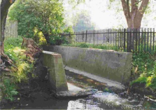
Break river out of concrete channel, re-profile creating natural banks. Replace straightened course of the river with natural meanders. Allow more natural fluvial geomorphological processes to occur and increase habitat. Improved flood alleviation to downstream areas. Integrate with school sports facilities and buildings to provide educational facility for school that could be shared with others. Provide riverside walk to link existing river restorations in Chinbrook Meadows and Sutcliffe Park. Potential for extending the current GREEN CHAIN WALK through Chinbrook Meadows northwards into Greenwich and award winning Sutcliffe Park, alongside a naturalised urban river. Provide natural amenity and green pedestrian walk within urban environment. The Quaggy at this point lies within a straight concrete channel, inside a 6 metre strip enclosed by high fences. The fenced off strip runs through school and private playing fields. As a result the river is extremely degraded with poor aesthetic appeal, is devoid of geomorphological features of interest and has low ecological value. From the upper (southern) end it is possible to walk through largely green space to Chinbrook Meadows and a section of the Green Chain walk where the river was restored in 2002. From the lower (northern) end it is a short distance to Sutcliffe Park where the river was recently restored as part of a flood alleviation scheme. Enhancement would connect these two restored sections for wildlife and people, as well as providing new habitat and a direct educational facility within adjacent school playing fields.
Landowner details:
1. South section: Greenwich council – meadow. Approached and receptive. (Councillor Brian Woodcraft. Ward: Middle Park and Sutcliffe.)
2. Middle section and Left bank: Colfes school – playing fields and fenced off rough ground adjacent to river. Approached in 2005 – not receptive at that time
3. Middle and north section and right bank: Old Brockleians rugby club – playing fields and rough ground adjacent to the river. Approached and receptive. (Ron Tennant, previous president)
4. North section left bank: Possibly or previously Civil Service. Playing fields.
Key themes (Other):
1.) BAP. It will contribute towards the ‘Creating a Better Place’ objective to make proportionate progress towards BAP targets for wetland-related species and habitats’
2.) The works would also fall within the Agency’s duties as set out in the Environment Act 1995 to promote the conservation and enhancement of the natural beauty and amenity of inland and coastal waters and of land associated with such waters.
3) Green Chain Walks – Would create the possibility of extending the green chain walks with a new riverside walk linking the boroughs of Bromley, Lewisham and Greenwich.
Requires the agreement and cooperation of four landowners, including Colfes school. Of these one, Colfes school, was not receptive three years ago when approached in 2005. Sensitivity regarding playing fields, although these do not go right to the edge of the current river course.
Monitoring surveys and results
Lessons learnt
Image gallery
|
Catchment and subcatchmentSelect a catchment/subcatchment
Catchment
Subcatchment
Other case studies in this subcatchment: Lidl, Manor House Gardens, Manor House Gardens Gauging Station, Manor Park, Mottingham Farm, Quaggy Flood Alleviation Scheme, Quaggy channel improvements, River Quaggy- Chinbrook meadows, Sutcliffe Park, Sydenham Cottages Nature Reserve
Site
Project background
Cost for project phases
Reasons for river restoration
Measures
MonitoringHydromorphological quality elements
Biological quality elements
Physico-chemical quality elements
Any other monitoring, e.g. social, economic
Monitoring documents
Additional documents and videos
Additional links and references
Supplementary InformationEdit Supplementary Information
| ||||||||||||||||||||||||||||||||||||||||||||||||||||||||||||||||||||||||||||||||||||||||||||||||||||||||||||||||||||||||||||||||||||||||||||||||||||||||||||||||||||||||||||||||||||||||||||||||||||||||

