Case study:Brackenhurst Natural Flood Management
Project overview
| Status | In progress |
|---|---|
| Project web site | http://www.therrc.co.uk/sites/default/files/projects/25_brackenhurst.pdf |
| Themes | Flood risk management, Habitat and biodiversity, Land use management - agriculture, Land use management - forestry, Monitoring |
| Country | England |
| Main contact forename | Andy |
| Main contact surname | Disney |
| Main contact user ID | |
| Contact organisation | Environment Agency |
| Contact organisation web site | http://www.gov.uk/government/organisations/environment-agency |
| Partner organisations | Nottingham Trent University, Trent Rivers Trust, Southwell Flood Forum, Nottinghamshire County Council |
| Parent multi-site project | |
| This is a parent project encompassing the following projects |
No |
Project summary
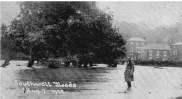
This project is a PhD research project being conducted at Nottingham Trent University by Josh Wells, supervised by Dr Jillian Labadz (Nottingham Trent University) and advised by Andy Disney (Environment Agency) and Professor Colin Thorne (University of Nottingham). It was developed on Nottingham Trent University's Brackenhurst Campus following a summer 2013 extreme flood event in the catchment, which affected the nearby market town of Southwell, immediately downstream (Map 1). A total of 107.6mm of rain fell within a 2-hour period and resulted in the flooding of up to 300 homes.
The aim is to aims assess the extent to which Natural Flood Management (NFM) can help to reduce future fluvial flood occurrence in Southwell. A NFM scheme was developed for the Potwell Dyke catchment (Southwell, Nottinghamshire) as part of the PhD project. In summer 2016, 10 large woody debris dams were installed within the streams. In autumn 2016, a river restoration programme was implemented with the excavation of original meandering stream morphology along a reach plus the provision of some additional online storage capacity and the construction of 5 earth bunds in field corners. These interventions are designed to store and slow water while promoting ecological gains. A network of hydrological monitoring was installed to enable pre and post intervention stage (water level) and rainfall data to be compared. Around a year's worth of pre-intervention stage data have been collected at most locations, with one site being monitored for 2.5 years.
The catchment for the Potwell Dyke is around 6km2. The NFM interventions by Nottingham Trent University are in 2 subcatchments: Springfield Dumble and Parklane Close Dumble.
To date, an estimated 3,000m3 of storage has been created within these subcatchments. There is an intention to roll out further NFM measures on multiple land holdings within the Potwell Dyke catchment. Work is being carried out by Trent Rivers Trust to liaise with local landowners, with funding obtained from the Regional Flood and Coastal Committee.
Monitoring surveys and results
Lessons learnt
Image gallery
|
Catchment and subcatchment
Site
Project background
Cost for project phases
Reasons for river restoration
Measures
MonitoringHydromorphological quality elements
Biological quality elements
Physico-chemical quality elements
Any other monitoring, e.g. social, economic
Monitoring documents
Additional documents and videos
Additional links and references
Supplementary InformationEdit Supplementary Information
| ||||||||||||||||||||||||||||||||||||||||||||||||||||||||||||||||||||||||||||||||||||||||||||||||||||||||||||||||||||||||||||||||||||||||||||||||||||||||||||||||||||||||||||||||||

