Case study:Bocking Blackwater River Restoration
Project overview
| Status | In progress |
|---|---|
| Project web site | http://www.essexrivershub.co.uk |
| Themes | Habitat and biodiversity, Water quality, Urban |
| Country | England |
| Main contact forename | Kieren |
| Main contact surname | Alexander |
| Main contact user ID | User:KierenAlexander |
| Contact organisation | Essex Wildlife Trust |
| Contact organisation web site | http://www.essexwt.org.uk |
| Partner organisations | |
| Parent multi-site project | |
| This is a parent project encompassing the following projects |
No |
Project summary
Currently, the River Blackwater (Pant, upstream) is classed under the Water framework Directive as heavily modified with poor potential. It is this assessment that drives this restoration project. This project is funded by the Environment Agencies Catchment Restoration fund and is part of the Essex Healthy headwaters scheme. Physical earthworks are due to commence in Summer 2015.
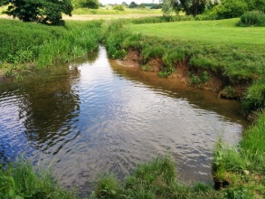
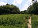
The site is an urban location and is designated as a local nature reserve. It is locally well loved, being popular with walkers, runners and cyclists. A majority of it is close mown grassland, however,there are significant wilder zones in places which are more typical of a Local Nature reserve.
The main aspect of this project is to enhance the river banks by reducing erosion, poaching and silt inputs, the second is to improve riparian habitat and floristic diversity, as an added benefit there should also be an improvement in water quality produced by filtration of the newly established root network.
The river banks will be restored using a mixture of bio engineering schemes including Coir rolls, willow spiling and bank re-profiling combined with Coir pallets. The Coir pallets and roles will be seeded with a combination of native species including flag iris, purple loosestrife and watermint among others. The current condition of the riverbank is floristically poor with either a monoculture of reeds, nettles or the invasive species Himalayan balsam.
Whilst the project is not specifically targeted to deal with invasive species it is hoped that there will be some benefit derived from introducing increased floristic diversity and extra competition.
The final major element of the project is to protect and enhance a deeply eroded section of riverbank. As this is a steep and heavily degraded slope the use of coir rolls and pallets would not be appropriate. Therefore the design solution decided on was to use willow spilling and use the spoil created from the bank reprofiling works to backfill behind the spiling. The idea is then that overtime the willow roots would bind the bank together preventing erosion and offer shading reducing river temperatures in the river over the summer months.
There is some potential to enhance a wetland area, known locally as the spreads by creating a series of ponds and redirecting an existing drain. This will allow any water to be filtered and settled before entering the river. The ponds overtime will develop into fine habitat and support a number of specialist species.
All the above should add up to the an overall improvement of the local Riverine habitat and an improvement in the general water quality and hydro morphological condition of the river.
Increase awareness of flood issues.
Monitoring surveys and results
Fixed point photography will be used to monitor physical changes both post and pre work. In addition a baseline survey of macrophytes, invertebrates and water quality surveys – data gathered will include – turbidity, sediment, Ammonia/Dissolved Oxygen/Phosphate using field phosphate sampling equipment. This project site will be resurveyed against baseline at the conclusion of the project in 2015.
Lessons learnt
There is significant Archaeological interest on the site. With an identified Roman Villa remains in the local area. This adds a significant cost element to the project. Investigations are currently underway to identify the implications for this project but this may make the pond and wetland enhancement uneconomic. Early contact with the local Archaeological unit is recommended.
Image gallery
|
Catchment and subcatchmentSelect a catchment/subcatchment
Catchment
Subcatchment
Site
Project background
Cost for project phases
Reasons for river restoration
Measures
MonitoringHydromorphological quality elements
Biological quality elements
Physico-chemical quality elements
Any other monitoring, e.g. social, economic
Monitoring documents
Additional documents and videos
Additional links and references
Supplementary InformationEdit Supplementary Information
| ||||||||||||||||||||||||||||||||||||||||||||||||||||||||||||||||||||||||||||||||||||||||||||||||||||||||||||||||||||||||||||||||||||||||||||||||||||||||||||||||||||||||||||||||||||||||||||||||


