Case study:Thackthwaite catchment restoration
This case study is pending approval by a RiverWiki administrator.
Project overview
| Status | In progress |
|---|---|
| Project web site | http://https://www.ucmcic.com/projects/natural-flood-management/flood-bank-reprofiling-thackthwaite/ |
| Themes | Environmental flows and water resources, Fisheries, Flood risk management, Habitat and biodiversity, Hydromorphology, Land use management - agriculture, Monitoring, Social benefits, Water quality |
| Country | England |
| Main contact forename | Danny |
| Main contact surname | Teasdale |
| Main contact user ID | User:Ullswater CIC |
| Contact organisation | Ullswater Catchment Management CIC |
| Contact organisation web site | http://www.ucmcic.com |
| Partner organisations | Environment Agency, The National Trust for Places of Historic Interest or Natural Beauty, Natural England, Woodland Trust, Eden Rivers Trust |
| Parent multi-site project | |
| This is a parent project encompassing the following projects |
No |
Project summary
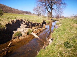
Thackthwaite beck is a heavily modified watercourse. It has been straightened and dredged historically as part of previous land management actions. The beck has failing toe boards, and flood levees in the picture, which shows the extent to which the beck was trying to be retained in. This project began in 2018 to remove the flood levees and reprofile the adjacent land to allow better floodplain reconnection. Thackthwaite beck has a very large upland catchment in the Matterdale area and as such sees very high rainfall annually (2000mm+). The artificial works have been unable to cope with this rainfall and as such are failing.
We are now working with the majority of landowners on this catchment to implement multiple varied improvements to either deliver habitat, river restoration or natural flood management benefits.
To date we have created 25 ponds or wetland areas, made habitat improvements to over 3660m of Thackthwaite beck, through either in stream habitat improvements or riparian improvement, such as floodplain connection or tree planting. We have planted over 100,000 trees in the catchment, either as hedgerows, riparian planting or in field trees.
Ullswater Catchment Management CIC are very proud of the fact that the majority of their work is on farmed land. We actively engage with the farming community and have developed trusted relationships with the farming community. The majority of our work is via invitation on farm to see what is possible.
Monitoring surveys and results
Initial electro-fish survey on Thackthwaite beck prior to levee removal. Results showed low numbers of Salmonids and large numbers of Minnows. This is to be expected as prior to the levee removal the beck was very canalised and could not retain finer material suitable for spawning fish.
Redd counts in autumn to monitor Trout and Salmon spawning success. 2023 was the best year to date for the number of redds, and sightings of Sea Trout and Salmon.
Water quality sondes have been installed by the Environment Agency, these monitor water quality, temperature and turbidity.
Lessons learnt
In our opinion the most valuable lesson learnt is to work with the landowner and be open and honest from the start. By listening to the landowner it helps to understand where the most suitable intervention may be on the watercourse. This is then followed by partner working, by having multiple partners working together it allows an increase in scale of delivery.
Right improvement in the right place. We have seen other individual projects being delivered which do not have the support of neighbouring landowners, and whilst this may return site specific benefits it can often be at the detriment of the wider catchment, as the works can't be replicated close by to build upon the benefits of the initial project.
Image gallery
|
Catchment and subcatchment
Site
Project background
Cost for project phases
Reasons for river restoration
Measures
MonitoringHydromorphological quality elements
Biological quality elements
Physico-chemical quality elements
Any other monitoring, e.g. social, economic
Monitoring documents
Additional documents and videos
Additional links and references
Supplementary InformationEdit Supplementary Information
| ||||||||||||||||||||||||||||||||||||||||||||||||||||||||||||||||||||||||||||||||||||||||||||||||||||||||||||||||||||||||||||||||||||||||||||||||||||||||||||||||||||||||||||||||||

