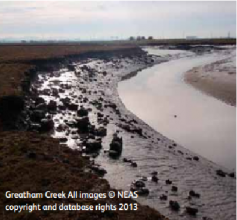
Case study:Greatham Managed Realignment Scheme
This case study is pending approval by a RiverWiki administrator.
Project overview
| Status | Complete |
|---|---|
| Project web site | |
| Themes | Flood risk management, Habitat and biodiversity, Water quality |
| Country | England |
| Main contact forename | environment |
| Main contact surname | agency |
| Main contact user ID | |
| Contact organisation | Environment Agency |
| Contact organisation web site | http://www.ecrr.org/Portals/27/Greatham%20North%20Managed%20Realignment%20Scheme.pdf |
| Partner organisations | natural england; RSPB |
| Parent multi-site project | |
| This is a parent project encompassing the following projects |
No |
Project summary
The Environment Agency identified that the implementation of the Tees Tidal Flood Risk Management strategy would result in in the loss of intertidal habitats which form part of the Teesmouth and Cleveland
Coast Special Protection Area (SPA) and Ramsar site. In addition, the need for further coastal defence works necessary as part of the Redcar Flood Alleviation Scheme also has the potential to cause a loss of SPA habitats.
The Environment Agency therefore had a legal requirement to deliver at least 20 ha of intertidal habitat within the Tees Estuary as compensation for the impact predicted as part of its flood and coastal risk management projects. The Environment Agency purchased 77 ha of land alongside Greatham Creek (part of the Greatham North flood cell) in order to
implement a managed realignment scheme and create the required habitats. The Greatham Managed Realignment Scheme allows future work to the tidal flood defences of the Tees Estuary to continue whilst providing long-term environmental benefit through the conservation of the integrity of the Teesmouth and Cleveland Coast SPA and Ramsar site. The scheme aimed to create a range of complementary habitats of benefit to a variety of wildlife, and ensure better access to for the public was available
Monitoring surveys and results
- The scheme delivered 22 ha of intertidal habitat, comprising a mixture of saltmarsh and mudflats. In addition, other parts of the site delivered areas of saline and brackish water, rough grasslands and coastal and floodplain grassland.
- The borrow pits were restored to provide a minimum of 12 ha of freshwater habitat for species such as great crested newt, common frog and aquatic invertebrates and species rich and meadow grassland.
- No significant adverse impacts to the hydromorphology and sediment regime in the Tees Estuary are expected.
- Features of historic significance, such as salterns (sites historically used for salt making), will be returned to their pre-reclamation situation, reducing current pressures from erosion by burrowing and grazing animals. The regrading of the relic drainage system on site and the location of the breaches were designed, in part, to reduce erosion of the salterns
Lessons learnt
Cumulative benefits can be achieved through undertaking managed realignment schemes for habitat improvements which also form part of the local areas flood defence strategy.
Image gallery
|
Catchment and subcatchmentSelect a catchment/subcatchment
Catchment
Subcatchment
Other case studies in this subcatchment: Greatham Marsh Restoration
Site
Project background
Cost for project phases
Reasons for river restoration
Measures
MonitoringHydromorphological quality elements
Biological quality elements
Physico-chemical quality elements
Any other monitoring, e.g. social, economic
Monitoring documents
Additional documents and videos
Additional links and references
Supplementary InformationEdit Supplementary Information
| ||||||||||||||||||||||||||||||||||||||||||||||||||||||||||||||||||||||||||||||||||||||||||||||||||||||||||||||||||||||||||||||||||||||||||||||||||||||||||||||||||||||||||||||||||||||||||||||||||||||||

