Case study:Saving Chiswick Eyot
Project overview
| Status | In progress |
|---|---|
| Project web site | http://www.savingchiswickeyot.com |
| Themes | Economic aspects, Environmental flows and water resources, Habitat and biodiversity, Hydromorphology, Land use management - forestry, Monitoring, Social benefits, Urban |
| Country | England |
| Main contact forename | Martin |
| Main contact surname | Richardson |
| Main contact user ID | User:Mobilitydream |
| Contact organisation | Natural History Museum |
| Contact organisation web site | http://www.nhm.ac.uk |
| Partner organisations | Royal Holloway University of London, MoLA, University of Leicester, Thames21, Carillion, Port of London Authority, DHI |
| This is a parent project encompassing the following projects |
Project summary
Project team
Dr. Dave Morritt, Royal Holloway University of London. Dr. Paul Clark, Natural History Museum, London. Martin Richardson, PhD student RHUL & NHM.
Project
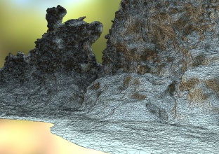
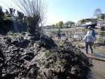
Chiswick Eyot (meaning island) is a small, historically important island in the Thames near Chiswick Mall that is subject to erosion caused in part by burrowing mitten crabs. Crab burrows occur in high densities at the site in excess of 30 per square metre. Individual burrows may be complex structures 70 cm in length and 5 cm in diameter so the amount of soil excavated is significant and the banks of the island are considerably weakened as a result thereby accelerating erosion. We have established an ‘ecosystem’ of partners to address the problem of maintaining the island employing best practice techniques. An initial 3D scan of the entire island was conducted in 2016 in association with the University of Leicester, the Museum of London Archaeology (MoLA), and Leica Geosystems. Subsequent, annual scans will permit calculation of the rate of erosion with analysis of the contribution made by mitten crab burrowing. A conventional topographic survey of part of one bank was undertaken by MoLA in 2000 and this will allow decadal scale assessment of the erosion rate caused by mitten crab burrows. High resolution aerial photographs and digitized historical Ordnance Survey maps are available dating back to at least the 1930s and these will be used to assess migration of the Eyot back and forth across the river, and permit analysis of changes to the island itself in terms of long term erosion. Additional remote sensing and environmental data sets are available and will be used to conduct a 3 dimensional analysis of the area around the Eyot within the context of the Thames catchment as a whole. Ecological changes will be inferred from analysis of the models and verified through species recording data from the NBN. We have engaged the local community and formed partnerships with other organisations including Thames 21, the River Restoration Centre, Leica Geosystems, DHI, MoLA, and Royal Holloway University of London. Additionally we plan to include international partners: the California department of fish and wildlife as well as several international researchers involved in invasive mitten crab work in Poland, Germany, China and elsewhere.
Monitoring surveys and results
The first surveys have been completed. The island has decreased in size by over 40% since the 1930's and there is evidence of correlation with populations of Chinese Mitten crabs burrowing into the banks. The population dynamics of the crabs are characterized by large fluctuations related to environmental factors including temperature and rainfall. Larval development in the Thames requires a residency time of over a month which only occurs when flow rates are low. The burrows are long and wide which means that considerable quantities of sediment are mobilized during excavation but also the damage caused by burrowing is long-lived as the burrows continue to accelerate slumping for several years after the crabs have gone.
A second series of surveys will be conducted over the winter of 2017 and these will be used to assess the current rate of erosion and changes in the morphology of the island.
Lessons learnt
Restoration work using traditional withes (willow saplings) has resulted in accretion to some areas of the bank with development of stabilizing vegetation. However, changes to the flow of the river caused by barriers made of withes have evidently caused some scouring in others, possibly because the barrier is too far from the bottom of bank at these points.
Image gallery
|
Catchment and subcatchmentSelect a catchment/subcatchment
Catchment
Subcatchment
Other case studies in this subcatchment: Barking Creek near A13, Barking Creekmouth, Chambers Wharf, Cuckolds Haven Nature Area, Greenwich Peninsula, Lower River Roding Regeneration Project, Mill Pool, Wandsworth Riverside Quarter
Site
Project background
Cost for project phases
Reasons for river restoration
Measures
MonitoringHydromorphological quality elements
Biological quality elements
Physico-chemical quality elements
Any other monitoring, e.g. social, economic
Monitoring documents
Additional documents and videos
Additional links and references
Supplementary InformationEdit Supplementary Information
| ||||||||||||||||||||||||||||||||||||||||||||||||||||||||||||||||||||||||||||||||||||||||||||||||||||||||||||||||||||||||||||||||||||||||||||||||||||||||||||||||||||||||||||||||||||||||||||||||||||||||


