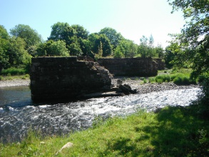
Case study:R Derwent Abutment & Buttress Removal
Jump to navigation
Jump to search
This case study is pending approval by a RiverWiki administrator.
Location: 54° 39' 38.42" N, 3° 28' 49.23" W
Left click to look around in the map, and use the wheel of your mouse to zoom in and out.
Project overview
| Status | Complete |
|---|---|
| Project web site | http://westcumbriariverstrust.org |
| Themes | Hydromorphology |
| Country | England |
| Main contact forename | Ian |
| Main contact surname | Creighton |
| Main contact user ID | |
| Contact organisation | West Cumbria Rivers Trust |
| Contact organisation web site | http://westcumbriariverstrust.org |
| Partner organisations | Environment Agency & Natural England |
| Parent multi-site project | |
| This is a parent project encompassing the following projects |
No |
Project summary
Edit project overview to modify the project summary.
Abandoned railway criss crossed the R Derwent at three locations at this vicinity. The failing abutments and buttresses were removed summer 2013 to improve stream hydrology and morphology.
Monitoring surveys and results
Edit project overview to modify the Monitoring survey and results.
River morphology recovering well. No negative impacts from subsequent major flood events including 'Storm Desmond' December 2015
Lessons learnt
Edit project overview to modify the lessons learnt.
Undertake a Level 2 archaeological survey prior to demolition
Ensure landowners and fishery owners are on board in the early stages
Evaluate likely channel impacts from proposed modifications prior to demolition so no significant supprises
Image gallery
|
Catchment and subcatchment
Site
Project background
Cost for project phases
Reasons for river restoration
Measures
MonitoringHydromorphological quality elements
Biological quality elements
Physico-chemical quality elements
Any other monitoring, e.g. social, economic
Monitoring documents
Additional documents and videos
Additional links and references
Supplementary InformationEdit Supplementary Information
| ||||||||||||||||||||||||||||||||||||||||||||||||||||||||||||||||||||||||||||||||||||||||||||||||||||||||||||||||||||||||||||||||||||||||||||||||||||||||||||||||||||||||||||||||||

