Case study:Aston Clinton River Restoration
This case study is pending approval by a RiverWiki administrator.
Project overview
| Status | Complete |
|---|---|
| Project web site | |
| Themes | Flood risk management, Habitat and biodiversity, Social benefits |
| Country | England |
| Main contact forename | Jessica |
| Main contact surname | Dippie |
| Main contact user ID | User:Jdippie |
| Contact organisation | Buckinghamshire County Council |
| Contact organisation web site | |
| Partner organisations | Environment Agency, Aylesbury Vale District Council, Aston Clinton Parish Council, Green Park |
| Parent multi-site project | |
| This is a parent project encompassing the following projects |
No |
Project summary
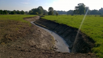
During the winter of 2013/14 there was flooding in Aston Clinton Park, partly as a result of a collapsed culvert. The opportunity was taken to create a new stretch of open watercourse which would bypass the collapsed culvert and was set to benefit the environment, reduce flood risk and be more cost efficient than replacing the very old culvert. The project involved many different stakeholders at different levels of community and council involvement including: the Environment Agency; the tenant farmer; Buckinghamshire County Council, Aylesbury Vale District Council and Aston Clinton Parish Council. The stakeholders worked together by sharing and reducing costs, making use of and blending the skills available within the different organisations and community. The project would have been much more expensive and difficult to achieve without the excellent partnership working demonstrated by all stakeholders. All stakeholders were happy with and proud of the project. The newly cut channel will continue to develop and mature and be a source of pleasure to the community and landowners and benefit to the environment.
Monitoring surveys and results
Ecologists in the Environment Team at Buckinghamshire County Council carried out an initial assessment once the project was complete to establish what life was found in the newly created watercourse. They plan to carry this out annually to see how the river develops and establishes over time.
Lessons learnt
The positive outcome of the river restoration project in Aston Clinton is as a result of great partnership working across all the stakeholders involved. This project really demonstrates that by pooling skills and resources across many organisations and individuals, costs can be reduced and all stakeholders become passionate about achieving an end result that reflects everyone's interests; flood management, biodiversity, ecology, farming and benefitting the community.
Though the project did not run smoothly all the time, this meant that lessons have been learnt regarding project management, especially CDM regulations, early engagement and communication. which can be implemented into future projects and future partnership work.
Image gallery
|
Catchment and subcatchment
Site
Project background
Cost for project phases
Reasons for river restoration
Measures
MonitoringHydromorphological quality elements
Biological quality elements
Physico-chemical quality elements
Any other monitoring, e.g. social, economic
Monitoring documents
Additional documents and videos
Additional links and references
Supplementary InformationEdit Supplementary Information
| ||||||||||||||||||||||||||||||||||||||||||||||||||||||||||||||||||||||||||||||||||||||||||||||||||||||||||||||||||||||||||||||||||||||||||||||||||||||||||||||||||||||||||||||||||


