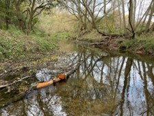
Case study:Papermill Weir Section in-channel restoration
This case study is pending approval by a RiverWiki administrator.
Project overview
| Status | Complete |
|---|---|
| Project web site | |
| Themes | Habitat and biodiversity |
| Country | England |
| Main contact forename | David |
| Main contact surname | Hutchinson |
| Main contact user ID | |
| Contact organisation | Environment Agency |
| Contact organisation web site | http://Environment%20Agency |
| Partner organisations | SKDC, Wild Trout Trust and Grantham Angling Association Fly Fishing Section |
| Parent multi-site project | |
| This is a parent project encompassing the following projects |
No |
Project summary
This project was undertaken to improve river habitat in a section of the Upper Witham downstream of a large weir. Despite flowing through an area of woodland with good riparian wetland habitat and some sinuosity, the bed material was almost exclusively large cobbles. Very little gravel was available for trout spawning, as a result of the interruption of natural sediment transport processes by the weir. In addition, there was little woody material habitat in the river. The project to address this occurred in two phases. In 2022, the Blue Green Corridor project led by SKDC worked in conjunction with Grantham Angling Association (Fly Fishing Section) to hinge existing trees into the river to create berm features and also secured trunks that fully spanned the river. The latter aiming to create scour pools underneath. In 2023, the Wild Trout Trust completed the works by adding gravel onto the sill of the weir at the upstream extent of the reach. In subsequent high flow events, including Storm Babet, the gravel could then naturally start to move into position downstream.
Monitoring surveys and results
This is a routine EA fisheries survey site so we will be able to monitor the long term impact of the changes over the next few years.
Lessons learnt
It has worked well to do this project in two phases, firstly with the addition of the wood and secondly with the gravel. Particularly where living willow has been used, it will allow the woody material to establish before trapping the gravel as it moves downstream over time.
The use of natural wood found on site and the placement of gravel at a single point with good access have proved very cost effective compared to a constructed riffle approach.
If safe to do so, gravel is best added in high flows to avoid the requirement for people in the channel to rake it flat. The high flows will naturally and quickly sort the gravel into position. The gravel used was 5 – 20mm size range; in future a 20 – 40mm component should also be included to match the naturally-occurring size range in the Upper Witham.
Image gallery
|
Catchment and subcatchment
Site
Project background
Cost for project phases
Reasons for river restoration
Measures
MonitoringHydromorphological quality elements
Biological quality elements
Physico-chemical quality elements
Any other monitoring, e.g. social, economic
Monitoring documents
Additional documents and videos
Additional links and references
Supplementary InformationEdit Supplementary Information
| ||||||||||||||||||||||||||||||||||||||||||||||||||||||||||||||||||||||||||||||||||||||||||||||||||||||||||||||||||||||||||||||||||||||||||||||||||||||||||||||||||||||||||||||||||

