Case study:Wyre Riparian Restoration Initiative
Project overview
| Status | Complete |
|---|---|
| Project web site | |
| Themes | Environmental flows and water resources, Fisheries, Flood risk management, Habitat and biodiversity, Hydromorphology, Land use management - agriculture, Monitoring, Water quality |
| Country | England |
| Main contact forename | Thomas |
| Main contact surname | Myerscough |
| Main contact user ID | User:Tom_WRT |
| Contact organisation | Wyre Rivers Trust |
| Contact organisation web site | http://www.wyreriverstrust.org |
| Partner organisations | |
| Parent multi-site project | |
| This is a parent project encompassing the following projects |
No |
Project summary
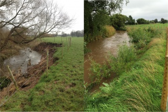
The Wyre Riparian Restoration Initiative has delivered a large riparian restoration scheme on the middle reaches of Woodplumpton Brook. This has been delivered in conjunction with two landowners and covers around 1km of watercourse. A large section of this watercourse was unfenced and significantly affected by the impacts of over grazing, poaching and diffuse pollution. To address these issues, we have installed over 1,150 metres of stock proof fencing, 5 soft engineering solutions and restored an agricultural machinery track which runs through the watercourse. It is expected that this will have a positive impact on the water quality of the brook in this area by reducing the amount of diffuse pollution, sediment and faecal matter which enters the watercourse.
Monitoring surveys and results
Kick Sampling - PSSI, BMWP, ASPT
Fixed Point Photography
River Corridor Surveys
The data which has been collected as part of this project has been the most rigorous of any Wyre Rivers Trust project that has been delivered to date. By engaging the services of two students from Lancaster University we have been able to deliver a considerable of pre project delivery monitoring and we expect that we will be able to engage another student when the project has been delivered therefore allowing us to evaluate the success of our project over the next year. The majority of the data which has been recorded is invertebrate data which has collected using kick sampling, this has been analysed and various indices have been used to interpret it. We were also fortunate to have the use of two Environment Agency SONDES which were installed in June 2015, this data has been recorded and we hope to be able to compare it to SONDE data which will be collected in the summer of 2016. Further to this we have also collected river corridor data and undertaken fixed point photography which will allow us to compare the changes to the watercourse after a season of growth.
Lessons learnt
A number of lessons were learnt from this project, the most important of which was the relative ease with which monitoring data can be collected and used to inform project development and delivery. Where possible WRT and WWCP will now include a monitoring budget in future riparian restoration projects to ensure that similar datasets can be built for other watercourses within the Wyre Catchment.
The project has also allowed WRT and WWCP to build their relationships with a local university. The pre-project monitoring was carried out by a Lancaster University student as part of her Degree course, it is expected that we will be successful in identifying a further student to undertake post project monitoring for a similar period of time to that which was covered initially. The quality of the monitoring which was delivered by the student was very high and ultimately she was highly reliable and required little supervision. This has highlighted the value of working with local universities to us and we will continue to do this in future projects
Image gallery
|
Catchment and subcatchmentSelect a catchment/subcatchment
Catchment
Subcatchment
Site
Project background
Cost for project phases
Reasons for river restoration
Measures
MonitoringHydromorphological quality elements
Biological quality elements
Physico-chemical quality elements
Any other monitoring, e.g. social, economic
Monitoring documents
Additional documents and videos
Additional links and references
Supplementary InformationEdit Supplementary Information
| ||||||||||||||||||||||||||||||||||||||||||||||||||||||||||||||||||||||||||||||||||||||||||||||||||||||||||||||||||||||||||||||||||||||||||||||||||||||||||||||||||||||||||||||||||||||||||||||||||||||||

