Case study:River Cole- Life Project
Project overview
| Status | Complete |
|---|---|
| Project web site | |
| Themes | Flood risk management, Habitat and biodiversity, Hydromorphology, Monitoring, Social benefits |
| Country | England |
| Main contact forename | Martin |
| Main contact surname | Janes |
| Main contact user ID | |
| Contact organisation | River Restoration Centre |
| Contact organisation web site | http://www.therrc.co.uk |
| Partner organisations | Environment Agency, National Trust, Countryside Commission, Natural England |
| Parent multi-site project | |
| This is a parent project encompassing the following projects |
No |
Project summary
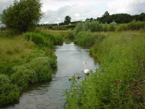
The River Cole at Coleshill is a tributary of the Thames and flows through National Trust owned farmland, North East of Swindon on the Oxfordshire and Wiltshire border.
Already the Domesday Book of 1086 has a record of a mill in Coleshill, and on the earliest map from the area, dated 1666, the river appears to have been straightened. Originally straightened for milling, the section downstream of the mill has more recently been enlarged to safeguard agricultural production from flooding. Upstream the mill was, until the late 1700s, fed by a small artificial channel carrying water from the Cole, but by 1818 the mill leat had been largely extended to take the entire flow of the Cole, and most of the old river course filled in. This type of historical management is typical of many other rural rivers in the United Kingdom.
Upstream of the mill the river was restored to its original course (retaining a small flow in the mill leat) to join the old surviving mill by-pass channel. This new smaller channel encourages beneficial flood storage on the fields and allows fish to pass the mill weir. Downstream the river was reduced in size and remeandered across the old course to a more natural profile, retaining existing mature riverside trees. The restoration of bed level, water level and flood regime was achieved by cutting the new meandering river at a much higher level, similar to that prior to the last major deepening scheme of the 1970s.
Monitoring surveys and results
Lessons learnt
Image gallery
|
Catchment and subcatchmentSelect a catchment/subcatchment
Catchment
Subcatchment
Site
Project background
Cost for project phases
Reasons for river restoration
Measures
MonitoringHydromorphological quality elements
Biological quality elements
Physico-chemical quality elements
Any other monitoring, e.g. social, economic
Monitoring documents
Additional documents and videos
Additional links and references
Supplementary InformationEdit Supplementary Information
| |||||||||||||||||||||||||||||||||||||||||||||||||||||||||||||||||||||||||||||||||||||||||||||||||||||||||||||||||||||||||||||||||||||||||||||||||||||||||||||||||||||||||||||||||||||||||||||||||||||||||||||||||||||


