Case study:Aubourn Rock Ramp and Habitat Works
This case study is pending approval by a RiverWiki administrator.
Project overview
| Status | Complete |
|---|---|
| Project web site | |
| Themes | Fisheries, Habitat and biodiversity |
| Country | England |
| Main contact forename | Matt |
| Main contact surname | Parr |
| Main contact user ID | |
| Contact organisation | Environement Agency |
| Contact organisation web site | http://Environement%20Agency |
| Partner organisations | |
| Parent multi-site project | |
| This is a parent project encompassing the following projects |
No |
Project summary
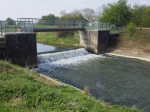
Aubourn Weir, located in the lower reaches of the Upper River Witham, presented a major barrier to upstream fish and eel passage and the heavily-modified channel in the vicinity, lacked morphological and habitat diversity resulting in poor fish populations. Also affected by high levels of phosphates, the overall Ecological Status of this section of the river is classified as Moderate.
The key objectives of the Aubourn project were to enable fish and eel passage at the weir and to undertake additional enhancements to improve the channel diversity. The wider project, from Bassingham Bridge to beyond Aubourn Weir, sought to enhance the heavily-modified channel using existing riverside trees to create in-stream deadwood habitat, improve flow variation and provide valuable refuges for fish and invertebrates.
There were two parts to the project: construction of the rock ramp fish pass and associated bed enhancements in the vicinity of Aubourn Weir, and extensive woody habitat creation from Bassingham downstream to beyond Aubourn Weir.
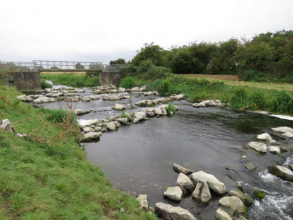
Rock Ramp - Using large rocks and steel sheet piling to maintain the water levels, a series of stepped pools, rising c1m in c20cm increments, were constructed to create the “rock ramp” which now enables fish and eels to negotiate the former obstruction.
Pools – Five pools were excavated in the river bed, three above the new rock ramp and two below it. The excavated material was deposited against the bank immediately upstream of each pool to narrow the channel and speed up the flow - a technique known as “dig-and-dump”.
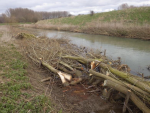
Woody habitat - Riverside trees, in particular those that had collapsed in to the river or were in imminent danger of doing so, were selectively hinged and/or secured into the channel and along the bank throughout the whole of the 3.25km reach. The large woody material creates flow variation and provides refuges for fish and invertebrates as the river level and speed of flow changes.
Monitoring surveys and results
Lessons learnt
Image gallery
|
Catchment and subcatchmentSelect a catchment/subcatchment
Catchment
Subcatchment
Other case studies in this subcatchment: Belton Floodplain Reconnection and River Restoration, Dysart Park, Grantham Habitat Improvement, Grantham Blue Green - Urban Reach, Little Ponton, Manthorpe Floodplain Reconnection, Papermill Weir Section in-channel restoration, River Witham Great Ponton, Stainby Road, Colsterworth, Syston and Barkston Restoration, Upper Cringle Floodplain Restoration Project... further results
Site
Project background
Cost for project phases
Reasons for river restoration
Measures
MonitoringHydromorphological quality elements
Biological quality elements
Physico-chemical quality elements
Any other monitoring, e.g. social, economic
Monitoring documents
Additional documents and videos
Additional links and references
Supplementary InformationEdit Supplementary Information
| ||||||||||||||||||||||||||||||||||||||||||||||||||||||||||||||||||||||||||||||||||||||||||||||||||||||||||||||||||||||||||||||||||||||||||||||||||||||||||||||||||||||||||||||||||||||||||||||||||||||||


