Case study:Slowing the Flow at Pickering
This case study is pending approval by a RiverWiki administrator.
Project overview
| Status | Complete |
|---|---|
| Project web site | http://www.therrc.co.uk/sites/default/files/projects/12_pickering.pdf |
| Themes | Flood risk management, Habitat and biodiversity, Hydromorphology, Land use management - forestry, Monitoring |
| Country | England |
| Main contact forename | Tom |
| Main contact surname | Nisbet |
| Main contact user ID | |
| Contact organisation | Forest Research |
| Contact organisation web site | http://www.forestresearch.gov.uk/ |
| Partner organisations | Defra, Forestry Commission, Environment Agency, North York Moors National Park Authority, Natural England, Durham University, Ryedale Flood Research Group, North Yorkshire County Council, Ryedale District Council, Pickering Town Council, Sinnington Parish Council, North York Moors Railway, Yorkshire Flood and Coastal Committee, Duchy of Lancaster Estates |
| Parent multi-site project | |
| This is a parent project encompassing the following projects |
No |
Project summary
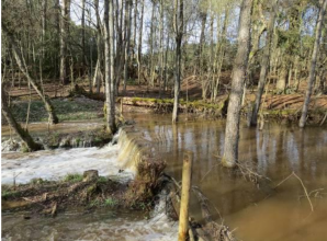
The project was established in April 2009 to look at how changes in land use and land management can help to reduce flood risk for the town of Pickering in North Yorkshire. It was 1 of 3 pilot projects funded by Defra in response to Sir Michael Pitt’s Review of the 2007 floods in England and Wales and his call for greater working with natural processes. The project's overall aim is to demonstrate how the integrated application of a range of land management interventions/measures can help reduce flood risk at the catchment scale, as well as providing wider multiple benefits for local communities. A strong local partnership was formed, which put in place an agreed set of measures designed to reduce the chance of flooding in the town from 25% to 4% or less in any given year. Initial results have been very positive and work continues to evaluate the effectiveness of the measures in reducing flood risk. An analysis of flow measurements from the Boxing Day 2015 storm event, when 50mm of rain fell over a 36-hour period, concluded with a relatively high degree of certainty that the project measures prevented flooding to a small number of properties in the town. It was estimated that the measures reduced the flood peak by 15–20%, with around half of the reduction due to the upstream land management interventions and half due to the large flood storage bund. The results are consistent with other observations that show the measures to be working as expected in reducing flood generation by storing and slowing flood waters within the catchment.
Monitoring surveys and results
Lessons learnt
Image gallery
|
Catchment and subcatchment
Site
Project background
Cost for project phases
Reasons for river restoration
Measures
MonitoringHydromorphological quality elements
Biological quality elements
Physico-chemical quality elements
Any other monitoring, e.g. social, economic
Monitoring documents
Additional documents and videos
Additional links and references
Supplementary InformationEdit Supplementary Information
| ||||||||||||||||||||||||||||||||||||||||||||||||||||||||||||||||||||||||||||||||||||||||||||||||||||||||||||||||||||||||||||||||||||||||||||||||||||||||||||||||||||||||||||||||||

