Case study:Whit Beck River Restoration Project
Project overview
| Status | In progress |
|---|---|
| Project web site | |
| Themes | Environmental flows and water resources, Flood risk management, Habitat and biodiversity, Hydromorphology, Land use management - agriculture, Land use management - forestry |
| Country | England |
| Main contact forename | Ian |
| Main contact surname | Creighton |
| Main contact user ID | User:Ian Creighton |
| Contact organisation | West Cumbria Rivers Trust |
| Contact organisation web site | http://westcumbriariverstrust.org |
| Partner organisations | Environment Agency & Natural England |
| Parent multi-site project | |
| This is a parent project encompassing the following projects |
No |
Project summary
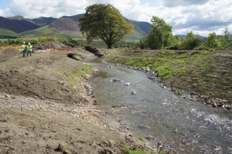
Whit Beck was an ambitious major pilot river restoration project undertaken by West Cumbria Rivers Trust on the behalf of the Environment Agency and Natural England summer 2014. This project was undertaken on Whit Beck, a fast flowing spate tributary of the River Cocker (River Derwent SSSI) in the English Lake District. A 350m section of heavily modified raised river channel was successfully diverted to natural self-sustainable diverse watercourse.
The benefits include:
• Restoration of natural river processes and associated features (WFD requirement)
• Increase in stream length (over 3 fold - 1205m) and channel area (4/5 fold)
• Provision of a wider range of habitats enabling fish to carry out the various stages of their life cycles within the new reach
• Significantly improvement in floodplain connectivity (flood storage)
• Increased in channel storage for gravels
• The provision of wildlife corridors (plants, insects and animals)
• Increased flood proofing for fish redds
• New deciduous woodlands and woodland strips
• Enhanced landscape
There were four parties with a vested interest in Whit Beck, two farmers, one tenant and an independent landowner. The scheme was entirely voluntary and all parties had to be on board for the project to get off the ground and succeed. It took two years of planning, investigations and engineering to complete. The total cost over the life of the project is in the vicinity of £700k. Construction was completed by the end of September 2014.
Monitoring surveys and results
Monitoring being undertaken in partnership with Aberystwyth University - preliminary results not be available until late 2015
Lessons learnt
• Need for guaranteed funding over the life of the project (year to year) – possible delays
• The need to be flexible, projects drop out (cost implication) prior to agreements being signed
• Need to confirm ownership and vested interest in land (e.g. pension fund / banks / trusts etc)
• Valley bottom land is vital for the farming business to succeed in upland areas
• Complications caused by multiple landowners – e.g. access provision (cost implications)
• Still belief in farming community that the continued maintenance of watercourses are vital
• Agricultural schemes can be inflexible and can result in increased costs & complexity
• Disturbance payments may be necessary as a form of inducement and to cover period of construction and recovery (short and long term losses)
• Need to comply with State Aid rules
• Constraints and compromises – they will significantly affect the detailed design (e.g. agreeing route of new channel with landowners, footpath temporary closures / re-routing etc)
• Question of liability for new channel once handed back to landowner
• Scale of engineering required in new channel design and at point of break out
• The need for sufficient mixed bed substrate to enable natural processes to sort and deposit
• The necessity for appropriate land licence agreements and construction contracts to protect all parties
• Planning permission (National Park) – could be significant delay and is an additional cost
• Flood risk (significant flooding in 2005 and 2009) – may require detailed flood risk assessment and associated public consultation (takes time)
• Weather conditions during construction (delays) and land area required for de-watering (potentially additional costs and risk)
• Commuted sum required for new bridge construction under roads
• Demand for public access to site once scheme completed
• Need for future monitoring (harder to secure funding for)
• Need a means to access funding for any unforeseen future liabilities
Image gallery
|
Catchment and subcatchmentSelect a catchment/subcatchment
Catchment
Subcatchment
Other case studies in this subcatchment: Cumbria River Restoration Program - Whitbeck restoration project - West Cumbria
Site
Project background
Cost for project phases
Reasons for river restoration
Measures
MonitoringHydromorphological quality elements
Biological quality elements
Physico-chemical quality elements
Any other monitoring, e.g. social, economic
Monitoring documents
Additional documents and videos
Additional links and references
Supplementary InformationEdit Supplementary Information
| ||||||||||||||||||||||||||||||||||||||||||||||||||||||||||||||||||||||||||||||||||||||||||||||||||||||||||||||||||||||||||||||||||||||||||||||||||||||||||||||||||||||||||||||||||||||||||||||


