Case study:MisbourneRiverAction
This case study is pending approval by a RiverWiki administrator.
Project overview
| Status | In progress |
|---|---|
| Project web site | |
| Themes | Environmental flows and water resources, Flood risk management, Habitat and biodiversity, Monitoring, Social benefits, Water quality |
| Country | England |
| Main contact forename | Bob |
| Main contact surname | Older |
| Main contact user ID | |
| Contact organisation | local volunteer and community groups |
| Contact organisation web site | http://www.misbourneriveraction.org |
| Partner organisations | Chalfont St Peter & St Giles Parish Councils; Chiltern Society; Chiltern Conservation Board |
| Parent multi-site project | |
| This is a parent project encompassing the following projects |
No |
Project summary
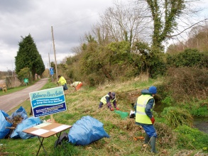
We are a friendly, very informal and sociable network with a common interest in improving the river environment, mainly working downstream of Amersham and through Chalfont St Giles and St Peter although very much involved in groundwater and invertebrates studies along the full length. Our goals are to see the river flowing freely, the channel cleared and maintained in an environmentally friendly way and the river corridor free of litter.
We started our work in 2008 and made good steady progress all the way through to late summer 2011 when the many months of well below average rainfall caused an irresistible retreat of the river back above Chalfont St Giles. The last three years have been very successful with good flows for much of the time. We work closely with the Chiltern Conservation Board, the Parish Councils, Affinity Water and others to preserve and enhance the river environment in the longer term and with greater reliability of flow. We have undertaken numerous working parties to remove debris and undergrowth and generally ease and optimise the flow. We have secured interest and support for these aims through various publicity and involvement with, for instance, the Parish Councils, Chalfont St Peter Feast Day and Chalfont St Giles Fair. Rotary Club, The Scouts and schools. We don’t have meetings or “officers” but occasionally some of us gather for a chat - we call them " not-a-meetings" - in a pub. Regular, “organised” work parties happen on Sundays, sometimes Saturdays, every 5 weeks or so, while others prefer to meet up during the week or just to work on their own when the fancy takes them. Some people have volunteered to “adopt” a short stretch of river. We do have insurance, some tools, gloves, hi-vis, waders and use of a trailer. Our "membership" includes a delightful mix of people from ages 7 to 70(+).
Working with us involves giving up an hour or several, frequently or occasionally, to get dirty, often wet, sometimes scratched (brambles) or stung (nettles). Our e-mail circular goes to over 200 homes representing 300 supporters but, typically, a work day will see around twenty. We don't "require" any commitment - some people come for an hour once a year; some work for hours at almost every opportunity, and some are happy to support us from the sidelines or do the occasional litter pick. Recent circular e-mails can be found under "From the Riverbank" on the website - www.misbourneriveraction.org - where they are archived along with lots of other river stuff .
Monitoring surveys and results
See: http://www.misbourneriveraction.org/node/18 , http://www.misbourneriveraction.org/node/20 , etc
Lessons learnt
Image gallery
|
Catchment and subcatchmentSelect a catchment/subcatchment
Catchment
Subcatchment
Site
Project background
Cost for project phases
Reasons for river restoration
Measures
MonitoringHydromorphological quality elements
Biological quality elements
Physico-chemical quality elements
Any other monitoring, e.g. social, economic
Monitoring documents
Additional documents and videos
Additional links and references
Supplementary InformationEdit Supplementary Information
| ||||||||||||||||||||||||||||||||||||||||||||||||||||||||||||||||||||||||||||||||||||||||||||||||||||||||||||||||||||||||||||||||||||||||||||||||||||||||||||||||||||||||||||||||||||||||||||||||||||||||

