Case study:Welland for People and Wildlife Project
Project overview
| Status | Complete |
|---|---|
| Project web site | http://http://www.wellandpeoplewildlife.org.uk/ |
| Themes | Environmental flows and water resources, Flood risk management, Habitat and biodiversity, Hydromorphology, Monitoring, Social benefits, Water quality, Urban |
| Country | England |
| Main contact forename | Peter |
| Main contact surname | Barham |
| Main contact user ID | |
| Contact organisation | Welland Rivers Trust |
| Contact organisation web site | http://www.wellandriverstrust.org.uk/ |
| Partner organisations | Environment Agency; Defra; University of Leicester; Harborough District Council; Welland Valley Partnership |
| Parent multi-site project | |
| This is a parent project encompassing the following projects |
No |
Project summary
The Welland for People and Wildlife is a partnership project that will use CRF funds to restore 1.8km of the River Welland and its tributary the River Jordan, as they run through Market Harborough, Leicestershire.
This project exists to turn the eyesore the River Welland has become into a central cultural feature, improving biodiversity, water quality and Water Framework Directive status.
The Welland for People and Wildlife project strives to restore the River Welland through Market Harborough to a more natural form correcting the unsympathetic flood alleviation works which were carried out in the 1970s. This project aims to remove barriers to fish migration and improve community value without compromising flood defence.
The outcomes of the project are: 1.The return to near natural flow regimes of riffles and pools alternating in a new low flow channel. 2.Habitat restoration via the return of a natural mosaic of biotopes in riffles, pools, runs and bars 3.Biodiversity via the increase in species as a result of improved habitat diversity 4.Social and cultural benefits by recreating a recreational and educational environment for the people of the town 5.Water quality, as the biotope diversity will increase the ecological processes of the river, such as nutrient uptake 6.Ecosystem services (as a consequence of all the above)
Monitoring surveys and results
Quality of habitats
An environment must provide idyllic conditions for the persistence of vegetation and wildlife. The restoration has delivered clearer water, with better oxygenation, and improved flow preventing silt build-ups and stagnation. There is more riparian space, allowing habitats to expand and communities to mature. Due to the partnership with the EA through their fish passage project, all impoundments to fish and eel movements have been removed, allowing free passage and mixing of populations for the entire project reach.
In addition, shallower riffled areas have become ideal for fish spawning; total number of areas suitable for spawning has increased from 12 to 52. 40 of these have been observed as actively used for spawning by Sticklebacks, Minnow, Chub and Dace.
Ongoing sampling will determine how much of an ecological recovery the river has made towards a more natural state. The objective of ‘Improving the habitats’ is considered fulfilled, however this will be an ongoing improvement as the restoration works mature.
Biodiversity
Both marginal and emergent plants have thrived. Varieties are more diverse and abundant along the water’s edge. Surveys show the previously 2 dominant species have been reduced, and now there are 10 prevailing species. Several species have naturally returned indicating the environment is now more favourable to support diverse aquatic life.
There has been an increase in the diversity of fish species; however decreases in total catch numbers and decrease in body size. With the barrier removal, the fish are no longer restricted and so have spread into the newly opened areas. Fish (and eels) have been seen further upstream than before, and in large numbers. Trout are freely able to connect with upstream wild populations. However, during surveys of the restored reach, fewer numbers are caught – this is thought to be due to 2 factors; 1) space - weirs before created a ‘catching fish in a barrel’ scenario, 2) predators – Otters have been frequently using the restored river to fish, and are thought to have a holt nearby.
There has been an increase in species richness of aquatic macroinvertebrates. Particular improvement is seen in the riffle habitat where diversity, abundance and biomass have increased for aquatic macroinvertebrates.
There is now a much wider variety of habitats. The original 4 dominant habitats types have been reduced or replaced with other key varieties, giving a total of 13 types. Homogenous stretches where 1 or 2 habitats dominated have been replaced with multiple types of habitat, distributed more evenly between types. In addition, there has been a decrease in the less beneficial habitats (for metabolic rate processing) of cobble, emergent and boulder, with an increase in valuable marginal, submerged, algae and woody material habitats.
There has been an average increase of 1.6mg/l/s-1 of oxygen within the restored reach. This is due to an increase in photosynthesis and a decrease in the sediment oxygen demand.
The objective of ‘Increasing the biodiversity of the river Welland through Market Harborough’ is considered part achieved, but study is ongoing for a 5-year period to thoroughly assess the impact.
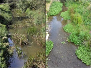
Flow diversity The flow seen across the whole project reach has diversified. The removal of weirs and insertion of riffle-pool habitat has led to a replacement of stagnated monotonous flow with fast paced riffles and slow gentle pools. Water clarity has improved due to a reduction in the stagnation effect. Stagnation before the works had led to suspended sediment dropping out behind weirs, and encouraging weed growth across the channel. The works creating a continuous flow has removed this issue, and reduced monoculture weed choking the channel. Similarly, measures taken to reduce erosion risk (coir matting, gravel topping, planting and woody lattice deflectors) have led to a reduction in sediment lost in the reach, resulting in clearer water. The objective of ‘reducing the stagnation and sluggish flow of the river’ is considered fulfilled but study is ongoing to assess the geomorphological response. Visual aesthetics Before works the river was deep-sided, stagnant, muddy watered ditch. Now the river is clear, diversely flowing channel with shallowed margins abundant with variety of flowering and non-flowering aquatic plants. Birds have become more conspicuous users of the river. Common birds are seen bathing and hunting insects from the surface. Birds such as Grey Wagtail have increased in abundance, including the number of breeding pairs. Kingfishers have been sighted frequently, nesting in some of the uncovered banks, and hunting in the now clear shallow waters. Otters have also been frequent users of the river, enjoying the improved fishing, and easy access into and out of the river. All these aspects have led to positive and complimentary feedback from individuals and community groups concerning the visual transformation of the river. Community use and interaction Community involvement during the design stages and a subsequent sense of community ownership was seen as a key goal for project success. Multiple evening discussion and group meetings drew gatherings between 50-150 people. Physical activities were also popular, attracting between 8-40 people, and a Bioblitz drew hundreds of visitors over 24 hours. Wildlife watching groups have formed for the local Kingfishers, Otters and general wildlife with Facebook pages to post images and updates. The river is now widely regarded as an amenity to preserve, evidenced by maintenance promises offered by community groups, including regular river litter picks. Landowners for every section of the river also agreed by contract to maintain the upkeep of the restored river as required. Nine primary schools have been involved in pond dipping and river lessons; also a secondary school has been involved through assembly demonstrations and presentations. Two Scouting groups have taken part in wildlife walks, bird box building and painting. The use of the river for educational purposes will continue - with easier and safer access to the river installed throughout the Town. Groups and individuals are able to access the river without difficulty, demonstrated by more children using the river to play post restoration works.
Lessons learnt
A lack of flexibility in the consents meant that a design needed to be rigid before continuation. A better understanding of what is needed from a third party with such limitations in money, availability and future maintenance and accountability would have avoided this issue. To ensure success, we engaged geotechnical services in the design process. Although our evidence was clear from surveys, we needed additional agreement of civil engineers for the EA to be confident our design was appropriate.
Weather was an issue as rain meant rapid water level rises due to the large run-off volumes in the urban area. In addition, numerous weir structures held back large quantities of water. To overcome this, the weir boards were demolished first to allow a free flow of water, and drain the excess ponded areas within reach. Despite a headwater, without first removing the weirs, the water and silt deposits were too deep for safe working.
Working in an urban environment was a challenge due to the surrounding infrastructure and cables. Designs had to be flexible to ensure adjustments to account for this. In addition, there were many landowners (40 individuals) to track down and discuss access and maintenance agreements.
Image gallery
|
Catchment and subcatchmentSelect a catchment/subcatchment
Catchment
Subcatchment
Other case studies in this subcatchment: Drayton
Site
Project background
Cost for project phases
Reasons for river restoration
Measures
MonitoringHydromorphological quality elements
Biological quality elements
Physico-chemical quality elements
Any other monitoring, e.g. social, economic
Monitoring documents
Additional documents and videos
Additional links and references
Supplementary InformationEdit Supplementary Information
| |||||||||||||||||||||||||||||||||||||||||||||||||||||||||||||||||||||||||||||||||||||||||||||||||||||||||||||||||||||||||||||||||||||||||||||||||||||||||||||||||||||||||||||||||||||||||||||||||||||||||||||||||||||||||||||||||||||||||||||||||||||||||||||||||||||||||||||||||||||||||||||||||||||||||||||||||||||||||||


