Case study:River Cole- Life Project
Project overview
| Status | Complete |
|---|---|
| Project web site | |
| Themes | Flood risk management, Habitat and biodiversity, Hydromorphology, Water quality |
| Country | England |
| Main contact forename | Martin |
| Main contact surname | Janes |
| Main contact user ID | User:NickRRC |
| Contact organisation | River Restoration Centre |
| Contact organisation web site | http://www.therrc.co.uk |
| Partner organisations | Environment Agency, National Trust, Countryside Commission, English Nature |
| Parent multi-site project | |
| This is a parent project encompassing the following projects |
No |
Project summary
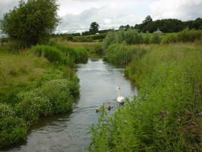
The river Cole has been realigned, straightened, and enlarged for over 900 years. Originally straightened for milling, the downstream section has more recently been enlarged to safeguard agricultural production from flooding. Above the mill the channel was realigned 200 to 300 years ago to form the present mill leat. This type of historical management is typical of many other rural rivers in the United Kingdom.
Upstream of the mill the river was restored to its original course (retaining a small flow in the mill leat) to join the old surviving mill by-pass channel. This new smaller channel encourages beneficial flood storage on the fields and allows fish to pass the mill weir. Downstream the river was reduced in size and remeandered across the old course to a more natural profile, retaining existing mature riverside trees. The restoration of bed level, water level and flood regime was achieved by cutting the new meandering river at a much higher level, similar to that prior to the last major deepening scheme of the 1970s.
Monitoring surveys and results
Lessons learnt
Catchment and subcatchment
Edit the catchment and subcatchment details
(affects all case studies in this subcatchment)
Catchment
| River basin district | |
|---|---|
| River basin | Humber |
Subcatchment
| River name | River Cole |
|---|---|
| Area category | |
| Area (km2) | |
| Maximum altitude category | |
| Maximum altitude (m) | |
| Dominant geology | |
| Ecoregion | |
| Dominant land cover | |
| Waterbody ID |
Other case studies in this subcatchment: The River Cole and Tyseley Energy Park: Creation of Community Commons
Site
| Name | River Cole |
|---|---|
| WFD water body codes | GB106039023730 |
| WFD (national) typology | |
| WFD water body name | Cole (Bower Bridge to Thames) including Coleshill |
| Pre-project morphology | Straight, Single channel |
| Reference morphology | Sinuous |
| Desired post project morphology | |
| Heavily modified water body | Yes |
| National/international site designation | |
| Local/regional site designations | |
| Protected species present | No |
| Invasive species present | No |
| Species of interest | |
| Dominant hydrology | |
| Dominant substrate | Bedrock, Boulders, Gravel |
| River corridor land use | Extensive agriculture |
| Average bankfull channel width category | 2 - 5 m |
| Average bankfull channel width (m) | |
| Average bankfull channel depth category | 0.5 - 2 m |
| Average bankfull channel depth (m) | |
| Mean discharge category | |
| Mean annual discharge (m3/s) | |
| Average channel gradient category | |
| Average channel gradient | 0.0008 |
| Average unit stream power (W/m2) |
Project background
| Reach length directly affected (m) | 2000 m2 km <br />200,000 cm <br /> |
|---|---|
| Project started | 1996/08/01 |
| Works started | |
| Works completed | |
| Project completed | 1996/12/31 |
| Total cost category | 100 - 500 k€ |
| Total cost (k€) | 175 k€175,000 € <br /> |
| Benefit to cost ratio | |
| Funding sources |
Cost for project phases
| Phase | cost category | cost exact (k€) | Lead organisation | Contact forename | Contact surname |
|---|---|---|---|---|---|
| Investigation and design | |||||
| Stakeholder engagement and communication | |||||
| Works and works supervision | |||||
| Post-project management and maintenance | |||||
| Monitoring |
Reasons for river restoration
Measures
Structural measures
| |
|---|---|
| Bank/bed modifications | Planting, Depth modification |
| Floodplain / River corridor | Floodplain spillways |
| Planform / Channel pattern | Introduction of sinuosity, Creation of secondary channel, Backwaters created |
| Other | Livestock access, New crossings |
Non-structural measures
| |
| Management interventions | |
| Social measures (incl. engagement) | |
| Other | |
Monitoring
Hydromorphological quality elements
| Element | When monitored | Type of monitoring | Control site used | Result | ||
|---|---|---|---|---|---|---|
| Before measures | After measures | Qualitative | Quantitative | |||
Biological quality elements
| Element | When monitored | Type of monitoring | Control site used | Result | ||
|---|---|---|---|---|---|---|
| Before measures | After measures | Qualitative | Quantitative | |||
| Invertebrates | Yes | Yes | Yes | Improvement | ||
| Fish: Species composition | Yes | Yes | Yes | |||
Physico-chemical quality elements
| Element | When monitored | Type of monitoring | Control site used | Result | ||
|---|---|---|---|---|---|---|
| Before measures | After measures | Qualitative | Quantitative | |||
Any other monitoring, e.g. social, economic
| Element | When monitored | Type of monitoring | Control site used | Result | ||
|---|---|---|---|---|---|---|
| Before measures | After measures | Qualitative | Quantitative | |||
| Public perceptions | No | Yes | Yes | No | No | Improvement |
Monitoring documents
Image gallery
Additional documents and videos
Additional links and references
| Link | Description |
|---|---|
| http://www.therrc.co.uk/case studies/cole brochure.pdf | River Restoration Centre Case Study |


