Case study:Nine Chalk Rivers Project
Project overview
| Status | In progress |
|---|---|
| Project web site | http://www.norfolkriverstrust.org/p/river-stiffkey-restoration-plan.html |
| Themes | Fisheries, Flood risk management, Habitat and biodiversity, Water quality |
| Country | England |
| Main contact forename | Jonah |
| Main contact surname | Tosney |
| Main contact user ID | |
| Contact organisation | Norfolk Rivers Trust |
| Contact organisation web site | http://www.norfolkriverstrust.org |
| Partner organisations | private landowners, Environment Agency, Natural England, Norfolk Wildlife Trust, The University of East Anglia, RSPB, The Wild Trout Trust, The River Glaven Conservation Group, Norfolk Coast AONB |
| This is a parent project encompassing the following projects |
Nine Chalk Rivers Project - Babingley Catchment, Nine Chalk Rivers Project - Burn Catchment, Nine Chalk Rivers Project - Gaywood Catchment, Nine Chalk Rivers Project - Glaven Catchment, Nine Chalk Rivers Project - Heacham Catchment, Nine Chalk Rivers Project - Hun Catchment, Nine Chalk Rivers Project - Ingol Catchment, Nine Chalk Rivers Project - Mun Catchment, Nine Chalk Rivers Project - Stiffkey Catchment |
Project summary
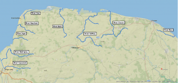
The Nine Chalk Rivers project is a series of 16 restoration projects spread across nine unique chalk rivers flowing onto Norfolk’s north coast. The rivers face similar problems, most notably canalisation, disconnection from the floodplain, siltation, low flows and diffuse pollution. The projects are diverse, and include re-meandering, floodplain re-connection, silt and nutrient trapping and catchment management planning. Each project will improve the ecological health of the rivers and floodplains.
To deliver these projects, Norfolk Rivers Trust is working with landowners across Norfolk as well as the Environment Agency, Natural England, The University of East Anglia, Norfolk Wildlife Trust, Norfolk Coast AONB, RSPB, The Wild Trout Trust, The River Glaven Conservation Group and various other partners.
Background to the project The Norfolk River's Trust, The Norfolk Coast Partnership and Norfolk County Council put in a project bid to the Environment Agency Catchment Restoration Fund to look at improving 9 of Norfolk's chalk rivers. £1.3M was awarded towards the end of 2012. This is one of the largest of the awarded Environment Agency projects in the Country. The project involves practical on the ground river restoration work so some physical changes to the rivers will be seen relatively quickly.
The partnership Steering Group (Norfolk Coast Partnership, Norfolk Rivers Trust, Norfolk County Council, Environment Agency and the Norfolk Wildlife Trust) along with statutory organisations and local communities will guide the Nine Chalk Rivers Project.
The rivers include the Glaven, Stiffkey, Babingley, Gaywood, Hun, Mun, Ingol, Heacham and Burn. To begin with work will start on the Glaven, Stiffkey, Babingley and Gaywood and then it is hoped that further funding can be attained for the other 5 smaller rivers.
Description of Works
- Restoring hydrology – re-creating meanders in straightened rivers improves sediment transport and habitat diversity for fish and invertebrates, while re-connecting rivers to floodplains buffers flows, improves floodplain habitats for plants, insects and birds, prevents siltation and improves water quality.
- Silt trapping – trapping silt close to its source prevents it from smothering riverine habitats and allows farmers to re-use nutrient rich top-soils.
- Community Involvement – Norfolk Rivers Trust is involving communities in catchment management planning and project delivery through local conservation groups, community councils and stakeholder workshops.
How you can help The long term aim is to create local groups that will take over management when the grant cash runs out. Local community support is crucial to the understanding of these rivers, therefore we want your views of the rivers. Where and what are the problems? What would make your local river function better? What would you like to see happen and how would you like to be involved?
Find out more
You can find regular updates as to what is happening on Twitter @9ChalkRivers or if you want to get involved you can contact the Community Involvement Officer by email gemma.clark@norfolk.gov.uk by telephone on 01553 778024 or by mobile on 07768 031629 your ideas and thoughts are really valued so please do not hesitate to contact us.
Monitoring surveys and results
What will success look like?
Delivery of these projects will represent a significant step in the restoration of these nine unique rivers and will contribute towards improvements in Water Framework Directive classifications. Enabling the rivers to function naturally will improve habitat for plants and animals both in the river and on the floodplain, including trout, eels, native crayfish, water-voles, wet-meadow flora such as marsh marigold, and birds such as lapwings, snipe and avocet.
Lessons learnt
Image gallery
|
Catchment and subcatchmentSelect a catchment/subcatchment
Catchment
Subcatchment
Other case studies in this subcatchment: Nine Chalk Rivers Project - Stiffkey Catchment
Site
Project background
Cost for project phases
Supplementary funding informationthere will also be match funding
Reasons for river restoration
Measures
MonitoringHydromorphological quality elements
Biological quality elements
Physico-chemical quality elements
Any other monitoring, e.g. social, economic
Monitoring documents
Additional documents and videos
Additional links and references
Supplementary InformationEdit Supplementary Information
| ||||||||||||||||||||||||||||||||||||||||||||||||||||||||||||||||||||||||||||||||||||||||||||||||||||||||||||||||||||||||||||||||||||||||||||||||||||||||||||||||||||||||||||||||||||||||||||||||||||||||


