Case study:Borrowash fish pass: Difference between revisions
No edit summary |
No edit summary |
||
| Line 38: | Line 38: | ||
{{Project background | {{Project background | ||
|Reach length directly affected=85 | |Reach length directly affected=85 | ||
|Project started=2012/01/02 | |||
|Project completed=2012/09/21 | |||
|Total1 cost=770 | |Total1 cost=770 | ||
|Funding sources=The Environment Agency, | |Funding sources=The Environment Agency, | ||
Revision as of 10:46, 30 January 2013
Project overview
| Status | Complete |
|---|---|
| Project web site | |
| Themes | Fisheries |
| Country | England |
| Main contact forename | Jim |
| Main contact surname | Finnegan |
| Main contact user ID | User:NickRRC |
| Contact organisation | Environment Agency |
| Contact organisation web site | http://www.environment-agency.gov.uk/news/143012.aspx |
| Partner organisations | |
| Parent multi-site project | |
| This is a parent project encompassing the following projects |
No |
Project summary
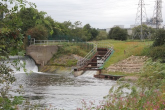
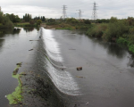
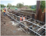
Borrowash fish pass is the largest in the Midlands region to date. It is located at Borrowash on the River Derwent, a major tributary of the River Trent in Derbyshire. In total it took twelve months to complete the 2.7m wide three stage Larinier design at a total cost of £650,000.
The overall aim was to increase fish passage, by enabling access to habitats both up and downstream of the weir. This project is part of a wider range of fish passage improvements planned for the East Midlands region, as restrictions to free fish passage are now seen as the main factor limiting fish stocks within the Trent catchment. There are currently nine proposed sites including Church Wilne and Whatstandwell gauging weirs. Partners involved include the Environment Agency, the Trent Rivers Trust and Derby County Council, as well as local angling clubs and the local community. The long term aim of this catchment scale project is to improve the river’s status under the Water Framework Directive.
The Borrowash pass is the first artificial barrier on the River Derwent, and therefore of strategic importance to improve longitudinal connectivity for fish, sediment, invertebrates and nutrients within the catchment. In 2010 salmon were seen on the Derwent for the first time in 200 years, however the pass will also benefit other species specifically brown trout, chub, dace, minnows, eels and lamprey . Boosting fish stocks will also improve angling opportunities in the local area.
The River Restoration Centre would like to thank the Environment Agency for providing the information and photographs for this case study.
Monitoring surveys and results
Lessons learnt
Catchment and subcatchment
Edit the catchment and subcatchment details
(affects all case studies in this subcatchment)
Site
| Name | Borrowash |
|---|---|
| WFD water body codes | |
| WFD (national) typology | |
| WFD water body name | |
| Pre-project morphology | |
| Reference morphology | |
| Desired post project morphology | |
| Heavily modified water body | No |
| National/international site designation | |
| Local/regional site designations | |
| Protected species present | No |
| Invasive species present | No |
| Species of interest | Salmon, Brown trout |
| Dominant hydrology | |
| Dominant substrate | |
| River corridor land use | Urban, Intensive agriculture (arable), Broadleaf/mixed woodland (semi natural) |
| Average bankfull channel width category | |
| Average bankfull channel width (m) | |
| Average bankfull channel depth category | |
| Average bankfull channel depth (m) | |
| Mean discharge category | |
| Mean annual discharge (m3/s) | |
| Average channel gradient category | |
| Average channel gradient | |
| Average unit stream power (W/m2) |
Project background
| Reach length directly affected (m) | 8585 m <br />0.085 km <br />8,500 cm <br /> |
|---|---|
| Project started | 2012/01/02 |
| Works started | |
| Works completed | |
| Project completed | 2012/09/21 |
| Total cost category | |
| Total cost (k€) | 770770 k€ <br />770,000 € <br /> |
| Benefit to cost ratio | |
| Funding sources | The Environment Agency |
Cost for project phases
| Phase | cost category | cost exact (k€) | Lead organisation | Contact forename | Contact surname |
|---|---|---|---|---|---|
| Investigation and design | |||||
| Stakeholder engagement and communication | |||||
| Works and works supervision | |||||
| Post-project management and maintenance | |||||
| Monitoring |
Reasons for river restoration
| Mitigation of a pressure | Impoundments (not hydropower) |
|---|---|
| Hydromorphology | |
| Biology | |
| Physico-chemical | |
| Other reasons for the project |
Measures
Structural measures
| |
|---|---|
| Bank/bed modifications | Larinier fish pass |
| Floodplain / River corridor | |
| Planform / Channel pattern | |
| Other | |
Non-structural measures
| |
| Management interventions | |
| Social measures (incl. engagement) | |
| Other | |
Monitoring
Hydromorphological quality elements
| Element | When monitored | Type of monitoring | Control site used | Result | ||
|---|---|---|---|---|---|---|
| Before measures | After measures | Qualitative | Quantitative | |||
Biological quality elements
| Element | When monitored | Type of monitoring | Control site used | Result | ||
|---|---|---|---|---|---|---|
| Before measures | After measures | Qualitative | Quantitative | |||
Physico-chemical quality elements
| Element | When monitored | Type of monitoring | Control site used | Result | ||
|---|---|---|---|---|---|---|
| Before measures | After measures | Qualitative | Quantitative | |||
Any other monitoring, e.g. social, economic
| Element | When monitored | Type of monitoring | Control site used | Result | ||
|---|---|---|---|---|---|---|
| Before measures | After measures | Qualitative | Quantitative | |||
Monitoring documents
Image gallery
Additional documents and videos
Additional links and references
| Link | Description |
|---|
Supplementary Information
Edit Supplementary Information


