Case study:Greatham Marsh Restoration: Difference between revisions
No edit summary |
No edit summary |
||
| Line 33: | Line 33: | ||
*Biodiversity River Units | *Biodiversity River Units | ||
Biodiversity Area Units – including intertidal habitats and with unrestricted inland migration | *Biodiversity Area Units – including intertidal habitats and with unrestricted inland migration | ||
Nutrient reduction in Tees catchment subject to Nutrient Neutrality advice from NE | *Nutrient reduction in Tees catchment subject to Nutrient Neutrality advice from NE | ||
Climate change through reduced operational carbon emissions and sequestration in habitat | *Climate change through reduced operational carbon emissions and sequestration in habitat | ||
SPA SSSI improvement – unfavourable declining SSSI Unit die to excess nutrients, SPA objectives to reduce nutrients and restore extend intertidal habitats | *SPA SSSI improvement – unfavourable declining SSSI Unit die to excess nutrients, SPA objectives to reduce nutrients and restore extend intertidal habitats | ||
Nature based solution through increased river channel capacity | Nature based solution through increased river channel capacity | ||
Latest revision as of 14:29, 10 December 2024
This case study is pending approval by a RiverWiki administrator.
Project overview
| Status | In progress |
|---|---|
| Project web site | |
| Themes | Estuary, Fisheries, Flood risk management, Habitat and biodiversity |
| Country | England |
| Main contact forename | Matthew |
| Main contact surname | Rountree |
| Main contact user ID | |
| Contact organisation | Environment Agency |
| Contact organisation web site | |
| Partner organisations | Northumbrian Water, The Hospital of God |
| Parent multi-site project | |
| This is a parent project encompassing the following projects |
No |
Project summary
The Tees Estuary is one of the most heavily modified and developed estuaries in the UK, with less than 10% of the original intertidal habitats remaining. From 1740, large areas of saltmarsh have been enclosed to form freshwater grazing marsh. However, the industrialisation and systematic land take between 1830 and 1970s has resulted in significant habitat loss. It is estimated that the Tees Estuary has lost over two thirds of its intertidal habitat through waste disposal and infilling over the many years of modification, some 3,000ha, or 30km2.
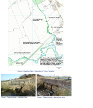
The Greatham Marsh Restoration project is centred on the restoration of intertidal habitat on the low-lying agricultural land near Greatham Village. Historically, the village was on the edge of the marshes but is now inland from the remaining intertidal areas.
The land is currently protected by flood banks constructed in the 18th century and a tidal structure with tidal flaps constructed in 1980 by the former water authority. The alignment of Greatham Beck was rationalised in approximately 1981 when the original meandering tributary was infilled.
The tidal structure was constructed under a licence that expires on 30 November 2029. A condition of the licence stipulates that on the expiry of the Licence, the structure is removed and riverbanks and foreshore reinstated.
This alone would not restore the full extent of natural processes and habitats. The oversized Greatham Beck would become a deep tidal creek and the floodplain would be inundated for long periods of time as a result of historic embankments and ineffective drainage.
So the Project intends to restore the former meandering channel of Greatham Beck and the network of tidal creeks within the floodplain. Areas of higher land within the field parcel are proposed to be managed as grasslands for conservation purposes. Habitats would be allowed to migrate inland as sea level rises.
The project contributes to achievement of WFD objectives by implementing targets for WFD protected sites found within the conservation objectives of the SPA, and mitigation measures for the Tees Estuary water body.
Monitoring surveys and results
- Water quality improvements
- Biodiversity River Units
- Biodiversity Area Units – including intertidal habitats and with unrestricted inland migration
- Nutrient reduction in Tees catchment subject to Nutrient Neutrality advice from NE
- Climate change through reduced operational carbon emissions and sequestration in habitat
- SPA SSSI improvement – unfavourable declining SSSI Unit die to excess nutrients, SPA objectives to reduce nutrients and restore extend intertidal habitats
Nature based solution through increased river channel capacity
Lessons learnt
Image gallery
|
Catchment and subcatchmentSelect a catchment/subcatchment
Catchment
Subcatchment
Other case studies in this subcatchment: Greatham Managed Realignment Scheme
Site
Project background
Cost for project phases
Supplementary funding informationpartnership funding
Supplementary InformationEdit Supplementary Information Construction start date – between September 2024 and January 2025 10 months construction phase Construction completion date – between July 2025 and November 2025 Dependent on permission and agreements Marine Licence application submitted January 2024 Planning Permission application submitted April 2024 Landowner Agreement Heads of Terms Partnership Contribution Agreement
Reasons for river restoration
Measures
MonitoringHydromorphological quality elements
Biological quality elements
Physico-chemical quality elements
Any other monitoring, e.g. social, economic
Monitoring documents
Additional documents and videos
Additional links and references
| ||||||||||||||||||||||||||||||||||||||||||||||||||||||||||||||||||||||||||||||||||||||||||||||||||||||||||||||||||||||||||||||||||||||||||||||||||||||||||||||||||||||||||||||||||||||||||||||||||||||||

