Case study:Chinbrook Meadows Wetlands: Difference between revisions
No edit summary |
No edit summary |
||
| Line 196: | Line 196: | ||
|Other motivation=Local amenity and community education | |Other motivation=Local amenity and community education | ||
}} | }} | ||
{{Measures}} | {{Measures | ||
|Bank and bed modifications measure=Partial diversion of river | |||
|Floodplain / River corridor=Wetland habitat, | |||
|Management interventions=Planting wildflower mixes, Riparian tree planting, plug planting | |||
|Social measures=Community Events, Community consultation, Community Events, Community Litter-picking work, Volunteer work parties using the local community., | |||
}} | |||
{{Hydromorphological quality elements header}} | {{Hydromorphological quality elements header}} | ||
{{End table}} | {{End table}} | ||
Revision as of 11:04, 19 July 2024
This case study is pending approval by a RiverWiki administrator.
Project overview
| Status | Complete |
|---|---|
| Project web site | http://https://www.thames21.org.uk/improving-rivers/chinbrook-community-suds-healthy-wetlands-challenge/ |
| Themes | Environmental flows and water resources, Flood risk management, Habitat and biodiversity, Monitoring, Social benefits, Water quality, Urban |
| Country | England |
| Main contact forename | Jo |
| Main contact surname | Goad |
| Main contact user ID | |
| Contact organisation | Thames21 |
| Contact organisation web site | http://www.thames21.org.uk/ |
| Partner organisations | Environment Agency, ERCIP / London Borough of Lewisham, Friends of Chinbrook Meadows, QWAG, Bonneville Environmental Foundation, Greater London Authority |
| Parent multi-site project | |
| This is a parent project encompassing the following projects |
No |
Project summary
The River Ravensbourne is a tributary of the River Thames, flowing for 17km from its spring in Keston, London Borough of Bromley, to its confluence with the Thames at Deptford. The area around the Ravensbourne is mainly urban and residential. However, it does flow through some greenspaces, including Chinbrook Meadows on the Bromley/ Lewisham boarder where the wetland is located.
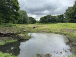
The site was previously a lightly used recreational field on the edge of a series of fields that make up Chinbrook Meadows. Anecdotally, the field was mainly used by dog walkers but was not as well used as other sections of the wider park. Grove Park Ditch runs from the northwest to the southeast, parallel to the south east railway line, where it joins the River Quaggy, a tributary of the River Ravensbourne. The ditch had become blocked and foul smelling, so the Friends of Chinbrook Meadows reported the problem to the London Borough of Lewisham, who manage the site. Alongside Thames21 a plan for a series of wetland scrapes was developed to treat the water from the ditch before it enters the River Quaggy.
The main outcome of the project is to improve water quality of the River Quaggy through increased removal of pollutants from surface water through the processes that will occur within the constructed wetland (sediment trapping, nutrient removal and chemical detoxification). Additionally, this project will involve the local community and learnings from this wetland project can be shared across the Ravensbourne Catchment Partnership. This will boost awareness of challenges to rivers and how nature-based solutions can tackle these. The aims of the project are fourfold:
1. Improve water quality of the River Quaggy and reduce foul smells on site
• The wetland uses wetland flora to naturally clean diverted water from the ditch before it enters the River Quaggy.
2. Improve biodiversity and amenity value of the land
• The wetland has replaced an area of grassland which had relatively low ecological value. Wetlands are well established self-sustaining ecosystems with high value flora and fauna.
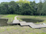
• Additionally, footpaths, wildflower meadows and interpretation boards will increase public access to the site and provide an opportunity to learn about aquatic habitats.
3. Natural flood management
• The wetland will provide additional storage of rainfall during high rainfall events and slow the flows of the River Quaggy.
4. Community Engagement
• Provide volunteering opportunities through activities such as water quality monitoring pre- and post-wetland creation, planting and vegetation management to engage the wider community in the long-term.
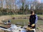
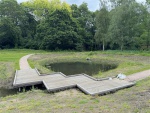
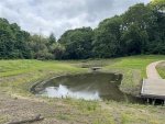
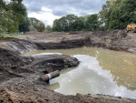
In the autumn 0f 2023, the wetlands were excavated. During the winter and spring of 23/24, a series of well-attended volunteering events were run to get the wetlands ready to be re-opened. The site was litter picked, hedgerows and dead hedges were installed and over 2,600 plug plants were planted in and around the ponds. In addition, a footpath and turf was laid to improve accessibility and a wildflower meadow was established on the earth mound. The park was re-opened to the public in the summer of 2024 with an ongoing maintenance and monitoring plan agreed with the landowners and managers in place for 2025 onwards.
Monitoring surveys and results
2016 Pre-intervention data:
Water Quality Sampling Summary (January - May 2016)
Sampling Locations:
1. Manhole at the top of Grove Park ditch
2. Inflow to Grove Park ditch proper
3. Outflow from Grove Park ditch into the Quaggy River
Results:
Nutrients:
1. Nitrate-nitrogen (NO3-N):
- Classified as good in all locations.
- Highest concentration: 5.25 mg/L (manhole).
2. Ammoniacal-nitrogen (NH3-N):
- Rated good at the manhole and ditch inflow, very good at the ditch outflow.
- Highest concentration after a long dry spell.
- Decreases from manhole to outflow due to nitrification cycle.
3. Total Nitrogen:
- Not monitored by WFD but poor according to European Nitrogen Assessment (ENA).
- Highest at the manhole (max: 14.2 mg/L, avg: 9.0 mg/L).
4. Phosphate (orthophosphate):
- Rated poor at the manhole, moderate in ditch locations.
- High variability in the manhole.
Heavy Metals:
1. Lead:
- Present in all samples, highest in the manhole (max: 0.4 mg/L).
2. Zinc:
- Below detection limits in ditch samples, present in manhole samples (avg: 0.3 mg/L).
3. Cadmium:
- Below detection limits in 50% of manhole samples, present at avg: 0.04 mg/L when detected.
4. Copper:
- Present in manhole samples, some ditch inflow, minimal ditch outflow. Max: 0.6 mg/L (manhole).
Other Parameters:
1. pH: Good in all sites.
2. Conductivity: No significant change between sites.
3. Coliform Bacteria: Improved from poor (manhole) to good (outflow).
4. BOD5 (Biochemical Oxygen Demand): Rated poor at all sites, slight improvement from manhole to outflow.
Post- intervention monitoring
ZSL Urban Wetland Monitoring Initiative
Chinbrook Meadows wetlands will host a trial citizen science project to monitor the health of the ponds. Developed by ZSL, the monitoring initiative will began in August 2024.
Lessons learnt
Community engagement
- Early and consistent community engagement is key
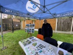
- Posters aren’t enough. Leaflets, presence at community events, word of mouth and meeting with councillors are all useful engagement techniques.
- Communicating nuance is difficult. Conversations around flood risk, biodiversity and water quality require care and patience. The importance of using language that is easily understood cannot be understated.
Logistics
- Construction site difficulties/ break ins. Securing the site was difficult with frequent break ins and vandalism.
- Deliveries to parks are difficult, especially here as a tunnel under the railway track restricts the vehicle size.
- Close relations with the council and contractors is key for support.
Image gallery
|
Catchment and subcatchment
Site
Project background
Cost for project phases
Reasons for river restoration
Measures
MonitoringHydromorphological quality elements
Biological quality elements
Physico-chemical quality elements
Any other monitoring, e.g. social, economic
Monitoring documents
Additional documents and videos
Additional links and references
Supplementary InformationEdit Supplementary Information
| ||||||||||||||||||||||||||||||||||||||||||||||||||||||||||||||||||||||||||||||||||||||||||||||||||||||||||||||||||||||||||||||||||||||||||||||||||||||||||||||||||||||||


