Case study:Glaisdale Beck Restoration Project: Difference between revisions
No edit summary |
No edit summary |
||
| Line 27: | Line 27: | ||
8. Small-scale bank stabilisation (materials for multiple sites): at 2+ sites | 8. Small-scale bank stabilisation (materials for multiple sites): at 2+ sites | ||
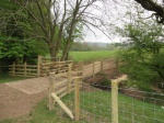
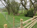
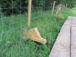
Improvement works were aimed at reducing the source of fine sediment, nutrients and bacterial loading primarily by addressing stretches of Glaisdale Beck (and associated ditch networks) where degraded habitat and large areas of poached bank sides were evident. Improvement works that were delivered included: erecting livestock fencing to prevent access to Glaisdale Beck (and associated ditches), creating buffer strips to filter surface runoff by promoting natural re-vegetation and reducing bank erosion, providing alternative livestock watering points, addressing poached crossing points and planting trees to help create a riparian woodland corridor. The Catchment Partnership Officer's role was to work closely with local land managers, draw up capital work agreements and deliver works. | Improvement works were aimed at reducing the source of fine sediment, nutrients and bacterial loading primarily by addressing stretches of Glaisdale Beck (and associated ditch networks) where degraded habitat and large areas of poached bank sides were evident. Improvement works that were delivered included: erecting livestock fencing to prevent access to Glaisdale Beck (and associated ditches), creating buffer strips to filter surface runoff by promoting natural re-vegetation and reducing bank erosion, providing alternative livestock watering points, addressing poached crossing points and planting trees to help create a riparian woodland corridor. The Catchment Partnership Officer's role was to work closely with local land managers, draw up capital work agreements and deliver works. This project is also a great example of working closely with the local Catchment Sensitive Farming (CSF) Officer to ensure the Glaisdale Beck Restoration Project worked alongside the new Countryside Stewardship Scheme. | ||
Glaisdale Beck Restoration Project was delivered by the Esk and Coastal Streams Catchment Partnership, a partnership between the Yorkshire Esk Rivers Trust and North York Moors National Park Authority. The project has delivered improvement works to reduce the impact of diffuse pollution that arises from rural land use and working towards preventing further deterioration of this waterbody - a vital step in working towards achieving good ecological status. | Glaisdale Beck Restoration Project was delivered by the Esk and Coastal Streams Catchment Partnership, a partnership between the Yorkshire Esk Rivers Trust and North York Moors National Park Authority. The project was funded thanks to the Catchment Partnership Action Fund and is a great example of partnership working with the Environment Agency. The project has delivered improvement works to reduce the impact of diffuse pollution that arises from rural land use and working towards preventing further deterioration of this waterbody - a vital step in working towards achieving good ecological status. | ||
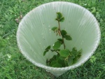
The Esk and Coastal Stream Catchment Partnership engaged with nine key land managers in the dale, providing one-to-one Water Friendly Farming advice. 2927m of riparian fencing has been installed along Glaisdale Beck, key tributaries and associated ditched networks to reduce sediment and phosphate pathways. Over 1.5ha of buffer strips have been created to promote natural regeneration of trees and allow vegetation such as Greater woodrush to establish in these un-grazed strips. Two cattle pasture pumps and six livestock draining bays have been installed, and 65 trees have been planted in the new buffer strips to increase the tree age structure in the dale. 20m of bank stabilisation work has also been undertaken. | The Esk and Coastal Stream Catchment Partnership engaged with nine key land managers in the dale, providing one-to-one Water Friendly Farming advice. 2927m of riparian fencing has been installed along Glaisdale Beck, key tributaries and associated ditched networks to reduce sediment and phosphate pathways. Over 1.5ha of buffer strips have been created to promote natural regeneration of trees and allow vegetation such as Greater woodrush to establish in these un-grazed strips. Two cattle pasture pumps and six livestock draining bays have been installed, and 65 trees have been planted in the new buffer strips to increase the tree age structure in the dale. 20m of bank stabilisation work has also been undertaken. | ||
Revision as of 16:37, 12 January 2017
Project overview
| Status | Complete |
|---|---|
| Project web site | |
| Themes | Habitat and biodiversity, Land use management - agriculture, Monitoring, Water quality |
| Country | England |
| Main contact forename | Alex |
| Main contact surname | Cripps |
| Main contact user ID | |
| Contact organisation | Yorkshire Esk Rivers Trust |
| Contact organisation web site | http://www.yorkshireeskriverstrust.org/ |
| Partner organisations | North York Moors National Park Authority |
| Parent multi-site project | |
| This is a parent project encompassing the following projects |
No |
Project summary
Glaisdale Beck faces many pressures, predominantly fine sedimentation, nutrient and organic matter enrichment. Before the Glaisdale Beck Restoration Project works were delivered, the waterbody status was downgraded to moderate status, as it is failing for phosphate (2015 Cycle 2). This project was an essential step in working towards achieving good ecological status by 2021.
The main objectives for the 2015/16 Glaisdale Beck Restoration Project were:
1. Engage with key farms: between 7-10 farms
2. One-to-one farm advice (Water Friendly Farming): at 7-10 farms
3. Erect riverside fencing and create buffer strips: ~2km of riparian fencing and associated buffer strips
4. Install infrastructure improvements: such as watering points and tracks
5. Tree planting: 200+ trees
6. Large woody debris (materials for multiple sites): at 2+ sites
7. Coppicing (two man days with tractor): at 2 sites
8. Small-scale bank stabilisation (materials for multiple sites): at 2+ sites
Improvement works were aimed at reducing the source of fine sediment, nutrients and bacterial loading primarily by addressing stretches of Glaisdale Beck (and associated ditch networks) where degraded habitat and large areas of poached bank sides were evident. Improvement works that were delivered included: erecting livestock fencing to prevent access to Glaisdale Beck (and associated ditches), creating buffer strips to filter surface runoff by promoting natural re-vegetation and reducing bank erosion, providing alternative livestock watering points, addressing poached crossing points and planting trees to help create a riparian woodland corridor. The Catchment Partnership Officer's role was to work closely with local land managers, draw up capital work agreements and deliver works. This project is also a great example of working closely with the local Catchment Sensitive Farming (CSF) Officer to ensure the Glaisdale Beck Restoration Project worked alongside the new Countryside Stewardship Scheme.
Glaisdale Beck Restoration Project was delivered by the Esk and Coastal Streams Catchment Partnership, a partnership between the Yorkshire Esk Rivers Trust and North York Moors National Park Authority. The project was funded thanks to the Catchment Partnership Action Fund and is a great example of partnership working with the Environment Agency. The project has delivered improvement works to reduce the impact of diffuse pollution that arises from rural land use and working towards preventing further deterioration of this waterbody - a vital step in working towards achieving good ecological status.
The Esk and Coastal Stream Catchment Partnership engaged with nine key land managers in the dale, providing one-to-one Water Friendly Farming advice. 2927m of riparian fencing has been installed along Glaisdale Beck, key tributaries and associated ditched networks to reduce sediment and phosphate pathways. Over 1.5ha of buffer strips have been created to promote natural regeneration of trees and allow vegetation such as Greater woodrush to establish in these un-grazed strips. Two cattle pasture pumps and six livestock draining bays have been installed, and 65 trees have been planted in the new buffer strips to increase the tree age structure in the dale. 20m of bank stabilisation work has also been undertaken.
Additional benefits as a result of this project include - 1. The Esk is a Drinking Water Protected Area, works delivered will improve raw water quality which will help reduce water treatment costs, 2) Overall biodiversity will improve - robust and connected habitats supporting a diverse range of species will provide more resilience to other pressures such as global climate change, 3) Fish populations will benefit from the improved spawning habitat, with a knock on benefit to the endangered freshwater pearl mussel, 4) Reducing bacterial loading from livestock will benefit the bathing water quality downstream, 5) Recreation and associated economic costs will benefit; wildlife watching, angling, freshwater activities such as boating, bathing water/coastal recreation, 6) Improving farm infrastructure will have knock on benefits for farm productivity/and farm business gains, 7) Water Friendly Farming leaflet circulation and one-to-one farm advice will improve local rural education on best practice, 8) Engaging with key farmers and building up good relationships, along with the opportunity to complete detailed surveys of the catchment enabled the Partnership to built up a picture of further priority works which need to be delivered to work towards achieving good ecological status by 2021, 9) Lessons learnt from this project will benefit the wider Esk and Coastal Streams catchment and help shape future restoration projects/habitat improvement works.
Monitoring surveys and results
Recording the length of riparian habitat not accessed by stock - on farm surveys and mapping were undertaken to create a baseline of the area prior to improvement works being delivered. An additional layer of final improvement works has subsequently been mapped.
Monitoring the increase of ground cover and abundance and diversity of plant and tree species in newly created buffer strips - fixed point photographs were taken before improvement works were delivered, and photographs were taken again very shortly after works were been completed. As we expect an ecological lag time to detect the benefits of the improvement works delivered, these fixed point photographs will be repeated again at key sites in three years time to assess long term change.
Monitoring newly planted trees and ensuring tree stakes and guards are upright and secure - newly planted trees will be monitored over the next five years by each farmer, who will report to the Catchment Partnership Officer if any have died (so that they can be replaced), or if any work is needed such as re-staking after high flow conditions.
Monitoring bank stabilisation: this work will be monitored using fixed-point photographs.
Monitoring water quality, before and after restoration works, and highlighting any pollution incidents - we have baseline data of macro-invertebrate monitoring to family level identification and resulting BMWP scores using standard three minute kick samples at eight sites. These samples were collected in Autumn 2014 and Spring 2015. We undertook some volunteer lead Riverfly Monitoring surveys before restoration works were delivered at two sites on Glaisdale Beck. Following the restoration works Riverfly Monitoring is being undertaken at these two sites each month from May - October 2016 and for future years as we expect an ecological lag time (around three years for invertebrates). Our Riverfly Monitoring volunteers are now also recording phosphate and nitrate levels. We also hope to develop a new monitoring site in Glaisdale Beck to assess phosphate levels.
Following the commencement of the works (May 2016), an ecological lag time is expected before benefits to water quality and the riparian habitat will be evident. Our monitoring planner will enable us to record these benefits in due course.
Lessons learnt
Short time-scales of the project resulted in time pressures in surveying the catchment, prioritising key restoration works, and implementing these plans to ensure works were delivered on the ground within the year. We also had difficulty in securing local contractors to deliver works with the short notice, but we did secure contractors who did a great job. The Partnership has now built up a very useful local contractors list for future river restoration projects.
Uncontrollable factors such as the very wet weather experienced through autumn, winter 2015 and most of spring 2016 were out of our control, but by agreeing with our project funders we were able to extend the project by two months to complete all works.
As the Glaisdale Beck Restoration Project focused on a small area of the Esk and Coastal Streams Catchment it has enabled us to build very good relations with the local land managers/owners. There are still further works to be done to continue to improve the Glaisdale Beck waterbody and riparian habitat, but this project has opened doors for us to deliver further works in the future.
Image gallery
|
Catchment and subcatchment
Site
Project background
Cost for project phases
Reasons for river restoration
Measures
MonitoringHydromorphological quality elements
Biological quality elements
Physico-chemical quality elements
Any other monitoring, e.g. social, economic
Monitoring documents
Additional documents and videos
Additional links and references
Supplementary InformationEdit Supplementary Information
| ||||||||||||||||||||||||||||||||||||||||||||||||||||||||||||||||||||||||||||||||||||||||||||||||||||||||||||||||||||||||||||||||||||||||||||||||||||||||||||||||||||||||||||||||||


