Case study:Haltwhistle burn; a total catchment approach: Difference between revisions
Hazel Wilson (talk | contribs) No edit summary |
Hazel Wilson (talk | contribs) No edit summary |
||
| Line 107: | Line 107: | ||
{{Site | {{Site | ||
|Name=Haltwhistle | |Name=Haltwhistle | ||
|WFD water body code= | |WFD water body code=GB103023075570 | ||
|WFD water body name=Haltwhistle | |WFD water body name=Haltwhistle Burn from Source to South Tyne | ||
|Heavily modified water body=No | |Heavily modified water body=No | ||
|Site designation=All - multiple designations across the site | |Site designation=All - multiple designations across the site | ||
| Line 114: | Line 114: | ||
|Protected species present=Yes | |Protected species present=Yes | ||
|Invasive species present=Yes | |Invasive species present=Yes | ||
|Species=white-clawed crayfish (Austropotamobius pallipes), | |Species=white-clawed crayfish (Austropotamobius pallipes), | ||
}} | }} | ||
{{Project background | {{Project background | ||
Revision as of 11:57, 20 November 2015
Project overview
| Status | In progress |
|---|---|
| Project web site | |
| Themes | Flood risk management, Habitat and biodiversity, Hydromorphology, Land use management - agriculture, Land use management - forestry, Monitoring, Water quality |
| Country | England |
| Main contact forename | Ceri |
| Main contact surname | Gibson |
| Main contact user ID | User:Halty |
| Contact organisation | Tyne Rivers Trust |
| Contact organisation web site | http://tyneriverstrust.org/ |
| Partner organisations | Haltwhistle Town Council, Northumberland National Park, Northumberland County Council, Forestry Commission, Natural England, Environment Agency, Newcastle University (NiRES), Hadrian’s Wall Heritage Ltd |
| Parent multi-site project | |
| This is a parent project encompassing the following projects |
No |
Project summary
Haltwhistle Burn: ‘a total catchment’ approach is a partnership project which will use CRF funds to improve the whole catchment which has suffered the pressures of quarrying, farming, industry and an increasing population. Although the ‘official’ reasons for failure concern pressures on fish according to the criteria provided by the Water Framework Directive (WFD) this project addresses total waterbody issues deriving from a multitude of pressures, each creating ‘sub-lethal’ but chronic stresses.
Haltwhistle’s ‘Centre of Britain’ identity, together with attraction of Hadrian’s Wall makes it a po-tentially significant tourism centre, with a focus on both heritage and natural features. There are however significant economic difficulties and youth behaviour issues. Haltwhistle Burn is a central focus and has already attracted works of improvement and interpretation by the Haltwhis-tle Partnership.
Since the 2007 floods in the town, Tyne Rivers Trust has nurtured excellent relationships with agencies and extremely enthusiastic individuals directly connected to their catchment. Whilst the project is not a flood defence project this CRF funding now gives us a clear focus for agency action and direct spending on mitigating excess runoff and pollution.
Tyne Rivers Trust have already carried out geomorphological and habitat assessment of the entire burn, concluding that the ‘catchment approach’ would, by combining the small issues, create a significant benefit for the South Tyne and address the WFD ‘poor status’ classification.
Monitoring surveys and results
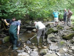
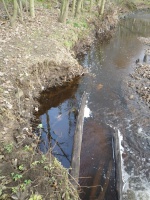
This project is still in progress. To date we have restored 45m of channel and 200m of river bank. We have planted 190 trees. We have set up photographic fixed point monitoring sites for the river bank management work and after one season of regrowth the work is doing what we had hoped. We have 3 Riverfly monitors sampling on the burn and to date none of our intervention has had a negative effect. We have completed the preliminary electro-fishing surveys; the next permissible electro-fishing sweason is from July 2014. Another element of this project is also working with the local community to gather information on rainfall, river level, water temperature, turbidity, other chemical water quality measurements and fixed-point photography.
Lessons learnt
It is impossible to achievement multiple benefits in a hollistic approach project without the support and commitment of partners, local land owners and local residents. We have only managed to achieve this through dedicating time to bringing the right people together and explaining clearly our aims and overlapping benefits. Only then can efective work on the ground begin. It is vital to consider legacy and exit-strategy right from the beginning. Working at the sub-catchment scale cannot be considered in the short-term. Management and maintenance of interventions must be planned for and bought into within the community.
Image gallery
|
Catchment and subcatchmentSelect a catchment/subcatchment
Catchment
Subcatchment
Site
Project background
Cost for project phases
Reasons for river restoration
Measures
MonitoringHydromorphological quality elements
Biological quality elements
Physico-chemical quality elements
Any other monitoring, e.g. social, economic
Monitoring documents
Additional documents and videos
Additional links and references
Supplementary InformationEdit Supplementary Information
| ||||||||||||||||||||||||||||||||||||||||||||||||||||||||||||||||||||||||||||||||||||||||||||||||||||||||||||||||||||||||||||||||||||||||||||||||||||||||||||||||||||||||||||||||||||||||||||||||||||||||||


