Case study:Great Ryburgh End Restoration Scheme: Difference between revisions
No edit summary |
No edit summary |
||
| Line 38: | Line 38: | ||
|Subcatchment=Wensum US Norwich | |Subcatchment=Wensum US Norwich | ||
}} | }} | ||
{{Site}} | {{Site | ||
|WFD water body code=GB105034055881 | |||
|Heavily modified water body=No | |||
|Protected species present=No | |||
|Invasive species present=No | |||
}} | |||
{{Project background | {{Project background | ||
|Reach length directly affected=1320 | |Reach length directly affected=1320 | ||
Revision as of 11:06, 1 September 2015
Project overview
| Status | Complete |
|---|---|
| Project web site | |
| Themes | Fisheries, Habitat and biodiversity, Hydromorphology |
| Country | England |
| Main contact forename | Adam |
| Main contact surname | Thurtle |
| Main contact user ID | User:Rdryden |
| Contact organisation | Environment Agency |
| Contact organisation web site | http://www.environment-agency.gov.uk |
| Partner organisations | Natural England, Water Management Alliance |
| Parent multi-site project | |
| This is a parent project encompassing the following projects |
No |
Project summary
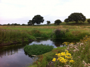
The restored reach at Great Ryburgh extends between Great Ryburgh Mill and Sennowe Bridge. A significant length of meandering river channel was completely bypassed by a straightened channel sometime in the mid nineteenth century. The engineered channel was over deep, isolated from the floodplain and lacked both flow and habitat diversity. A feasibility study indicated that the reconnection of 1100m of the original course would significantly improve the ecology and natural functioning of the SSSI and SAC.
A key part of the restoration was to reinstate the original course by plugging the straightened channel and creating a new link to the original course at the upstream end. The height of the plug was set so that it can be overtopped during high flows and functions as an overflow channel. The new link channel was designed to restore some of the geomorphological function lost when the channel was straightened. The downstream end of the straightened channel has been left open to create an ecologically valuable backwater. Although disconnected, the line of the original channel remained and mature alder and willow were evident in places along the margins. The old channel was excavated to match natural geomorphological features as much as possible. Where riverbed gravels were found they were left intact, and supplemented in some areas to create shallow glides.
Deeper pools were dug on the outer bends of meanders and lateral berms and woody debris were installed to increase sinuosity. Backwaters and bays have also been created along the channel to provide fish refuge and additional habitat. Native shrubs and trees, predominantly willow and alder, have been selectively planted to create riparian shade and these have been fenced to protect them from grazing livestock.
Monitoring surveys and results
2013's post-restoration electro-fishing survey recorded 705 fish representing 12 species, an increase from the 107 fish of 7 species caught in 2012 when the habitat was still quite bare following restoration. These figures compare with 158 fish of 9 caught in a pre-restoration survey in an immediately adjacent reach. Fish density in the restoration site in 2013 was 11.7 individuals per 100m² compared with 5.7 per 100m² in the pre-restoration survey site. Standing crop was 568 grams per 100m² in the restoration site, a small increase on the 508 grams per 100m² recorded during the pre-restoration survey. Numbers of stone loach, bullhead, brook lamprey, brown trout, dace and gudgeon have increased compared with the pre-restoration conditions. Further monitoring will be undertaken in future years to understand more about how fish populations change in response to habitat improvements.
The low level shelves created at summer water level at the channel margins have been colonised by a diverse flora including water mint, water forget-me-not, brooklime and gipsywort. The river channel itself supports a number of typical chalk stream plant species including watercress, water starwort, lesser water-parsnip and whorl-grass.
Lessons learnt
The in-channel works have been successful and flow diversity and sinuosity has been achieved. The lateral berms and woody debris have vegetated quickly, providing physical habitat and creating additional flow diversity. Marginal vegetation is well established and the banks support an extremely diverse range of species. The planted trees are growing well and several self-seeded trees, predominantly alder, are establishing along the banks.
The new backwaters hold an abundance of fish fry, and trout were observed resting in the pools. In addition, a kingfisher and otter spraint and prints were sighted during the RRC visit. Ecological surveys were carried out in August 2013 and the results of these will determine the extent of ecological recovery following the works. Some adaptive management of the upstream end of the plug has been undertaken. Locally sourced turfs have been used to reinforce the plug and reduce erosion during high flows. Some cattle poaching has occurred at the upstream end of the reinstated channel, and although action is not currently necessary, this will continue to be monitored by the Environment Agency.
Image gallery
|
Catchment and subcatchmentSelect a catchment/subcatchment
Catchment
Subcatchment
Other case studies in this subcatchment: Meander reinstatement on the River Wensum at the Ryburgh Loop, River Wensum Restoration, Reach 10 Lenwade, River Wensum Restoration, Reach 3a Costessey, River Wensum Restoration, Reach 9 Attlebridge, River rehabilitation on the River Wensum at Swanton Morley, Sculthorpe Moor Restoration Scheme, Wensum River Restoration and Floodplain Enhancement, Wensum River Restoration and Floodplain Enhancement, Pensthorpe
Site
Project background
Cost for project phases
Reasons for river restoration
Measures
MonitoringHydromorphological quality elements
Biological quality elements
Physico-chemical quality elements
Any other monitoring, e.g. social, economic
Monitoring documents
Additional documents and videos
Additional links and references
Supplementary InformationEdit Supplementary Information
| ||||||||||||||||||||||||||||||||||||||||||||||||||||||||||||||||||||||||||||||||||||||||||||||||||||||||||||||||||||||||||||||||||||||||||||||||||||||||||||||||||||||||||||||||||||||||||||||||||||||||||||


