Case study:Houghton 'trout stream' enhancements: Difference between revisions
Robclapham (talk | contribs) No edit summary |
Robclapham (talk | contribs) No edit summary |
||
| Line 54: | Line 54: | ||
|File name=Chub by deflector 2.jpg | |File name=Chub by deflector 2.jpg | ||
|Caption=Chub preparing to spawn around 'v' deflector | |Caption=Chub preparing to spawn around 'v' deflector | ||
}} | |||
{{Case study image | |||
|File name=Finished deflector 2.jpg | |||
|Caption=Finished deflector in May 2014 | |||
}} | }} | ||
{{Image gallery end}} | {{Image gallery end}} | ||
Revision as of 14:26, 14 May 2014
Project overview
| Status | Complete |
|---|---|
| Project web site | |
| Themes | Fisheries, Hydromorphology |
| Country | England |
| Main contact forename | Rob |
| Main contact surname | Clapham |
| Main contact user ID | |
| Contact organisation | Environment Agency |
| Contact organisation web site | http://www.gov.uk/government/organisations/environment-agency |
| Partner organisations | |
| Parent multi-site project | |
| This is a parent project encompassing the following projects |
No |
Project summary
The Houghton ’trout’ stream is an important side channel of the Great Ouse providing many habitat types that are not present in the navigable main channel.
Over the last decade there has been a decline in the number of fish species present in the stream. This is likely a result of historic over-widening, catchment sediment issues and flow regulation which have changed or degraded the habitat.
The Environment Agency worked with the local fishing club and landowners to improve the status of the stream putting in place a number of measures to address pressures and improve habitat.
These measures include:
- Gravel Cleaning has been carried out to improve spawning gravels. Limited flows in an over-wide channel have resulted in a lot of fine sediment to drop out of suspension and smother the gravels. High powered jets of water are used to remove silt between gravels and improve the chances of successful fish spawning.
- Tree Planting has been started in various locations. Trees will provide shelter and shade for various fish species as well as habitat for macroinvertebrates. In future years they will provide woody material to the channel which will help create in-channel habitat. They are also important for moderating river water temperatures.
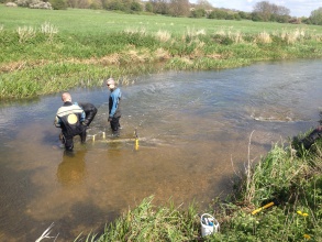
- Wooden flow deflectors have been installed in a number of locations on the stream. These increase flow velocities over the spawning gravel preventing build up of fine sediment in slow flows. These should be self sustaining and reduce the need to gravel clean by hand each year.
- Flow improvement works have been carried out at the weir. Overhanging and submerged trees, and vegetation has been removed to improve flows and prevent further build up of materials and sediment.
- Fencing will be installed in summer 2014 to protect trees from cattle and prevent in-channel access close to enhanced spawning riffles
Monitoring surveys and results
Pre-enhancement fish surveys have been undertaken
Post-enhancement fish surveys will be carried out in subsequent years
Lessons learnt
Wood for construction of deflectors was sourced locally and work was undertaken by hand. Therefore the size of deflectors were limited to what could be manoeuvred by hand. Despite their size, careful consideration of the prevailing flow and sediment conditions meant they could be placed to achieve optimum benefit.
Image gallery
|
Catchment and subcatchmentSelect a catchment/subcatchment
Catchment
Subcatchment
Other case studies in this subcatchment: Houghton 'trout stream' enhancements
Site
Project background
Cost for project phases
Reasons for river restoration
Measures
MonitoringHydromorphological quality elements
Biological quality elements
Physico-chemical quality elements
Any other monitoring, e.g. social, economic
Monitoring documents
Additional documents and videos
Additional links and references
Supplementary InformationEdit Supplementary Information
| |||||||||||||||||||||||||||||||||||||||||||||||||||||||||||||||||||||||||||||||||||||||||||||||||||||||||||||||||||||||||||||||||||||||||||||||||||||||||||||||||||||||||||||||||||||||||||||||||||||||||||||||


