Case study:Quaggy channel improvements: Difference between revisions
No edit summary |
Mattleeson (talk | contribs) No edit summary |
||
| Line 25: | Line 25: | ||
The riverbed has also been altered to create a more natural river with meanders and areas of deep and shallow water. Faster and slower flowing areas improve habitat for wildlife. Specialist bird boxes have been built into brick walls to provide nesting sites for grey wagtail and wrens. | The riverbed has also been altered to create a more natural river with meanders and areas of deep and shallow water. Faster and slower flowing areas improve habitat for wildlife. Specialist bird boxes have been built into brick walls to provide nesting sites for grey wagtail and wrens. | ||
}} | }} | ||
{{Case study subcatchment}} | {{Case study subcatchment | ||
|Subcatchment=River Quaggy | |||
}} | |||
{{Site | {{Site | ||
|Name=Weigall Road to Lewisham | |Name=Weigall Road to Lewisham | ||
Revision as of 16:13, 29 August 2012
This case study is pending approval by a RiverWiki administrator.
Project overview
| Status | Complete |
|---|---|
| Project web site | |
| Themes | Flood risk management |
| Country | England |
| Main contact forename | Toni |
| Main contact surname | Scarr |
| Main contact user ID | User:Ascarr |
| Contact organisation | Environment Agency |
| Contact organisation web site | http://www.environment-agency.gov.uk |
| Partner organisations | Quaggy Waterways Action Group |
| Parent multi-site project | |
| This is a parent project encompassing the following projects |
No |
Project summary
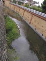
Along the stretch of river between Weigall Road and the centre of Lewisham, the Quaggy runs through rear gardens, beneath roads and along open urban spaces.
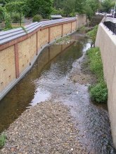
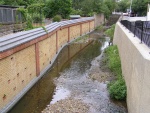
Some of the houses close to the river, mostly terraced homes, were at high risk of flooding. Our innovative approach allowed us to integrate flood defences sensitively within people’s gardens. These are now set back from the river, recovering land that can be used as part of the flood plain.
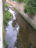
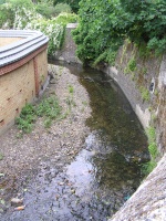
The riverbed has also been altered to create a more natural river with meanders and areas of deep and shallow water. Faster and slower flowing areas improve habitat for wildlife. Specialist bird boxes have been built into brick walls to provide nesting sites for grey wagtail and wrens.
Monitoring surveys and results
Lessons learnt
Catchment and subcatchment
Edit the catchment and subcatchment details
(affects all case studies in this subcatchment)
Site
| Name | Weigall Road to Lewisham |
|---|---|
| WFD water body codes | GB106039023290 |
| WFD (national) typology | Calcareous |
| WFD water body name | Quaggy |
| Pre-project morphology | |
| Reference morphology | |
| Desired post project morphology | |
| Heavily modified water body | Yes |
| National/international site designation | |
| Local/regional site designations | |
| Protected species present | No |
| Invasive species present | Yes |
| Species of interest | Japanese Knotweed |
| Dominant hydrology | |
| Dominant substrate | |
| River corridor land use | Urban |
| Average bankfull channel width category | |
| Average bankfull channel width (m) | |
| Average bankfull channel depth category | |
| Average bankfull channel depth (m) | |
| Mean discharge category | |
| Mean annual discharge (m3/s) | |
| Average channel gradient category | |
| Average channel gradient | |
| Average unit stream power (W/m2) |
Project background
| Reach length directly affected (m) | |
|---|---|
| Project started | |
| Works started | |
| Works completed | |
| Project completed | |
| Total cost category | |
| Total cost (k€) | |
| Benefit to cost ratio | |
| Funding sources |
Cost for project phases
| Phase | cost category | cost exact (k€) | Lead organisation | Contact forename | Contact surname |
|---|---|---|---|---|---|
| Investigation and design | |||||
| Stakeholder engagement and communication | |||||
| Works and works supervision | |||||
| Post-project management and maintenance | |||||
| Monitoring |
Reasons for river restoration
| Mitigation of a pressure | |
|---|---|
| Hydromorphology | |
| Biology | |
| Physico-chemical | |
| Other reasons for the project |
Measures
Structural measures
| |
|---|---|
| Bank/bed modifications | |
| Floodplain / River corridor | |
| Planform / Channel pattern | |
| Other | |
Non-structural measures
| |
| Management interventions | |
| Social measures (incl. engagement) | |
| Other | |
Monitoring
Hydromorphological quality elements
| Element | When monitored | Type of monitoring | Control site used | Result | ||
|---|---|---|---|---|---|---|
| Before measures | After measures | Qualitative | Quantitative | |||
Biological quality elements
| Element | When monitored | Type of monitoring | Control site used | Result | ||
|---|---|---|---|---|---|---|
| Before measures | After measures | Qualitative | Quantitative | |||
Physico-chemical quality elements
| Element | When monitored | Type of monitoring | Control site used | Result | ||
|---|---|---|---|---|---|---|
| Before measures | After measures | Qualitative | Quantitative | |||
Any other monitoring, e.g. social, economic
| Element | When monitored | Type of monitoring | Control site used | Result | ||
|---|---|---|---|---|---|---|
| Before measures | After measures | Qualitative | Quantitative | |||
Monitoring documents
Image gallery
Additional documents and videos
Additional links and references
| Link | Description |
|---|
Supplementary Information
Edit Supplementary Information

