Case study:River Skerne- Life project: Difference between revisions
No edit summary |
No edit summary |
||
| Line 18: | Line 18: | ||
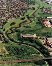
|Project picture=Cropped aerial Skerne.jpg | |Project picture=Cropped aerial Skerne.jpg | ||
|Picture description=Aerial view of the completed Skerne works | |Picture description=Aerial view of the completed Skerne works | ||
|Project summary=Background: The River Skerne is a tributary of the River Tees in North East England. The | |Project summary=Background: The River Skerne is a tributary of the River Tees in North East England. The restored reach lies in a sub-urban area on the outskirts of Darlington, County Durham. During the last 150 years, the River Skerne has been heavily modified as a result of industrialisation and urbanisation. Between 1850 and 1945 the river was straightened and channelized, and the river corridor was markedly narrowed. Widening and deepening was undertaken in the 1950s and the 1970s, and new housing developments were built along the entire north side of the river. The area has a rich industrial heritage including the first railway company Stockton and Darlington. The Skerne (railway) Bridge, which can be found just downstream of the site, was pictured on the old five pound notes. | ||
Restoration: The River Skerne was included in a joint initiative between England and Denmark to demonstrate best practice in urban and rural river rehabilitation and encourage river restoration in Europe. The wider aim was to promote further river restoration and demonstrate how river restoration could provide multiple benefits such as enhancement in wildlife, landscape, recreation, water quality, fisheries, amenities and other local interests. | Restoration: The River Skerne was included in a joint initiative between England and Denmark to demonstrate best practice in urban and rural river rehabilitation and encourage river restoration in Europe. The wider aim was to promote further river restoration and demonstrate how river restoration could provide multiple benefits such as enhancement in wildlife, landscape, recreation, water quality, fisheries, amenities and other local interests. | ||
Revision as of 10:51, 21 February 2014
Project overview
| Status | Complete |
|---|---|
| Project web site | |
| Themes | Economic aspects, Habitat and biodiversity, Social benefits, Water quality, Urban |
| Country | England |
| Main contact forename | RRC |
| Main contact surname | River Restoration Centre |
| Main contact user ID | User:NickRRC |
| Contact organisation | Life Project |
| Contact organisation web site | http://www.therrc.co.uk |
| Partner organisations | River Restoration Centre, Darlington Borough Council, Environment Agency, Natural England |
| Parent multi-site project | |
| This is a parent project encompassing the following projects |
No |
Project summary
Background: The River Skerne is a tributary of the River Tees in North East England. The restored reach lies in a sub-urban area on the outskirts of Darlington, County Durham. During the last 150 years, the River Skerne has been heavily modified as a result of industrialisation and urbanisation. Between 1850 and 1945 the river was straightened and channelized, and the river corridor was markedly narrowed. Widening and deepening was undertaken in the 1950s and the 1970s, and new housing developments were built along the entire north side of the river. The area has a rich industrial heritage including the first railway company Stockton and Darlington. The Skerne (railway) Bridge, which can be found just downstream of the site, was pictured on the old five pound notes.
Restoration: The River Skerne was included in a joint initiative between England and Denmark to demonstrate best practice in urban and rural river rehabilitation and encourage river restoration in Europe. The wider aim was to promote further river restoration and demonstrate how river restoration could provide multiple benefits such as enhancement in wildlife, landscape, recreation, water quality, fisheries, amenities and other local interests.
The restoration of 2 km of the Skerne was initiated in July 1995. Much of the floodplain had been raised by old industrial waste tipping, with gas and sewer pipes running alongside the river. As a result of these constraints, restoration opportunities were severely limited - typical of urban rivers elsewhere. At the upstream end, instream deflectors and a coarse sediment riffle were installed to enhance flow variability and habitat diversity. Further downstream four new meanders were cut across the old channel, which was used to create two backwaters. Soft revetments – such as willow mattress, willow spiling, underwater rock layer, fibre rolls, and geotextiles – were used on the outer meander bends to prevent erosion towards the gas main. As a flood water retention measure, about 25,000 m3 of spoil was removed from the river banks. This also aimed to increase the lateral connectivity between the river and the adjacent floodplain. The spoil was later used for landscaping purposes.
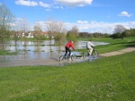
Thirteen ugly surface water outfalls were replaced with underground inspection /collection chambers that firstly intercept pollution and then discharge the water into the river below water level. New footpaths were constructed and a planting scheme engaging local residents carried out. At the downstream end of the restored section a new footbridge was constructed, designed to resemble a locomotive as a tribute to the historical significance of the Skerne Bridge.
Monitoring surveys and results
Lessons learnt
Image gallery
|
Catchment and subcatchmentSelect a catchment/subcatchment
Catchment
Subcatchment
Site
Project background
Cost for project phases
Reasons for river restoration
Measures
MonitoringHydromorphological quality elements
Biological quality elements
Physico-chemical quality elements
Any other monitoring, e.g. social, economic
Monitoring documents
Additional documents and videos
Additional links and references
Supplementary InformationEdit Supplementary Information
| ||||||||||||||||||||||||||||||||||||||||||||||||||||||||||||||||||||||||||||||||||||||||||||||||||||||||||||||||||||||||||||||||||||||||||||||||||||||||||||||||||||||||||||||||||||||||||||||||||||||||||||||||||||||||||||||||


