Case study:Abbotts Hall Managed Realignment Scheme: Difference between revisions
No edit summary |
No edit summary |
||
| Line 49: | Line 49: | ||
|River corridor land use=Arable | |River corridor land use=Arable | ||
}} | }} | ||
{{Project background}} | {{Project background | ||
|Funding sources=WWF and the Heritage Lottery Fund | |||
}} | |||
{{Motivations}} | {{Motivations}} | ||
{{Measures}} | {{Measures}} | ||
Revision as of 08:59, 27 September 2013
This case study is pending approval by a RiverWiki administrator.
Project overview
| Status | Complete |
|---|---|
| Project web site | |
| Themes | Flood risk management, Habitat and biodiversity |
| Country | England |
| Main contact forename | Dave |
| Main contact surname | Smart |
| Main contact user ID | |
| Contact organisation | Essex Wildlife Trust |
| Contact organisation web site | http://http://www.essexwt.org.uk/visitor centres nature reserves/abbotts hall farm/ |
| Partner organisations | English Nature, Environment Agency |
| Parent multi-site project | |
| This is a parent project encompassing the following projects |
No |
Project summary
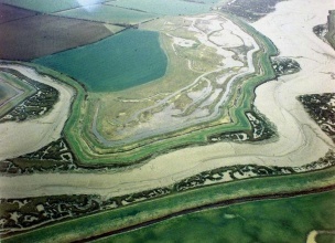
The location of the project is in the North bank of the Salcott channel tributary of the Blackwater Estuary (Essex). The strategy was creation of new coastal (mudflat, saltmarsh, transitional grassland and grazing marsh) and freshwater habitats, together with the provision of natural flood defence. In order to achieve tidal inundation of the area available (49ha of the 85ha scheme are intertidal), five breaches were required along 3km of hard defences. The largest breach was 100m in width with a level of +1.5m OD (approximately MHWN), and the remaining four breaches between 10-20m (at higher levels). The main breach was included to moderate outflow by acting as a sill, reducing the tidal prism of the site, and controlling the phasing of exchange between Salcott Creek and the site itself.
Phase 1 of the scheme was undertaken in 1996 and consisted of a regulated tidal exchange on part of the site (20ha). Pre-breach, a three year monitoring programme was undertaken to ensure appropriate scheme design for the site and to provide a baseline for determining its effects. Following realignment, a further five year monitoring programme was established to assess the effects and provide further information for the design of future schemes. Monitoring undertaken:
Accretion / erosion.
Monitoring surveys and results
The following aspects were monitored for at least two years (vegetation and birds longer): accretion / erosion on site (altimetry); accretion/erosion off site; scour (in breach B); bathymetry (one off); tidal levels and velocities; suspended solids off site; salinity off site; invertebrates off site (one off); vegetation; birds; fish; amphibians/reptiles
Lessons learnt
According to the Essex Wildlife Trust (2005), the scheme has been effective in safeguarding the local natural environment of the Salcott Channel and the West Mersea Oyster Fishery downstream of the realignment site. The additional monitoring works undertaken at the request of the local oystermen have demonstrated no noticeable effects on their activities.
The natural slope of the site has benefited small fry which have been observed rising through the vegetation with the tide. The gradual slope allows for the zonation of vegetation and provides a mosaic of habitats for a range of sizes and species of fish. The semi permanent pools, which are inundated on high tides, serve as feeding and refuge areas over a tidal cycle. On one occasion, 2000 herring/sprat were caught using a seine net in one tidal pool. This illustrates the value of the realignment site as being beneficial for both commercial and recreational fisheries in the Blackwater estuary.
The tidal regime monitoring (Environment Agency, 2003) determined that no clear evidence of any significant change in upstream tidal levels following implementation was found, which is consistent with the predictions of change (these were of the order of a few millimetres). The general direction and phasing of flood and ebb flows remained unchanged (this was considered unsurprising given the generous configuration of the main drainage channel (Salcott Creek)). There seemed to be a slight increase in current speeds at the station closest to the realignment (as well as a 15% increase at another station). These increases were most marked on the ebb tide as water receded seawards. It was noted that the observed increase in current speeds compared favourably with anticipated increase. The absolute increase in velocity does not appear to have produced any significant erosion of the channel bed. No major hydrodynamic changes were observed in Salcott Creek in the period immediately after the breach (when potential changes would be expected to be most pronounced). By ‘restraining tidal outflow’ the main breach also promoted sediment deposition and accretion which consequently led to elevation increases and vegetation colonisation. The monitoring allayed local fears with regards to sediment concentrations that the realignment could generate ‘sediment plumes’ as no significant increase in sediment concentrations immediately after the breach were observed. This is consistent with little erosion being observed. Monitoring of suspended sediment concentrations was able to demonstrate that the realignment site was acting as a net sink for sediment (with sediment deposition described as ‘significant’) and not as a source and was thus able to dispel concerns associated with accumulations of fine sediment that were reported to occur downstream. The Essex Wildlife Trust(2005) states that ‘it turned out that the ‘problem’ was caused by a new colony of tubeworms and was unrelated to the Abbotts Hall realignment’.
Image gallery
|
Catchment and subcatchment
Site
Project background
Cost for project phases
Reasons for river restoration
Measures
MonitoringHydromorphological quality elements
Biological quality elements
Physico-chemical quality elements
Any other monitoring, e.g. social, economic
Monitoring documents
Additional documents and videos
Additional links and references
Supplementary InformationEdit Supplementary Information
| ||||||||||||||||||||||||||||||||||||||||||||||||||||||||||||||||||||||||||||||||||||||||||||||||||||||||||||||||||||||||||||||||||||||||||||||||||||||||||||||||||||||||||||||||||


