Case study:Roe and Ive: Difference between revisions
No edit summary |
No edit summary |
||
| Line 29: | Line 29: | ||
{{Toggle content start}} | {{Toggle content start}} | ||
{{Case study subcatchment}} | {{Case study subcatchment}} | ||
{{Site}} | {{Site | ||
|Name=Roe and Ive | |||
|Heavily modified water body=No | |||
|Protected species present=No | |||
|Invasive species present=No | |||
}} | |||
{{Project background}} | {{Project background}} | ||
{{Motivations}} | {{Motivations}} | ||
Revision as of 15:56, 5 November 2018
This case study is pending approval by a RiverWiki administrator.
Project overview
| Status | In progress |
|---|---|
| Project web site | http://www.therrc.co.uk/sites/default/files/projects/32_roeive.pdf |
| Themes | Flood risk management, Habitat and biodiversity, Hydromorphology |
| Country | England |
| Main contact forename | Catherine |
| Main contact surname | McIlwraith |
| Main contact user ID | |
| Contact organisation | Eden Rivers Trust |
| Contact organisation web site | http://www.edenriverstrust.org.uk/ |
| Partner organisations | Roe Catchment Community Water Management Group, Environment Agency, Durham University, Catchment Sensitive Farming, Cumbria County Council, Forestry Commission, Woodland Trust |
| Parent multi-site project | |
| This is a parent project encompassing the following projects |
No |
Project summary
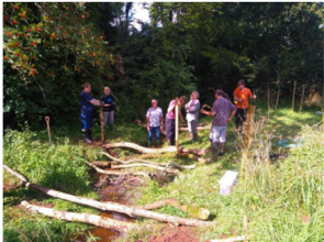
This is a community-led project in the catchments of the Roe and Ive Becks in Cumbria (Map 1) where the Roe Catchment Community Water Management Group, the Eden Rivers Trust, the Environment Agency, Durham University, Catchment Sensitive Farming, Cumbria County Council, the Forestry Commission and the Woodland Trust are working in partnership. A Masters by Research (MRes) project at Durham University commissioned by the project has identified the most important locations and techniques for reducing peak flow, and is now carrying out subsoiling, implementing targeted tree planting and creating leaky dams. The project is also one of the Cumbria Flood Partnership pilot catchments. There has been a positive approach to self-help with individual property resilience measures installed and a community flood warden scheme now in place.
The local community has been flooded 3 times. In 2005 and 2013 many houses were catastrophically flooded, with the property repairs taking over a year in several cases and some residents forced out of their homes. Working with Durham University this project has implemented various Natural Flood Management (NFM) measures to help reduce flood risk. To date this includes:
• soil aeration/subsoiling across 156 acres (63.1ha)
• installation of 25 leaky dams
Local residents have installed property level resilience measures, which alongside these NFM measures, helps to make their properties more resilient to flooding.
Monitoring surveys and results
Lessons learnt
Image gallery
|
Catchment and subcatchment
Site
Project background
Cost for project phases
Reasons for river restoration
Measures
MonitoringHydromorphological quality elements
Biological quality elements
Physico-chemical quality elements
Any other monitoring, e.g. social, economic
Monitoring documents
Additional documents and videos
Additional links and references
Supplementary InformationEdit Supplementary Information
| ||||||||||||||||||||||||||||||||||||||||||||||||||||||||||||||||||||||||||||||||||||||||||||||||||||||||||||||||||||||||||||||||||||||||||||||||||||||||||||||||||||||||||||||||||

