Case study:River Wandle Restoration Project: Difference between revisions
No edit summary |
No edit summary |
||
| Line 19: | Line 19: | ||
|Project summary=Delivered in three phases on the stretch of the Upper Wandle, referred to as the Carshalton arm, between two public parks, the Grove (upstream) and Wilderness Island (downstream). Phase one works comprised weir notching and the creation of woody debris habitat for fish and invertebrates. The second phase focused on further habitat enhancement and weir removal. Phase three works looking at opportunities along the wider Carshalton section and associated maintenance and monitoring of project works continues in 2012, led by the Wandle Trust. | |Project summary=Delivered in three phases on the stretch of the Upper Wandle, referred to as the Carshalton arm, between two public parks, the Grove (upstream) and Wilderness Island (downstream). Phase one works comprised weir notching and the creation of woody debris habitat for fish and invertebrates. The second phase focused on further habitat enhancement and weir removal. Phase three works looking at opportunities along the wider Carshalton section and associated maintenance and monitoring of project works continues in 2012, led by the Wandle Trust. | ||
}} | }} | ||
{{Image gallery}} | |||
{{Case study image | |||
|File name=TroutreddCarshalton.jpg | |||
|Caption=Trout spawning on the Carshalton arm, November 2012, © T. Longstaff (Wandle Trust) | |||
}} | |||
{{Image gallery end}} | |||
{{Toggle button}} | |||
{{Toggle content start}} | |||
{{Case study subcatchment | {{Case study subcatchment | ||
|Subcatchment=Wandle | |Subcatchment=Wandle | ||
| Line 69: | Line 77: | ||
{{Monitoring documents}} | {{Monitoring documents}} | ||
{{Monitoring documents end}} | {{Monitoring documents end}} | ||
{{Additional Documents}} | {{Additional Documents}} | ||
{{Additional Documents end}} | {{Additional Documents end}} | ||
| Line 80: | Line 82: | ||
{{Additional links and references footer}} | {{Additional links and references footer}} | ||
{{Supplementary Information}} | {{Supplementary Information}} | ||
{{Toggle content end}} | |||
Revision as of 08:34, 6 September 2013
Project overview
| Status | Complete |
|---|---|
| Project web site | |
| Themes | Fisheries, Habitat and biodiversity, Hydromorphology, Monitoring |
| Country | England |
| Main contact forename | Tim |
| Main contact surname | Longstaff |
| Main contact user ID | |
| Contact organisation | Wandle Trust |
| Contact organisation web site | http://www.wandletrust.org/ |
| Partner organisations | Environment Agency, Wild Trout Trust |
| Parent multi-site project | |
| This is a parent project encompassing the following projects |
No |
Project summary
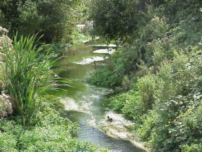
Delivered in three phases on the stretch of the Upper Wandle, referred to as the Carshalton arm, between two public parks, the Grove (upstream) and Wilderness Island (downstream). Phase one works comprised weir notching and the creation of woody debris habitat for fish and invertebrates. The second phase focused on further habitat enhancement and weir removal. Phase three works looking at opportunities along the wider Carshalton section and associated maintenance and monitoring of project works continues in 2012, led by the Wandle Trust.
Monitoring surveys and results
Lessons learnt
Image gallery
|
Catchment and subcatchmentSelect a catchment/subcatchment
Subcatchment:Wandle Other case studies in this subcatchment: River Wandle: Butter Hill Phase 3
Site
Project background
Cost for project phases
Reasons for river restoration
Measures
MonitoringHydromorphological quality elements
Biological quality elements
Physico-chemical quality elements
Any other monitoring, e.g. social, economic
Monitoring documents
Additional documents and videos
Additional links and references
Supplementary InformationEdit Supplementary Information
| ||||||||||||||||||||||||||||||||||||||||||||||||||||||||||||||||||||||||||||||||||||||||||||||||||||||||||||||||||||||||||||||||||||||||||||||||||||||||||||||||||||||||


