Case study:Stainby Road, Colsterworth: Difference between revisions
Dhutchinson (talk | contribs) No edit summary |
Dhutchinson (talk | contribs) No edit summary |
||
| (3 intermediate revisions by the same user not shown) | |||
| Line 15: | Line 15: | ||
|Contact organisation url=eastmercia.org/ | |Contact organisation url=eastmercia.org/ | ||
|Partner organisations=Environment Agency, | |Partner organisations=Environment Agency, | ||
|Name of parent multi-site project= | |Name of parent multi-site project=Case_study:Upper Witham Restoration | ||
|Multi-site=No | |Multi-site=No | ||
|Project picture=Colsterworth October 2023.JPG | |Project picture=Colsterworth October 2023.JPG | ||
| Line 23: | Line 23: | ||
A backwater was created along with floodplain ponds and the enhancement of spring tributaries from the valley sides allowed the creation of ground water fed scrapes. All material removed from the valley bottom was landscaped on the valley sides outside of the floodplain and planted with wildflower seed. | A backwater was created along with floodplain ponds and the enhancement of spring tributaries from the valley sides allowed the creation of ground water fed scrapes. All material removed from the valley bottom was landscaped on the valley sides outside of the floodplain and planted with wildflower seed. | ||
|Monitoring surveys and results=Project is very recent so just establishing. We have baseline data for fish and river habitat survey as well as detailed drone topo. Post monitoring work will commence from 24 on wards. | |Monitoring surveys and results=Project is very recent so just establishing. We have baseline data for fish and river habitat survey as well as detailed drone topo. Post monitoring work will commence from 24 on wards. | ||
River condition assessment pre and post delivery has taken place. | |||
|Lessons learn=Allow plenty of time for the development and delivery of a large project such as this where the ecological window for delivery is very limited. Involve all stakeholders at the earliest possible stage of development. Due to the sensitivity of the site, archaeology was a major factor and where this is the case adequate funding should be accounted for to the help manage this risk. Future management of the site is very important to ensure that high quality floodplain habitats are created. Here, the tenant farmer will continue with low density, conservation cattle grazing. The project was carefully designed to not back up any water onto the field immediately upstream. | |Lessons learn=Allow plenty of time for the development and delivery of a large project such as this where the ecological window for delivery is very limited. Involve all stakeholders at the earliest possible stage of development. Due to the sensitivity of the site, archaeology was a major factor and where this is the case adequate funding should be accounted for to the help manage this risk. Future management of the site is very important to ensure that high quality floodplain habitats are created. Here, the tenant farmer will continue with low density, conservation cattle grazing. The project was carefully designed to not back up any water onto the field immediately upstream. | ||
|Project title=Stainby Road, Colsterworth | |Project title=Stainby Road, Colsterworth | ||
| Line 50: | Line 52: | ||
{{Toggle button}} | {{Toggle button}} | ||
{{Toggle content start}} | {{Toggle content start}} | ||
{{Case study subcatchment}} | {{Case study subcatchment | ||
|Subcatchment=Upper Witham | |||
}} | |||
{{Site | {{Site | ||
|Name=Stainby Lane Colsterworth | |Name=Stainby Lane Colsterworth | ||
Latest revision as of 11:58, 27 February 2024
This case study is pending approval by a RiverWiki administrator.
Project overview
| Status | Complete |
|---|---|
| Project web site | |
| Themes | Habitat and biodiversity |
| Country | England |
| Main contact forename | Gail |
| Main contact surname | Talton |
| Main contact user ID | User:N/A |
| Contact organisation | Environment Agency |
| Contact organisation web site | http://eastmercia.org/ |
| Partner organisations | Environment Agency |
| Parent multi-site project | |
| This is a parent project encompassing the following projects |
No |
Project summary
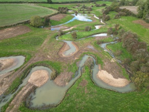
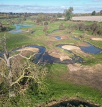
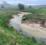
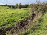
This project was delivered by East Mercia Rivers Trust on land owned by Buckminster Estates. Although the Upper Witham which flows through the site had retained a meandering course, the river had become very disconnected from its floodplain with very little gravel in the channel. The aim of the project was to improve the river’s connectivity with the floodplain and in the process, enhance both river and floodplain habitat across the site. This was achieved by the lowering of areas of floodplain across the site and the introduction of limestone gravel riffles and point bars. The selective addition of woody material at certain locations further improved habitat.
A backwater was created along with floodplain ponds and the enhancement of spring tributaries from the valley sides allowed the creation of ground water fed scrapes. All material removed from the valley bottom was landscaped on the valley sides outside of the floodplain and planted with wildflower seed.
Monitoring surveys and results
Project is very recent so just establishing. We have baseline data for fish and river habitat survey as well as detailed drone topo. Post monitoring work will commence from 24 on wards.
River condition assessment pre and post delivery has taken place.
Lessons learnt
Allow plenty of time for the development and delivery of a large project such as this where the ecological window for delivery is very limited. Involve all stakeholders at the earliest possible stage of development. Due to the sensitivity of the site, archaeology was a major factor and where this is the case adequate funding should be accounted for to the help manage this risk. Future management of the site is very important to ensure that high quality floodplain habitats are created. Here, the tenant farmer will continue with low density, conservation cattle grazing. The project was carefully designed to not back up any water onto the field immediately upstream.
Image gallery
|
Catchment and subcatchmentSelect a catchment/subcatchment
Catchment
Subcatchment
Other case studies in this subcatchment: Aubourn Rock Ramp and Habitat Works, Belton Floodplain Reconnection and River Restoration, Dysart Park, Grantham Habitat Improvement, Grantham Blue Green - Urban Reach, Little Ponton, Manthorpe Floodplain Reconnection, Papermill Weir Section in-channel restoration, River Witham Great Ponton, Syston and Barkston Restoration, Upper Cringle Floodplain Restoration Project... further results
Site
Project background
Cost for project phases
Reasons for river restoration
Measures
MonitoringHydromorphological quality elements
Biological quality elements
Physico-chemical quality elements
Any other monitoring, e.g. social, economic
Monitoring documents
Additional documents and videos
Additional links and references
Supplementary InformationEdit Supplementary Information
| ||||||||||||||||||||||||||||||||||||||||||||||||||||||||||||||||||||||||||||||||||||||||||||||||||||||||||||||||||||||||||||||||||||||||||||||||||||||||||||||||||||||||||||||||||||||||||||||||||||||||

