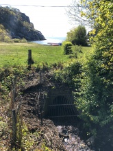
Case study:Deculverting Holtan stream: Difference between revisions
Jump to navigation
Jump to search
(Created page with "{{Case study status |Approval status=Draft }} {{Location |Location=59.052667240543244, 10.2251941317918 }} {{Project overview |Project title=Deculverting Holtan stream |Status...") |
No edit summary |
||
| (3 intermediate revisions by the same user not shown) | |||
| Line 6: | Line 6: | ||
}} | }} | ||
{{Project overview | {{Project overview | ||
|Status=Planned | |Status=Planned | ||
|Themes=Habitat and biodiversity, Urban | |Themes=Habitat and biodiversity, Urban | ||
| Line 13: | Line 12: | ||
|Main contact surname=Segarra Valls | |Main contact surname=Segarra Valls | ||
|Multi-site=No | |Multi-site=No | ||
|Project picture=Holtanbekken 13. mai 2020.jpg | |||
|Picture description=Culverted Holtan stream 13th May 2020. Picture: Miguel A. Segarra Valls | |||
|Project title=Deculverting Holtan stream | |||
}} | }} | ||
{{Image gallery}} | {{Image gallery}} | ||
| Line 19: | Line 21: | ||
{{Toggle content start}} | {{Toggle content start}} | ||
{{Case study subcatchment}} | {{Case study subcatchment}} | ||
{{Site}} | {{Site | ||
|Name=Holtanbekken | |||
|WFD water body code=NO015-439-R | |||
|WFD (national) typology=R108 | |||
|WFD water body name=Sandefjordsfjorden bekkefelt sør/vest | |||
|Heavily modified water body=No | |||
|Protected species present=Yes | |||
|Invasive species present=No | |||
|Species=Sea trout (Salmo trutta), European eel (Anguilla anguilla), | |||
}} | |||
{{Project background}} | {{Project background}} | ||
{{Motivations}} | {{Motivations}} | ||
| Line 34: | Line 45: | ||
{{Monitoring documents end}} | {{Monitoring documents end}} | ||
{{Additional Documents}} | {{Additional Documents}} | ||
{{Case study documents | |||
|File name=Not Holtanbekken Forslag til gjennaning J02.pdf | |||
|Description=Description of the culverted stream, and initial technical proposal for deculverting | |||
}} | |||
{{Case study documents | |||
|File name=El-fiske rapport SFFAL 18.10.2020.pdf | |||
}} | |||
{{Additional Documents end}} | {{Additional Documents end}} | ||
{{Additional links and references header}} | {{Additional links and references header}} | ||
Latest revision as of 16:02, 15 February 2021
This case study is pending approval by a RiverWiki administrator.
Location: 59° 3' 9.60" N, 10° 13' 30.70" E
Left click to look around in the map, and use the wheel of your mouse to zoom in and out.
Project overview
| Status | Planned |
|---|---|
| Project web site | |
| Themes | Habitat and biodiversity, Urban |
| Country | Norway |
| Main contact forename | Miguel A. |
| Main contact surname | Segarra Valls |
| Main contact user ID | |
| Contact organisation | |
| Contact organisation web site | |
| Partner organisations | |
| Parent multi-site project | |
| This is a parent project encompassing the following projects |
No |
Project summary
This case study hasn’t got any project summary, you can add some by editing the project overview.
Monitoring surveys and results
This case study hasn’t got any Monitoring survey and results, you can add some by editing the project overview.
Lessons learnt
This case study hasn’t got any lessons learnt, you can add some by editing the project overview.
Image gallery
|
Catchment and subcatchment
Site
Project background
Cost for project phases
Reasons for river restoration
Measures
MonitoringHydromorphological quality elements
Biological quality elements
Physico-chemical quality elements
Any other monitoring, e.g. social, economic
Monitoring documents
Additional documents and videos
Additional links and references
Supplementary InformationEdit Supplementary Information
| ||||||||||||||||||||||||||||||||||||||||||||||||||||||||||||||||||||||||||||||||||||||||||||||||||||||||||||||||||||||||||||||||||||||||||||||||||||||||||||||||||||||||||||||||||

