Case study:Wildling the Tame: Difference between revisions
No edit summary |
No edit summary |
||
| (One intermediate revision by the same user not shown) | |||
| Line 55: | Line 55: | ||
|Project started=2005 | |Project started=2005 | ||
}} | }} | ||
{{Motivations}} | {{Motivations | ||
{{Measures}} | |Hydromorphological quality elements=Channel pattern/planform, | ||
|Other motivation=Landscape enhancement, | |||
}} | |||
{{Measures | |||
|Bank and bed modifications measure=Channel reprofiling, Riffle creation, Habitat restoration, | |||
|Floodplain / River corridor=New footpaths, | |||
|Planform / Channel pattern=Channel widening, Reedbed creation, | |||
|Other technical measure=Improving water quality, | |||
|Social measures=Improved public access, | |||
}} | |||
{{Hydromorphological quality elements header}} | {{Hydromorphological quality elements header}} | ||
{{End table}} | {{End table}} | ||
Latest revision as of 09:31, 4 January 2019
Project overview
| Status | Complete |
|---|---|
| Project web site | |
| Themes | Fisheries, Habitat and biodiversity, Water quality |
| Country | England |
| Main contact forename | Tracey |
| Main contact surname | Doherty |
| Main contact user ID | User:TameValley |
| Contact organisation | Warwickshire Wildlife Trust |
| Contact organisation web site | http://www.tamevalleywetlands.co.uk/ |
| Partner organisations | |
| Parent multi-site project | |
| This is a parent project encompassing the following projects |
No |
Project summary
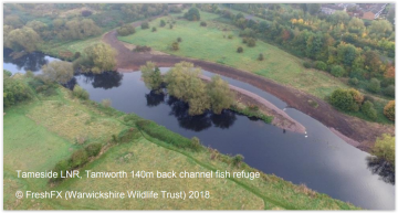
To restore 520 metre length of the River Tame – re-naturalising the river and improving
access for people.
Natural Environment Restoration - The project will restore natural river processes to the River Tame along the eastern edge of Kingsbury Water Park by altering the profile of the current incised river banks and widening the river. This will allow the natural development of riffles which will not only improve habitat but also increase aeration of the Tame and thus water quality. Spoil will be used in Hemlingford Water to shallow the eastern and northern edges, where a reedbed (a BAP priority habitat) will be created separately through Warwickshire County Council’s Higher Level Stewardship agreement (HLS), to increase biodiversity and prevent erosion at the edge of the lake from boat wash.
Improved Access - The re-profiling work will enable walkers using the footpath between Hemlingford Water and the River Tame to see the river which is at present hidden by a mound of dredgings. Access will be created on the left bank and improved on the right bank of the river. There will also be improved safety for locals who swim/paddle in the river.
A ramp will be created (from the spoil) to allow access from the raised walkway at the northern end of the site to the right bank of the river. This will create a circular walk along both banks of the Tame between the two bridges.
Monitoring surveys and results
- WFD Baseline data
- Fixed point photos before and after
- Aerial photos before and after
- river profile survey taken before
Bioblitz identified good fish stock eg lots of predatory fish. Lots of Bullhead, an LBAP species which is sensitive to water quality and European Eel a protected species.
Botanical survey showed natural regeneration of floodplain meadow indicator species eg Greater Burnett.
Lessons learnt
Image gallery
|
Catchment and subcatchment
Site
Project background
Cost for project phases
Reasons for river restoration
Measures
MonitoringHydromorphological quality elements
Biological quality elements
Physico-chemical quality elements
Any other monitoring, e.g. social, economic
Monitoring documents
Additional documents and videos
Additional links and references
Supplementary InformationEdit Supplementary Information
| ||||||||||||||||||||||||||||||||||||||||||||||||||||||||||||||||||||||||||||||||||||||||||||||||||||||||||||||||||||||||||||||||||||||||||||||||||||||||||||||||||||||||||||||||||

