Case study:Ennerdale Mill Weir Removal: Difference between revisions
(Created page with "{{Case study status |Approval status=Draft }} {{Location |Location=54.475291099389715, -3.5260548045046107 }} {{Project overview |Project title=Ennerdale Mill Weir Removal |St...") |
No edit summary |
||
| (15 intermediate revisions by 2 users not shown) | |||
| Line 1: | Line 1: | ||
{{Case study status | {{Case study status | ||
|Approval status= | |Approval status=Approved | ||
}} | }} | ||
{{Location | {{Location | ||
| Line 6: | Line 6: | ||
}} | }} | ||
{{Project overview | {{Project overview | ||
|Status=Complete | |Status=Complete | ||
|Project web site url=westcumbriariverstrust.org/projects/ennerdale-mill-weir-removal | |||
|Themes=Environmental flows and water resources, Fisheries, Habitat and biodiversity, Hydromorphology, Urban | |Themes=Environmental flows and water resources, Fisheries, Habitat and biodiversity, Hydromorphology, Urban | ||
|Country=England | |Country=England | ||
| Line 15: | Line 15: | ||
|Contact organisation=West Cumbria Rivers Trust | |Contact organisation=West Cumbria Rivers Trust | ||
|Contact organisation url=www.westcumbriariverstrust.org | |Contact organisation url=www.westcumbriariverstrust.org | ||
|Partner organisations=Natural England & Environment Agency | |||
|Multi-site=No | |Multi-site=No | ||
|Project picture=EMD Before.png | |||
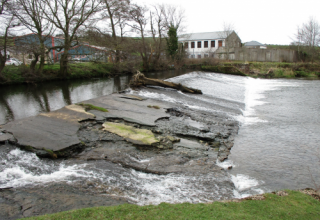
|Picture description=The weir at Ennerdale Mill, on the River Ehen in Egremont, prior to removal, showing significant damage to the structure and face of the weir | |||
|Project summary=Ennerdale Mill Weir, located on the River Ehen in Egremont (Grid Ref NY 012099) dates back over 250 years and was constructed to power the Ennerdale Paper Mill. The Weir has not been used as it was intended for many years and has been proven to be a barrier to migratory species of fish in the Ehen catchment, as well as a crucial site for Freshwater Mussels. | |||
A consortium of funders- WCRT, the Environment Agency, Natural England, the European Maritime and Fisheries Fund and James Fisher Nuclear- have combined resources to enable this weir removal project to take place over the summer of 2018. The project was delivered as part of the Cumbria River Restoration Strategy, a partnership between the EA, NE and WCRT. | |||
In June 2018, we mobilized to site to begin the delicate task of removing the weir, without causing ecological damage through the uncontrolled release of silt and sediment into the river system. A specialized contractor, Ebsford Environmental, were chosen to deliver the works, ensuring silt control measures were installed downstream of the weir. In addition, prior to the works, WCRT and Natural England conducted a translocation of freshwater mussels from within the work site, re-locating 48 mussels upstream of Egremont. | |||
The working methodology, developed by WCRT and AECOM, involved river bank re-profiling, berm lowering, re-grading of the existing riverbed & installation of toe protection (boulders that reinforce the river bank to provide protection against erosion), all conducted in a specific order to minimise sediment disturbance. Once the preparation was complete (approx. 4 weeks) we were ready to ‘notch’ the weir which lowered the water levels upstream, allowing the sediment & gravels that had built up over decades to be removed in the dry. Removing the weir structure itself took one week, and throughout that process Durham University were conducting heritage recording of the site so that we have a historic record of the structure of the weir. | |||
With the weir structure removed, the final tasks were to re-profile the riverbed and rapids upstream and downstream, and further strengthen the river banks with stone protection. | |||
Works completely finished on 31st July 2018, meaning the whole project was delivered in around 7 weeks. | |||
The Rivers Trust and the Environment Agency, supported by other partners, have been working with the Marine Management Organisation and Defra to develop a coordinated and funded programme of projects for 2018/19 with the aim of freeing migration routes of barriers to fish.This project is part of that programme funded by over £1.6 million of European Maritime and Fisheries Funds, which is matched by more than £1 million of Agency/Defra funding and £300,000 of other funds. | |||
|Monitoring surveys and results=Durham University undertook Archaeological Monitoring in 2017 and during the removal in 2018 | |||
Immediately post-removal WCRT have been conducting regular fixed-point photography across the site, to highlight how the river adapts and responds to being re-naturalised. | |||
Drone-captured aerial imagery has also been recorded post-removal; once collated this can be contrasted with the footage captured pre-removal for before-and-after analysis | |||
|Project title=Ennerdale Mill Weir Removal | |||
}} | }} | ||
{{Image gallery}} | {{Image gallery}} | ||
{{Case study image | |||
|File name=WSCT0702.JPG | |||
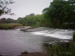
|Caption=View from below the weir, highlighting the extent of the drop in water levels | |||
}} | |||
{{Case study image | |||
|File name=Ennerdale Mill Weir - 2018-06-21 13.08.48 (Nathan D.).jpg | |||
|Caption=Installing sediment-trapping mats downstream of the weir, prior to removal | |||
}} | |||
{{Case study image | |||
|File name=20180706 113633.jpg | |||
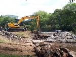
|Caption=Removing the actual structure, 6th July 2018 | |||
}} | |||
{{Case study image | |||
|File name=EMD After.png | |||
|Caption=Site of the former weir, 3 weeks after removal | |||
}} | |||
{{Case study image | |||
|File name=DSC04011.JPG | |||
|Caption=Gravel & cobble deposition is evident as the river is rapidly re-naturalising and responding to natural processes (December 2018) | |||
}} | |||
{{Case study image | |||
|File name=3 days after notching - weir structure exposed.jpg | |||
|Caption=3 days after notching - weir structure exposed | |||
}} | |||
{{Case study image | |||
|File name=EMD After 2.jpg | |||
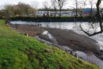
|Caption=After removal, showing the river bank vegetation recovering | |||
}} | |||
{{Image gallery end}} | {{Image gallery end}} | ||
{{Toggle button}} | {{Toggle button}} | ||
{{Toggle content start}} | {{Toggle content start}} | ||
{{Case study subcatchment}} | {{Case study subcatchment | ||
{{Site}} | |Subcatchment=River Ehen (lower) | ||
{{Project background}} | }} | ||
{{Motivations}} | {{Site | ||
{{Measures}} | |Name=River Ehen | ||
|Heavily modified water body=No | |||
|Protected species present=Yes | |||
|Invasive species present=No | |||
|Species=Freshwater pearl mussel (Margaritifera margaritifera), Atlantic salmon (Salmo salar), Brown trout (Salmo trutta), | |||
|Average bankfull channel width category=10 - 50 m | |||
|Average bankfull channel depth category=0.5 - 2 m | |||
}} | |||
{{Project background | |||
|Reach length directly affected=400 | |||
|Project started=01/04/2017 | |||
|Works started=2018/06/01 | |||
|Works completed=2018/07/31 | |||
|Project completed=2019/07/31 | |||
|Total cost category=100 - 500 k€ | |||
|Funding sources=Environment Agency, Marine Management Organisation, James Fisher Nuclear, Natural England, | |||
|Investigation and design cost category=10 - 50 k€ | |||
|Investigation and design Lead organisation=West Cumbria Rivers Trust | |||
|Stakeholder1 engagement cost category=10 - 50 k€ | |||
|Stakeholder engagement Lead organisation=West Cumbria Rivers Trust | |||
|Works1 and supervision cost category=100 - 500 k€ | |||
|Works and supervision Lead organisation=Ebsford Environmental | |||
|Post-project1 management and maintenance cost category=1 - 10 k€ | |||
|Post-project management and maintenance Lead organisation=West Cumbria Rivers Trust | |||
|Monitoring1 cost category=1 - 10 k€ | |||
|Monitoring Lead organisation=West Cumbria Rivers Trust | |||
}} | |||
{{Motivations | |||
|Specific mitigation=Barriers to fish migration, | |||
}} | |||
{{Measures | |||
|Bank and bed modifications measure=Weir removal | |||
}} | |||
{{Hydromorphological quality elements header}} | {{Hydromorphological quality elements header}} | ||
{{End table}} | {{End table}} | ||
| Line 35: | Line 117: | ||
{{End table}} | {{End table}} | ||
{{Monitoring documents}} | {{Monitoring documents}} | ||
{{Case study monitoring documents | |||
|Monitoring document=Durham Uni Archaeological Monitoring Report - July 2018.pdf | |||
}} | |||
{{Case study monitoring documents | |||
|Monitoring document=Ennerdale Mill Heritage Recording Initial Report.pdf | |||
}} | |||
{{Monitoring documents end}} | {{Monitoring documents end}} | ||
{{Additional Documents}} | {{Additional Documents}} | ||
Latest revision as of 14:58, 19 February 2019
Project overview
| Status | Complete |
|---|---|
| Project web site | http://westcumbriariverstrust.org/projects/ennerdale-mill-weir-removal |
| Themes | Environmental flows and water resources, Fisheries, Habitat and biodiversity, Hydromorphology, Urban |
| Country | England |
| Main contact forename | Luke |
| Main contact surname | Bryant |
| Main contact user ID | User:WCRT |
| Contact organisation | West Cumbria Rivers Trust |
| Contact organisation web site | http://www.westcumbriariverstrust.org |
| Partner organisations | Natural England & Environment Agency |
| Parent multi-site project | |
| This is a parent project encompassing the following projects |
No |
Project summary
Ennerdale Mill Weir, located on the River Ehen in Egremont (Grid Ref NY 012099) dates back over 250 years and was constructed to power the Ennerdale Paper Mill. The Weir has not been used as it was intended for many years and has been proven to be a barrier to migratory species of fish in the Ehen catchment, as well as a crucial site for Freshwater Mussels.
A consortium of funders- WCRT, the Environment Agency, Natural England, the European Maritime and Fisheries Fund and James Fisher Nuclear- have combined resources to enable this weir removal project to take place over the summer of 2018. The project was delivered as part of the Cumbria River Restoration Strategy, a partnership between the EA, NE and WCRT.
In June 2018, we mobilized to site to begin the delicate task of removing the weir, without causing ecological damage through the uncontrolled release of silt and sediment into the river system. A specialized contractor, Ebsford Environmental, were chosen to deliver the works, ensuring silt control measures were installed downstream of the weir. In addition, prior to the works, WCRT and Natural England conducted a translocation of freshwater mussels from within the work site, re-locating 48 mussels upstream of Egremont.
The working methodology, developed by WCRT and AECOM, involved river bank re-profiling, berm lowering, re-grading of the existing riverbed & installation of toe protection (boulders that reinforce the river bank to provide protection against erosion), all conducted in a specific order to minimise sediment disturbance. Once the preparation was complete (approx. 4 weeks) we were ready to ‘notch’ the weir which lowered the water levels upstream, allowing the sediment & gravels that had built up over decades to be removed in the dry. Removing the weir structure itself took one week, and throughout that process Durham University were conducting heritage recording of the site so that we have a historic record of the structure of the weir.
With the weir structure removed, the final tasks were to re-profile the riverbed and rapids upstream and downstream, and further strengthen the river banks with stone protection.
Works completely finished on 31st July 2018, meaning the whole project was delivered in around 7 weeks.
The Rivers Trust and the Environment Agency, supported by other partners, have been working with the Marine Management Organisation and Defra to develop a coordinated and funded programme of projects for 2018/19 with the aim of freeing migration routes of barriers to fish.This project is part of that programme funded by over £1.6 million of European Maritime and Fisheries Funds, which is matched by more than £1 million of Agency/Defra funding and £300,000 of other funds.
Monitoring surveys and results
Durham University undertook Archaeological Monitoring in 2017 and during the removal in 2018
Immediately post-removal WCRT have been conducting regular fixed-point photography across the site, to highlight how the river adapts and responds to being re-naturalised.
Drone-captured aerial imagery has also been recorded post-removal; once collated this can be contrasted with the footage captured pre-removal for before-and-after analysis
Lessons learnt
Image gallery
|
Catchment and subcatchmentSelect a catchment/subcatchment
Catchment
Subcatchment
Site
Project background
Cost for project phases
Reasons for river restoration
Measures
MonitoringHydromorphological quality elements
Biological quality elements
Physico-chemical quality elements
Any other monitoring, e.g. social, economic
Monitoring documents
Additional documents and videos
Additional links and references
Supplementary InformationEdit Supplementary Information
| ||||||||||||||||||||||||||||||||||||||||||||||||||||||||||||||||||||||||||||||||||||||||||||||||||||||||||||||||||||||||||||||||||||||||||||||||||||||||||||||||||||||||||||||||||||||||||||||||||||||||


