Case study:Rother meander reconnection: Difference between revisions
No edit summary |
No edit summary |
||
| (One intermediate revision by the same user not shown) | |||
| Line 117: | Line 117: | ||
}} | }} | ||
{{Measures | {{Measures | ||
|Bank and bed modifications measure=Re-grading, | |Bank and bed modifications measure=Re-grading,Planting, Riffle creation, | ||
|Floodplain / River corridor=Floodplain reconnection,Creation of | |Floodplain / River corridor=Floodplain reconnection, Creation of backwaters, Creation of pond, | ||
|Planform / Channel pattern=Re-instatement of old course, protect old lock from erosion. | |Planform / Channel pattern=Re-instatement of old course, protect old lock from erosion. | ||
}} | }} | ||
Latest revision as of 10:34, 5 June 2017
Project overview
| Status | Complete |
|---|---|
| Project web site | |
| Themes | Habitat and biodiversity, Hydromorphology, Land use management - agriculture, Monitoring |
| Country | England |
| Main contact forename | Damon |
| Main contact surname | Block |
| Main contact user ID | |
| Contact organisation | Environment Agency |
| Contact organisation web site | http://www.environment-agency.gov.uk |
| Partner organisations | River Restoration Centre |
| Parent multi-site project | |
| This is a parent project encompassing the following projects |
No |
Project summary
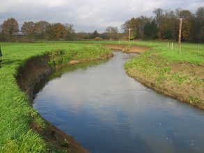
Shopham Loop is a section of the river Rother, West Sussex between Coultershaw Bridge and Shopham Bridge. A cut was created in the 18th century to bypass the meander and enable passage of boats upstream. However after navigation ceased, the locks were removed and the cut became the main river course with the meander (Shopham Loop) remaining as a backwater. Land use change to an intensive agricultural regime in turn led to shallower soils and increased siltation and the loop entrance became blocked with deposits preventing any flow from the Rother.
Monitoring surveys and results
Lessons learnt
Catchment and subcatchment
Edit the catchment and subcatchment details
(affects all case studies in this subcatchment)
Catchment
| River basin district | South East |
|---|---|
| River basin | Arun and Western Streams |
Subcatchment
| River name | Western Rother |
|---|---|
| Area category | 100 - 1000 km² |
| Area (km2) | |
| Maximum altitude category | 200 - 500 m |
| Maximum altitude (m) | 241241 m <br />0.241 km <br />24,100 cm <br /> |
| Dominant geology | Calcareous |
| Ecoregion | Great Britain |
| Dominant land cover | Arable and Horticulture |
| Waterbody ID | GB107041012810 |
Other case studies in this subcatchment: Western Rother Fishery Habitat Enhancement
Site
| Name | Shopham Loop |
|---|---|
| WFD water body codes | GB107041012810 |
| WFD (national) typology | Low, Medium, Calcareous |
| WFD water body name | Western Rother |
| Pre-project morphology | Single channel, High width:depth, Embanked |
| Reference morphology | Sinuous |
| Desired post project morphology | |
| Heavily modified water body | Yes |
| National/international site designation | |
| Local/regional site designations | |
| Protected species present | No |
| Invasive species present | No |
| Species of interest | |
| Dominant hydrology | Artificially regulated |
| Dominant substrate | Silt, Gravel |
| River corridor land use | Urban, Intensive agriculture |
| Average bankfull channel width category | 5 - 10 m |
| Average bankfull channel width (m) | |
| Average bankfull channel depth category | 2 - 5 m |
| Average bankfull channel depth (m) | |
| Mean discharge category | |
| Mean annual discharge (m3/s) | 4.974.97 m³/s <br />4,970 l/s <br /> |
| Average channel gradient category | |
| Average channel gradient | |
| Average unit stream power (W/m2) |
Project background
| Reach length directly affected (m) | 1000 m1 km <br />100,000 cm <br /> |
|---|---|
| Project started | 2000/03/01 |
| Works started | |
| Works completed | 2004/09/01 |
| Project completed | |
| Total cost category | |
| Total cost (k€) | 580 k€580,000 € <br /> |
| Benefit to cost ratio | |
| Funding sources |
Cost for project phases
| Phase | cost category | cost exact (k€) | Lead organisation | Contact forename | Contact surname |
|---|---|---|---|---|---|
| Investigation and design | |||||
| Stakeholder engagement and communication | |||||
| Works and works supervision | |||||
| Post-project management and maintenance | |||||
| Monitoring |
Reasons for river restoration
Measures
Structural measures
| |
|---|---|
| Bank/bed modifications | Re-grading, Planting, Riffle creation |
| Floodplain / River corridor | Floodplain reconnection, Creation of backwaters, Creation of pond |
| Planform / Channel pattern | Re-instatement of old course, protect old lock from erosion. |
| Other | |
Non-structural measures
| |
| Management interventions | |
| Social measures (incl. engagement) | |
| Other | |
Monitoring
Hydromorphological quality elements
| Element | When monitored | Type of monitoring | Control site used | Result | ||
|---|---|---|---|---|---|---|
| Before measures | After measures | Qualitative | Quantitative | |||
| Structure & condition of riparian zones | Yes | Yes | Improvement | |||
| Channel pattern/planform | Yes | Yes | Improvement | |||
Biological quality elements
| Element | When monitored | Type of monitoring | Control site used | Result | ||
|---|---|---|---|---|---|---|
| Before measures | After measures | Qualitative | Quantitative | |||
| Invertebrates | Yes | Yes | No | Yes | No | Inconclusive |
| Fish | No | Yes | No | Yes | Yes | Improvement |
| Macrophytes | No | Yes | No | Yes | No | Improvement |
Physico-chemical quality elements
| Element | When monitored | Type of monitoring | Control site used | Result | ||
|---|---|---|---|---|---|---|
| Before measures | After measures | Qualitative | Quantitative | |||
Any other monitoring, e.g. social, economic
| Element | When monitored | Type of monitoring | Control site used | Result | ||
|---|---|---|---|---|---|---|
| Before measures | After measures | Qualitative | Quantitative | |||
Monitoring documents
Image gallery
Additional documents and videos
Additional links and references
| Link | Description |
|---|---|
| http://publications.environment-agency.gov.uk/pdf/GESO0910BSTC-E-E.pdf | Environment Agency WFD Classification - See P.190. |
| http://www.therrc.co.uk/case studies/rother%20at%20shopham%20loop%20final.pdf | RRC Case Study - Shopham Loop |
| http://www.therrc.co.uk/MOT/Final Versions (Secure)/1.9 Shopham Loop.pdf | RRC Manual of Techniques best practice case study |
| http://www.therrc.co.uk/MOT/References/RRC Shopham Report FINAL.pdf | RRC report on the monitoring of the project - analysis & evaluation |
| http://www.therrc.co.uk/MOT/References/Darby 2003 Geomorph Basis Outline Design Shopham Loop.pdf | Geomorphological Basis of the Outline Design for the Shopham Loop Restoration |
| http://www.therrc.co.uk/PRAGMO/PRAGMO 2012-01-24.pdf#page=110 | Shopham case study in RRC's monitoring document 'PRAGMO' (2011) |


