Case study:The Red River: Abandoned Metal Mines: Difference between revisions
No edit summary |
No edit summary |
||
| (2 intermediate revisions by the same user not shown) | |||
| Line 1: | Line 1: | ||
{{Case study status | {{Case study status | ||
|Approval status= | |Approval status=Approved | ||
}} | }} | ||
{{Location | {{Location | ||
| Line 42: | Line 42: | ||
}} | }} | ||
{{Project background | {{Project background | ||
|Reach length directly affected=12km | |||
|Project started=2016/07/01 | |Project started=2016/07/01 | ||
}} | }} | ||
| Line 47: | Line 48: | ||
|Specific mitigation=Pollution incident, Mine drainage metal concentrations | |Specific mitigation=Pollution incident, Mine drainage metal concentrations | ||
}} | }} | ||
{{Measures}} | {{Measures | ||
|Wider stakeholder / citizen engagement=Improving water quality, | |||
}} | |||
{{Hydromorphological quality elements header}} | {{Hydromorphological quality elements header}} | ||
{{End table}} | {{End table}} | ||
Latest revision as of 10:27, 24 May 2017
Project overview
| Status | In progress |
|---|---|
| Project web site | |
| Themes | Environmental flows and water resources, Habitat and biodiversity, Monitoring, Water quality |
| Country | England |
| Main contact forename | Hugh |
| Main contact surname | Potter |
| Main contact user ID | |
| Contact organisation | Environment Agency |
| Contact organisation web site | |
| Partner organisations | The Coal Authority (UK) |
| Parent multi-site project | |
| This is a parent project encompassing the following projects |
No |
Project summary
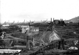
The Red River catchment is made up of three waterbodies - the Upper and Lower Red River and the Roseworthy Stream. The river drains a relatively small but intensively mined area of south-west Cornwall. Unlike many of the rivers impacted by metal mines in Cornwall, the Red River is affected not only by the legacy of historic mining throughout the catchment, but also, in the lower catchment, by more recent workings from South Crofty Tin Mine. Whereas most metal mines in Cornwall had ceased working by the early 1900's, 'Crofty' didn't close until 1998 and the site owner, Western United Mines' went into administration in June 2013. However, in July 2016 the Canadian firm Strongbow Exploration Inc acquired the rights to South Crofty, carrying out water treatment tests over winter as the mine will need de-watering.
Historic water quality data shows that Red River waters were severely affected by local mining activities between 1980 and 1998. In particular, waters arising from the South Crofty site during this period contained very high levels of particulate metal pollutants such as iron, zinc, copper and cadmium. The closure of South Crofty mine in 1998 resulted in a significant decrease in total metal concentrations downstream from the working site, although elevated levels of metals continue to arise from waters draining through historic mine workings such as the Treskillard Stream and Dolcoath deep adit discharge. In contrast to these improvements in river water quality, the closure and flooding of South Crofty mine (1998-2000) resulted in significant deterioration in the quality of Red River waters flowing downstream past Roscroggan portal (the Dolcoath adit discharge). Water quality data for the discharge, via Roscroggan portal, show that very high peaks in metal contaminant concentrations (along with additional flows) coincided with the decant of South Crofty mine waters in early November 2000.
More recent work has shown that the upper catchment is dominated by elevated copper from the Treskillard stream which drains abandoned mines from the south east of Camborne, and that under wet weather conditions there are additional inputs from tips and spoil heaps. In terms of impacts, in the Treskillard stream concentrations of Zn, Cu and Cd have been found to be 163ug/L, 363ug/L and 0.42ug/L respectively, with annual load of Zn of 230kg and Cu of 442kg. For the Dolcoath Adit the concentrations of Zn, Cu and Cd are 766ug/L, 23ug/L and 1.42ug/L respectively. The annual load of Zn is 3,400kg, and 106kg Cu.
Waterbody ecological status is Moderate
Length of watercourse affected is 12km
Water quality at WFD point (Gwithian) (ug/l): Zn = 196 (EQS = 75); Cu = 11.8 (EQS = 10); Cd = 0.28 (EQS = 0.15)
Likely bioavailable EQS at Gwithian (ug/l): Zn = 16; Cu = 7
Monitoring surveys and results
Lessons learnt
Image gallery
|
Catchment and subcatchmentSelect a catchment/subcatchment
Catchment
Subcatchment
Site
Project background
Cost for project phases
Reasons for river restoration
Measures
MonitoringHydromorphological quality elements
Biological quality elements
Physico-chemical quality elements
Any other monitoring, e.g. social, economic
Monitoring documents
Additional documents and videos
Additional links and references
Supplementary InformationEdit Supplementary Information
| ||||||||||||||||||||||||||||||||||||||||||||||||||||||||||||||||||||||||||||||||||||||||||||||||||||||||||||||||||||||||||||||||||||||||||||||||||||||||||||||||||||||||||||||||||||||||||||||||||||||||

