Case study:East Devon Diffuse Pollution Project: Difference between revisions
No edit summary |
No edit summary |
||
| (4 intermediate revisions by the same user not shown) | |||
| Line 1: | Line 1: | ||
{{Case study status | {{Case study status | ||
|Approval status= | |Approval status=Approved | ||
}} | }} | ||
{{Location | {{Location | ||
| Line 23: | Line 23: | ||
The project aims to identify and address potential sources of pollution on farmland, in order to protect water quality and wildlife habitats. The project is helping farmers reduce the amount of pesticides and fertiliser they use on their fields, constructing riverside fences, better drainage to prevent run-off into adjacent streams, soil management strategies, and habitat enhancement. | The project aims to identify and address potential sources of pollution on farmland, in order to protect water quality and wildlife habitats. The project is helping farmers reduce the amount of pesticides and fertiliser they use on their fields, constructing riverside fences, better drainage to prevent run-off into adjacent streams, soil management strategies, and habitat enhancement. | ||
Initial visits by contractors to the farms in the catchment focused on analysing soil maps and discussing the farmers' plan for field management following harvest season. | |||
|Lessons learn=Timing of the project - advice would have been more beneficial if delivered during 2015 earlier in the season. Also, the length of the project limits the scope of work which can be carried out. | |||
}} | }} | ||
{{Image gallery}} | {{Image gallery}} | ||
{{Case study image | |||
|File name=CPAF.png | |||
}} | |||
{{Image gallery end}} | {{Image gallery end}} | ||
{{Toggle button}} | {{Toggle button}} | ||
| Line 33: | Line 39: | ||
|Project started=2015/08/19 | |Project started=2015/08/19 | ||
|Project completed=2016/08/01 | |Project completed=2016/08/01 | ||
|Funding sources=Environment Agency Catchment Partnership Action Fund | |||
}} | }} | ||
{{Motivations | {{Motivations | ||
|Specific mitigation=Diffuse pollution | |||
|Physico-chemical quality elements=To improve water quality | |Physico-chemical quality elements=To improve water quality | ||
}} | }} | ||
Latest revision as of 16:14, 5 January 2017
Project overview
| Status | Complete |
|---|---|
| Project web site | |
| Themes | Land use management - agriculture, Water quality |
| Country | England |
| Main contact forename | Lisa |
| Main contact surname | Schneidau |
| Main contact user ID | User:Lisa Schneidau |
| Contact organisation | Devon Wildlife Trust |
| Contact organisation web site | http://www.devonwildlifetrust.org |
| Partner organisations | |
| Parent multi-site project | |
| This is a parent project encompassing the following projects |
No |
Project summary
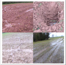
The East Devon Rural Diffuse Pollution Project was a one-year initiative aimed at reducing the diffuse pollution arising from rural land use, in particular the growing of maize, in the East Devon river catchments of Clyst, Axe and Otter.
The primary driver for the Catchment Based Approach is the need for the UK to meet its water quality obligations under the Water Framework Directive.
This is an approach to avoid detrimental damage to our drinking and bathing water supplies, by stopping pollutants entering watercourses. This project supports farmers who are based upstream of key water supplies, providing them with advice to manage their farms and businesses with clean water, and avoid negative environmental impacts.
The project aims to identify and address potential sources of pollution on farmland, in order to protect water quality and wildlife habitats. The project is helping farmers reduce the amount of pesticides and fertiliser they use on their fields, constructing riverside fences, better drainage to prevent run-off into adjacent streams, soil management strategies, and habitat enhancement.
Initial visits by contractors to the farms in the catchment focused on analysing soil maps and discussing the farmers' plan for field management following harvest season.
Monitoring surveys and results
Lessons learnt
Timing of the project - advice would have been more beneficial if delivered during 2015 earlier in the season. Also, the length of the project limits the scope of work which can be carried out.
Image gallery
|
Catchment and subcatchment
Site
Project background
Cost for project phases
Reasons for river restoration
Measures
MonitoringHydromorphological quality elements
Biological quality elements
Physico-chemical quality elements
Any other monitoring, e.g. social, economic
Monitoring documents
Additional documents and videos
Additional links and references
Supplementary InformationEdit Supplementary Information
| ||||||||||||||||||||||||||||||||||||||||||||||||||||||||||||||||||||||||||||||||||||||||||||||||||||||||||||||||||||||||||||||||||||||||||||||||||||||||||||||||||||||||||||||||||


