Case study:Houndsden Road Rain Gardens: Difference between revisions
No edit summary |
No edit summary |
||
| (11 intermediate revisions by 3 users not shown) | |||
| Line 1: | Line 1: | ||
{{Case study status | {{Case study status | ||
|Approval status= | |Approval status=Approved | ||
}} | }} | ||
{{Location | {{Location | ||
| Line 6: | Line 6: | ||
}} | }} | ||
{{Project overview | {{Project overview | ||
|Status= | |Status=In progress | ||
|Project web site url=http://www.thames21.org.uk/salmons-brook/ | |Project web site url=http://www.thames21.org.uk/salmons-brook/ | ||
|Themes=Flood risk management, Habitat and biodiversity, Social benefits, Water quality, Urban | |Themes=Flood risk management, Habitat and biodiversity, Social benefits, Water quality, Urban | ||
| Line 15: | Line 15: | ||
|Contact organisation=Thames 21 | |Contact organisation=Thames 21 | ||
|Contact organisation url=www.thames21.org.uk | |Contact organisation url=www.thames21.org.uk | ||
|Partner organisations=London Borough of Enfield, Thames Water, | |Partner organisations=London Borough of Enfield, Thames Water, | ||
|Name of parent multi-site project=Case_study:Rewilding Enfield's Urban Rivers | |Name of parent multi-site project=Case_study:Rewilding Enfield's Urban Rivers | ||
|Multi-site=No | |Multi-site=No | ||
| Line 31: | Line 31: | ||
In addition through this project we flagged up a highly polluting outfall, which was then investigated immediately and rectified, having an enormously positive effect on the health of the stream. | In addition through this project we flagged up a highly polluting outfall, which was then investigated immediately and rectified, having an enormously positive effect on the health of the stream. | ||
Interpretation will be created to showcase the benefit of rain gardens for rivers, as well as access improvements in the woodland to allow more people to get close to the stream. | |||
|Monitoring surveys and results=At the Houndsden Spinney it has thus far been impossible to collect road run off, so we have been unable to show an effect on water quality above and below the rain garden at this site. | |Monitoring surveys and results=At the Houndsden Spinney it has thus far been impossible to collect road run off, so we have been unable to show an effect on water quality above and below the rain garden at this site. | ||
Through our work alongside Thames Water and the EA to identify and rectify the misconnections blighting this site a significant improvement in water quality has been seen. We will soon be repeating invertebrate surveys to demonstrate this, along with public questionnaires which we hope will show an improvement in understanding of the urban water cycle and household misconnections. | Through our work alongside Thames Water and the EA to identify and rectify the misconnections blighting this site a significant improvement in water quality has been seen. We will soon be repeating invertebrate surveys to demonstrate this, along with public questionnaires which we hope will show an improvement in understanding of the urban water cycle and household misconnections. | ||
|Lessons learn=The road inlet designs had to be amended to capture water running along the gully with a road section cut out to allow a deep enough fall into swale. This has been rectified and the majority of run off is now entering the swales as designed. | |Lessons learn=The road inlet designs had to be amended to capture water running along the gully with a road section cut out to allow a deep enough fall into swale. This has been rectified and the majority of run off is now entering the swales as designed. | ||
The SuDS features are currently drier than anticipated. The resilient sedges are thriving, as are unwanted terrestrial plants. This has additional maintenance implications until replanting of edge species next spring. | The SuDS features are currently drier than anticipated. The resilient sedges are thriving, as are unwanted terrestrial plants. This has additional maintenance implications until replanting of edge species next spring. | ||
Originally a much larger wetland was planned at this site to clean water in the stream. However the project had to be significantly scaled back as we were unable to provide data needed to the EA to approve the scheme, as collecting this level data would have been prohibitively expensive. It would be better in future to allow for longer lead time on the project and budget far more for pre-project monitoring, however in this case it is still unlikely that we would have been able to fund the data required. Monitoring of schemes such as the Salmons Brook Healthy River Challenge is imperative to provide proof that SuDS are a positive element in the toolkit of approaches to tackle urban diffuse pollution. | Originally a much larger wetland was planned at this site to clean water in the stream. However the project had to be significantly scaled back as we were unable to provide data needed to the EA to approve the scheme, as collecting this level data would have been prohibitively expensive. It would be better in future to allow for longer lead time on the project and budget far more for pre-project monitoring, however in this case it is still unlikely that we would have been able to fund the data required. Monitoring of schemes such as the Salmons Brook Healthy River Challenge is imperative to provide proof that SuDS are a positive element in the toolkit of approaches to tackle urban diffuse pollution. | ||
}} | }} | ||
{{Image gallery}} | {{Image gallery}} | ||
| Line 68: | Line 64: | ||
|Subcatchment=Salmons Brook | |Subcatchment=Salmons Brook | ||
}} | }} | ||
{{Site}} | {{Site | ||
|Name=Houndsden Spinney | |||
|WFD water body code=GB106038027960 | |||
|WFD water body name=Salmons Brook | |||
|Heavily modified water body=Yes | |||
|Protected species present=No | |||
|Invasive species present=No | |||
}} | |||
{{Project background | {{Project background | ||
|Project started=2012/08/06 | |||
|Works started=2015/03/02 | |Works started=2015/03/02 | ||
|Works completed=2015/10/09 | |Works completed=2015/10/09 | ||
|Funding sources=London Borough of Enfield, corporate funder, Defra | |Funding sources=London Borough of Enfield, corporate funder, Defra | ||
}} | }} | ||
{{Motivations}} | {{Motivations | ||
{{Measures}} | |Specific mitigation=Urban diffuse pollution from road run off | ||
|Hydromorphological quality elements=n/a | |||
|Biological quality elements=Pollution limiting biological potential | |||
|Physico-chemical quality elements=Pollution from misconnections and road run off | |||
|Other motivation=Community demand, education project, interpretation of urban water cycle | |||
}} | |||
{{Measures | |||
|Floodplain / River corridor=Creation of swales and wetland basin | |||
|Management interventions=Opening of tree canopy to encourage varied ground flora, | |||
|Social measures=Community consultation, Community involvement, Interpretation boards, Improved public access, | |||
}} | |||
{{Hydromorphological quality elements header}} | {{Hydromorphological quality elements header}} | ||
{{End table}} | {{End table}} | ||
Latest revision as of 09:01, 3 January 2019
Project overview
| Status | In progress |
|---|---|
| Project web site | http://http://www.thames21.org.uk/salmons-brook/ |
| Themes | Flood risk management, Habitat and biodiversity, Social benefits, Water quality, Urban |
| Country | England |
| Main contact forename | Aimee |
| Main contact surname | Felus |
| Main contact user ID | User:AimeeThames21 |
| Contact organisation | Thames 21 |
| Contact organisation web site | http://www.thames21.org.uk |
| Partner organisations | London Borough of Enfield, Thames Water |
| Parent multi-site project | |
| This is a parent project encompassing the following projects |
No |
Project summary
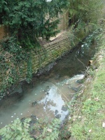
The Houndsden Gutter is a tributary of the Salmons Brook, a small river running through Enfield which joins the Lea Navigation. Like many urban streams it suffers from pollution. Oils and heavy metals wash off the roads when it rains, flowing into surface water drains which lead straight into our streams and rivers. The plumbing in some homes and businesses is misconnected, sending water from appliances, sinks and sometimes even toilets into watercourses instead of the sewers.
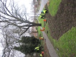
In 2015 we worked with the London Borough of Enfield to create two rain garden systems to improve the water quality in the stream. They have been designed to treat water that runs off Houndsden Road every time it rains, taking run-off from a busy section of Houndsden Road, which previously flowed directly into the Houndsden Gutter. Water is directed along the verge where it infiltrates into the soil or, in high flow conditions, into the large, natural woodland treatment basin.
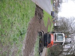
In the first system a two metre wide swale was created along the verge using a low impact digger. A footbridge was created to allow the swale to continue into the natural basin of the spinney. Kerbs were dropped at two points along the verge to allow water to enter the swales from the road. Finally, the road gully just up from the top of the system was filled so water would be redirected into the swales. Further down same road a second rain garden system was implemented in September 2015, made possible with match funding from LBE. These roadside rain gardens have allowed for another road gully to be filled and more road run-off off to be filtered before entering Houndsden Stream. This scheme consists of a swale and two rain gardens taking water from Houndsden Road. In low rainfall conditions water is temporarily stored in the rain garden basins and slowly infiltrates into the verge. In high rainfall conditions, and when the basins reach a critical limit, water is transferred through a pipe, under the footpath and into the natural woodland basin in the spinney.
The water treatment occurs in two ways. In the natural woodland basin of the Spinney, chemicals which would pollute the river are naturally and safely used by plants to grow or broken down by bacteria in the soil. The swales have been planted with sedges and native grasses to slow water flow and begin the treatment, and the woodland basin planted with suitable native seed mixes. Water will then naturally soak into the soil, recharging the water table. This is particularly important during times of summer drought. These rain gardens prevent oils and heavy metals washing into the Houndsden Gutter. The stream supports a small fish population, and fish are seriously impacted by such pollutants, so reducing the pollutant levels in the stream is of great importance.
In addition through this project we flagged up a highly polluting outfall, which was then investigated immediately and rectified, having an enormously positive effect on the health of the stream.
Interpretation will be created to showcase the benefit of rain gardens for rivers, as well as access improvements in the woodland to allow more people to get close to the stream.
Monitoring surveys and results
At the Houndsden Spinney it has thus far been impossible to collect road run off, so we have been unable to show an effect on water quality above and below the rain garden at this site.
Through our work alongside Thames Water and the EA to identify and rectify the misconnections blighting this site a significant improvement in water quality has been seen. We will soon be repeating invertebrate surveys to demonstrate this, along with public questionnaires which we hope will show an improvement in understanding of the urban water cycle and household misconnections.
Lessons learnt
The road inlet designs had to be amended to capture water running along the gully with a road section cut out to allow a deep enough fall into swale. This has been rectified and the majority of run off is now entering the swales as designed.
The SuDS features are currently drier than anticipated. The resilient sedges are thriving, as are unwanted terrestrial plants. This has additional maintenance implications until replanting of edge species next spring.
Originally a much larger wetland was planned at this site to clean water in the stream. However the project had to be significantly scaled back as we were unable to provide data needed to the EA to approve the scheme, as collecting this level data would have been prohibitively expensive. It would be better in future to allow for longer lead time on the project and budget far more for pre-project monitoring, however in this case it is still unlikely that we would have been able to fund the data required. Monitoring of schemes such as the Salmons Brook Healthy River Challenge is imperative to provide proof that SuDS are a positive element in the toolkit of approaches to tackle urban diffuse pollution.
Image gallery
|
Catchment and subcatchmentSelect a catchment/subcatchment
Catchment
Subcatchment
Other case studies in this subcatchment: Alma Road Rain Gardens, Bury Lodge Wetlands, Enfield Town Park Wetlands, Glenbrook Wetlands, Grovelands Park Wetlands, Laymer Road Silt Trap and Recreational Ground, Rewilding Enfield's Urban Rivers, Salmons Brook Flood Alleviation Scheme, Montagu Recreation Ground site, Salmons Brook River Restoration at Laymer Road, Salmons Brook at Grange Park
Site
Project background
Cost for project phases
Reasons for river restoration
Measures
MonitoringHydromorphological quality elements
Biological quality elements
Physico-chemical quality elements
Any other monitoring, e.g. social, economic
Monitoring documents
Additional documents and videos
Additional links and references
Supplementary InformationEdit Supplementary Information
| ||||||||||||||||||||||||||||||||||||||||||||||||||||||||||||||||||||||||||||||||||||||||||||||||||||||||||||||||||||||||||||||||||||||||||||||||||||||||||||||||||||||||||||||||||||||||||||||


