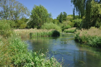
Case study:Charlton St Peter A 8: Difference between revisions
No edit summary |
No edit summary |
||
| (11 intermediate revisions by 2 users not shown) | |||
| Line 1: | Line 1: | ||
{{Case study status | {{Case study status | ||
|Approval status= | |Approval status=Approved | ||
}} | }} | ||
{{Location | {{Location | ||
| Line 15: | Line 15: | ||
|Name of parent multi-site project=Case_study:Strategic Framework for Restoration of the River Avon (SFfRRA) | |Name of parent multi-site project=Case_study:Strategic Framework for Restoration of the River Avon (SFfRRA) | ||
|Multi-site=No | |Multi-site=No | ||
|Project picture=Avon.jpg | |||
|Picture description=River Avon | |||
|Project summary=This reach is located at Charlton St Peter and is 1945m in length. The reach is designated SSSI but not SAC. There is good marginal habitat along both banks due to electric fencing being used to protect the banks from livestock. The upstream end of the channel is deeply incised with low floodplain connectivity as a result; the upstream end of the reach may have been dredged in the past. Ranunculus fluitantis is prevalent when the channel opens up and is not densely shaded. There is a private fishery nearby managed by the Rushall Estate. | |Project summary=This reach is located at Charlton St Peter and is 1945m in length. The reach is designated SSSI but not SAC. There is good marginal habitat along both banks due to electric fencing being used to protect the banks from livestock. The upstream end of the channel is deeply incised with low floodplain connectivity as a result; the upstream end of the reach may have been dredged in the past. Ranunculus fluitantis is prevalent when the channel opens up and is not densely shaded. There is a private fishery nearby managed by the Rushall Estate. | ||
There is evidence that the channel downstream of Charlton St Peter has been dredged. This has resulted in the formation of some high levees adjacent to the channel, which cut off the river from the floodplain and over-shades it in places. | There is evidence that the channel downstream of Charlton St Peter has been dredged. This has resulted in the formation of some high levees adjacent to the channel, which cut off the river from the floodplain and over-shades it in places. | ||
}} | }} | ||
{{Image gallery}} | {{Image gallery}} | ||
| Line 28: | Line 29: | ||
{{Site | {{Site | ||
|WFD water body code=GB108043022370 | |WFD water body code=GB108043022370 | ||
|WFD water body name=Hampshire Avon (West) | |||
|Heavily modified water body=No | |Heavily modified water body=No | ||
|Protected species present=No | |Protected species present=No | ||
|Invasive species present=No | |Invasive species present=No | ||
}} | }} | ||
{{Project background}} | {{Project background | ||
{{Motivations}} | |Reach length directly affected=1945 | ||
{{Measures}} | |Project started=2009/01/01 | ||
}} | |||
{{Motivations | |||
|Specific mitigation=Historic flood alleviation | |||
|Physico-chemical quality elements=Land drainage, Agricultural improvement | |||
|Other motivation=Urbanisation & development causing channelisation (deepening/widening/straightening/embanking), The use of sluice and weirs (creating barriers and flow impoundment) | |||
}} | |||
{{Measures | |||
|Bank and bed modifications measure=Bed raising, Weir modification, Weir removal, | |||
|Floodplain / River corridor=Remeandering, Modifying bank protection, Lowering of embankments, Riparian planting, | |||
|Planform / Channel pattern=Channel narrowing, Fencing, Introducing large woody debris, Enhancing flow diversity, altering flow splits, Re-instatement of old course, | |||
}} | |||
{{Hydromorphological quality elements header}} | {{Hydromorphological quality elements header}} | ||
{{End table}} | {{End table}} | ||
Latest revision as of 14:53, 2 January 2019
Project overview
| Status | Complete |
|---|---|
| Project web site | |
| Themes | Fisheries, Flood risk management, Habitat and biodiversity |
| Country | England |
| Main contact forename | Mike |
| Main contact surname | Porter |
| Main contact user ID | |
| Contact organisation | Environment Agency |
| Contact organisation web site | http://www.environment-agency.gov.uk |
| Partner organisations | |
| Parent multi-site project |
Case_study:Strategic Framework for Restoration of the River Avon (SFfRRA) |
| This is a parent project encompassing the following projects |
No |
Project summary
This reach is located at Charlton St Peter and is 1945m in length. The reach is designated SSSI but not SAC. There is good marginal habitat along both banks due to electric fencing being used to protect the banks from livestock. The upstream end of the channel is deeply incised with low floodplain connectivity as a result; the upstream end of the reach may have been dredged in the past. Ranunculus fluitantis is prevalent when the channel opens up and is not densely shaded. There is a private fishery nearby managed by the Rushall Estate.
There is evidence that the channel downstream of Charlton St Peter has been dredged. This has resulted in the formation of some high levees adjacent to the channel, which cut off the river from the floodplain and over-shades it in places.
Monitoring surveys and results
Lessons learnt
Image gallery
|
Catchment and subcatchmentSelect a catchment/subcatchment
Catchment
Subcatchment
Other case studies in this subcatchment: France Farm (Phase 1) A 9
Site
Project background
Cost for project phases
Reasons for river restoration
Measures
MonitoringHydromorphological quality elements
Biological quality elements
Physico-chemical quality elements
Any other monitoring, e.g. social, economic
Monitoring documents
Additional documents and videos
Additional links and references
Supplementary InformationEdit Supplementary Information
| ||||||||||||||||||||||||||||||||||||||||||||||||||||||||||||||||||||||||||||||||||||||||||||||||||||||||||||||||||||||||||||||||||||||||||||||||||||||||||||||||||||||||||||||||||||||||||||||

