Case study:Minsterley Brook Abandoned Metal Mines: Difference between revisions
No edit summary |
No edit summary |
||
| (20 intermediate revisions by 4 users not shown) | |||
| Line 1: | Line 1: | ||
{{Case study status | {{Case study status | ||
|Approval status=}} | |Approval status=Draft | ||
}} | |||
{{Location | {{Location | ||
|Location= | |Location=52.64121799999999, -2.9231170000000475 | ||
}} | }} | ||
{{Project overview | {{Project overview | ||
| Line 34: | Line 35: | ||
{{Image gallery}} | {{Image gallery}} | ||
{{Case study image | {{Case study image | ||
|File name= | |File name=Minsterley_key_sources_map.jpg | ||
}} | |||
{{Case study image | |||
|File name=120726_Snailbeach_headworks.JPG | |||
}} | |||
{{Case study image | |||
|File name=120726_White_Tip_Snailbeach.JPG | |||
}} | |||
{{Case study image | |||
|File name=120726_Restored_White_Tip.JPG | |||
}} | |||
{{Case study image | |||
|File name=Buddles_Snailbeach_Mine_Perimeter_Track_Copyright_Ian_Watson_Coal_Authority.jpg | |||
|Caption=Copyright Ian Watson Coal Authority | |||
}} | }} | ||
{{Image gallery end}} | {{Image gallery end}} | ||
| Line 40: | Line 54: | ||
{{Toggle content start}} | {{Toggle content start}} | ||
{{Case study subcatchment | {{Case study subcatchment | ||
|Subcatchment= | |Subcatchment=Minsterley Bk - source to conf Rea Bk | ||
}} | }} | ||
{{Site | {{Site | ||
|WFD water body code=GB109054049480 | |||
|WFD water body code= | |WFD water body name=Minsterley Bk - source to conf Rea Bk | ||
|WFD water body name= | |||
|Heavily modified water body=No | |Heavily modified water body=No | ||
|Protected species present=No | |||
|Invasive species present=No | |||
|Protected species present= | |River corridor land use=Improved/semi-improved grassland/pasture, | ||
|Invasive species present= | |||
|River corridor land use= | |||
}} | }} | ||
{{Project background}} | {{Project background}} | ||
{{Motivations | {{Motivations | ||
|Specific mitigation= | |Specific mitigation=abandoned mine pollution | ||
|Biological quality elements=Fish, Invertebrates, | |||
|Biological quality elements= | |Physico-chemical quality elements=Specific non-synthetic pollutants, | ||
|Physico-chemical quality elements= | |||
}} | }} | ||
{{Measures | {{Measures | ||
|Floodplain / River corridor=Water treatment methods, | |||
|Floodplain / River corridor= | |Management interventions=Walkover surveys and water sample data collection, | ||
|Wider stakeholder / citizen engagement=Ecological survey, | |||
|Management interventions= | |||
|Wider stakeholder / citizen engagement= | |||
}} | }} | ||
{{Hydromorphological quality elements header}} | {{Hydromorphological quality elements header}} | ||
{{ | {{End table}} | ||
|Element= | {{Biological quality elements header}} | ||
|Monitored before= | {{Biological quality element table row | ||
|Monitored after= | |Element=Fish | ||
|Qualitative monitoring= | |Monitored before=No | ||
|Quantitative monitoring= | |Monitored after=No | ||
|Control site used= | |Qualitative monitoring=No | ||
|Quantitative monitoring=No | |||
|Control site used=No | |||
}} | }} | ||
{{ | {{Biological quality element table row | ||
|Element= | |Element=Invertebrates | ||
|Monitored before= | |Monitored before=No | ||
|Monitored after= | |Monitored after=No | ||
|Qualitative monitoring= | |Qualitative monitoring=No | ||
|Quantitative monitoring= | |Quantitative monitoring=No | ||
|Control site used= | |Control site used=No | ||
}} | }} | ||
{{End table}} | {{End table}} | ||
{{Physico-chemical quality elements header}} | {{Physico-chemical quality elements header}} | ||
| Line 113: | Line 105: | ||
{{Additional links and references header}} | {{Additional links and references header}} | ||
{{Additional links and references | {{Additional links and references | ||
|Link= | |Link=restorerivers.eu/wiki/index.php?title=File%3AMinsterley_key_sources_map.jpg | ||
}} | }} | ||
{{Additional links and references footer}} | {{Additional links and references footer}} | ||
{{Supplementary Information}} | {{Supplementary Information}} | ||
{{Toggle content end}} | {{Toggle content end}} | ||
Latest revision as of 16:48, 13 November 2018
This case study is pending approval by a RiverWiki administrator.
Project overview
| Status | In progress |
|---|---|
| Project web site | |
| Themes | Environmental flows and water resources, Habitat and biodiversity, Monitoring, Water quality |
| Country | England |
| Main contact forename | Andrew |
| Main contact surname | Pearson |
| Main contact user ID | |
| Contact organisation | Environment Agency |
| Contact organisation web site | |
| Partner organisations | The Coal Authority (UK) |
| Parent multi-site project | |
| This is a parent project encompassing the following projects |
No |
Project summary
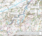
Minsterley Brook catchment includes a number of separate mines as part of the South Shropshire Metal Mining area, including Snailbeach, Tankerville, and Roman Gravels mines. The catchment is part of the Rea Brook which drains into the main River Severn at Shrewsbury. The mines were worked for mainly lead ores, but also zinc ore and latterly barites until closure in the 1940s, leaving spoil deposits and drainage adits which discharge to Minsterley Brook at various points. The mines are a significant source of heavy metal pollution in the catchment, and the discharges from them represent one of the longest continuous sources of pollution in the whole Severn River Basin.
http://restorerivers.eu/wiki/index.php?title=File%3AMinsterley_key_sources_map.jpg
Environment Agency routine monitoring found there were high levels of zinc in Minsterley Brook over most of its length, exceeding the Environmental Quality Standards (EQS) for the brook (75ug/l). As a result, the watercourse isn't achieving the 'Good status' for water quality as set out in our Severn River Basin Plan. The Boat Level adit discharge is the main source of the zinc (around 3000kg per annum) and other heavy metals, such as cadmium and lead, and discharges these pollutants into the Hogstow Brook. Immediately downstream of the Boat Level adit the zinc concentrations are up to 47x the EQS. At Minsterley, the zinc concentrations are 8x the EQS. Downstream of the mines, concentrations exceed the EQS for over 15km, until the Rea Brook reaches Hanwood and dilution from other rivers lowers the concentration to below the EQS.
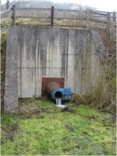
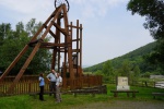
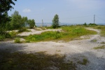
Ecological surveys of the brooks have found aquatic insects were suffering as a result of these heavy metals, which can settle in river sediments. There is also a lower than expected population of small fish species. There are four other, smaller discharges of metals into the catchment from Snailbeach Spoil Tip, Wood Adit, Roman Gravels and Tankerville spoil tips, which together contribute about a quarter of the metal load in wet conditions. These spoil heaps are listed on the Mining Waste Directive Inventory of sites causing serious environmental harm. Snailbeach Spoil Tip (also known as White Tip) is part of the Snailbeach mine schedule monument, and “ranks as one of the best surviving examples of a lead mining complex". http://restorerivers.eu/wiki/index.php?title=File%3A120726_Snailbeach_headworks.JPG http://restorerivers.eu/wiki/index.php?title=File%3A120726_White_Tip_Snailbeach.JPG http://restorerivers.eu/wiki/index.php?title=File%3A120726_Restored_White_Tip.JPG http://restorerivers.eu/wiki/index.php?title=File%3ABuddles_Snailbeach_Mine_Perimeter_Track_Copyright_Ian_Watson_Coal_Authority.jpg
The Environment Agency continue to investigate and monitor the water quality in the Minsterley and Rea Brooks, and with funding from Defra have set up a partnership with the Coal Authority to look at options for potentially removing the metals from discharges. The ultimate aim is to construct long term sustainable treatment schemes that deal with the problem at the source and help the Minsterley & Rea Brooks to meet the EQS and return to 'Good' ecological and chemical status.
Investigations to date have identified that the discharges from the Boat Level and Snailbeach Spoil Tip are the most feasible to be treated (subject to pilot trials), and the Coal Authority are carrying out comprehensive flow monitoring of these discharges. Using waters from Snailbeach Spoil tip, the partnership is working with academics and consultants to develop possible treatment technologies, such as ion exchange, to remove the metals from the discharges. Once treatment options have been identified, the partnership will consult with the public and other stakeholders on the next stages.
Monitoring surveys and results
Lessons learnt
Image gallery
|
Catchment and subcatchmentSelect a catchment/subcatchment
Catchment
Subcatchment
Site
Project background
Cost for project phases
Reasons for river restoration
Measures
MonitoringHydromorphological quality elements
Biological quality elements
Physico-chemical quality elements
Any other monitoring, e.g. social, economic
Monitoring documents
Additional documents and videos
Additional links and references
Supplementary InformationEdit Supplementary Information
| ||||||||||||||||||||||||||||||||||||||||||||||||||||||||||||||||||||||||||||||||||||||||||||||||||||||||||||||||||||||||||||||||||||||||||||||||||||||||||||||||||||||||||||||||||||||||||||||||||||||||||||||||||||||||


